- California State Route 138
-
"Pearblossom Highway" redirects here. For information about the 1986 David Hockney photomontage, see David Hockney.
State Route 138
Route information Defined by S&HC § 438 Maintained by Caltrans Length: 105.376 mi[1] (169.586 km)
SR 138 is broken into pieces, and the length does not reflect the SR 14 overlap that would be required to make the route continuous.Major junctions West end:  I-5 near Gorman
 SR 14 in Palmdale
 I-15 near Cajon Pass
East end:  SR 18 near Crestline
Highway system State highways in California(list • pre-1964)
History • Unconstructed • Deleted • Freeway • Scenic←  SR 137
SR 139  →
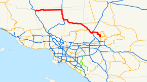
→State Route 138 is an east–west state highway generally following the northern foothills of the San Gabriel Mountains of southern California, USA from its junction with Interstate 5 south of Gorman eastward to Mount Anderson Junction, its eastern junction with State Route 18 south of Crestline in the San Bernardino Mountains. Except for the western two miles (3 km) of the route between Interstate 5 and just east of Gorman Post Road and a segment shared with State Route 14 between Avenue D in Lancaster and Palmdale Boulevard in Palmdale, it is all surface road, mostly undivided two-lane road. The remaining section of the Ridge Route, California's first highway connecting the San Joaquin Valley to the Los Angeles Basin, ends at 138 in Gorman.
This route is part of the California Freeway and Expressway System[2] and is eligible for the State Scenic Highway System.[3]
Contents
Route description
The western leg of State Route 138 traverses the Lancaster Freeway from Interstate 5 to Gorman Post Road, Lancaster Road from Gorman Post Road to 245th Street West near Neenach School, and Avenue D from 245th Street West to Route 138s north junction with State Route 14. The Lancaster Freeway has four lanes, two for each direction of travel. Both Lancaster Road and Avenue D are 2-lane conventional roads; Avenue D is on a straight alignment over its 22 miles (35 km) between 245th Street and State Route 14.
After its co-routing with the Antelope Valley Freeway (SR 14) through Lancaster and Palmdale, it passes through Palmdales eastside as four-laned Palmdale Boulevard, 47th Street East, and Fort Tejon Road to Avenue T. At Avenue T it tapers to two lanes and continues straight ahead on Pearblossom Highway through Littlerock, Pearblossom, and Llano to its west junction with State Route 18. Route 18s western terminus siphons off Las Vegas-bound travelers from 138. At its west junction with State Route 18, State Route 138 turns southeast on Antelope Highway to the Los Angeles/San Bernardino County line where it loses its alternative name, Antelope Highway.
Between the county line and Interstate 15, State Route 138 traverses very mountainous and scenic terrain and it connects with State Route 2 that leads to winter resort areas in the San Gabriel Mountains used largely by residents of greater Los Angeles and greater San Diego. State Route 138 then descends through the West Cajon Valley and crosses Interstate 15 in the Cajon Pass. From Interstate 15 to State Route 173, near the northwest corner of Silverwood Lake, traffic on State Route 138 is rather sparse. The remaining road past Silverwood Lake is mountainous, narrow, and twisting, and not a prime mountain route to the San Bernardino Mountain resorts. The entire segment from Interstate 15 to the eastern terminus of State Route 138 at Mount Anderson Junction is known the El Cajon-Skyline Forest Highway.
Because of its twisting, mountainous segments and overloaded traffic conditions on its eastern leg, State Route 138 east of Palmdale and west of Interstate 15 is the site of numerous serious auto accidents as of 2004, according to CHP data. One of the chief contributors to accidents on Route 138 of late is drivers passing on the two-lane highway in unsafe conditions. A recent[when?] accident involved a vehicle leaving the roadway near the California Aqueduct, careering through the desert and crashing into the aqueduct.[citation needed]
Parts of the distinctive highway were used in the filming of the movie The Long, Long Trailer, a 1954 comedy with Lucille Ball and Desi Arnaz. Despite the rapid growth of Southern California in the ensuing fifty years, the segment shown in the movie is little changed since the movie was filmed.
David Hockney composed the picturesque photographic collage Pearblossom Highway in 1986 off of the segment of Route 138 bearing that moniker. It may be viewed at the Getty Museum in Los Angeles.
Future
A proposed bypass to the north of downtown Palmdale has been studied by Caltrans. The bypass would be located east of the Antelope Valley Freeway and south of LA/Palmdale Regional Airport along Avenue P-8, reconnecting with the current SR 138 east of Palmdale.
Major intersections
- Note: Except where prefixed with a letter, postmiles were measured in 1964, based on the alignment as it existed at that time, and do not necessarily reflect current mileage. The numbers reset at county lines; the start and end postmiles in each county are given in the county column.
County Location Postmile
[4][5][6]Exit
[7]Destinations Notes Los Angeles
LA R0.00-74.97R0.00 I-5 (Golden State Freeway) – Los Angeles, SacramentoWestbound exit and eastbound entrance R0.24 Quail Lake Road Westbound exit and eastbound entrance East end of freeway 1.71 Gorman Post Road – Gorman 4.11  CR N2 (Old Ridge Route Road)
Three Points Road – Three Points, Lake Hughes 170th Street West – Antelope Valley California Poppy Reserve 90th Street West – Antelope Acres 36.87
R74.00[N 1] SR 14 north (Antelope Valley Freeway) / Avenue D (to Sierra Highway) – MojaveInterchange; west end of SR 14 overlap West end of freeway on SR 14 R72.00[N 1] 47 Avenue F Lancaster R70.99[N 1] 46 Avenue G R69.99[N 1] 45 Avenue H R68.97[N 1] 44 Avenue I R67.96[N 1] 43 Avenue J (CR N5) Eastbound exit and westbound entrance R67.39[N 1] 43 20th Street West Westbound exit and eastbound entrance R66.73[N 1] 42 Avenue K R65.68[N 1] 41 Avenue L R64.68[N 1] 40 Avenue M Also known as Columbia Way Palmdale R63.67[N 1] 39 Avenue N R61.77[N 1] 37 10th Street West Eastbound exit and westbound entrance; serves LA/Palmdale Regional Airport R61.37[N 1] 37 Rancho Vista Boulevard (Avenue P) Westbound exit and eastbound entrance; serves LA/Palmdale Regional Airport East end of freeway on SR 14 R59.80[N 1]
43.42 SR 14 south (Antelope Valley Freeway) / CR N2 (Palmdale Boulevard) – Los AngelesInterchange; east end of SR 14 overlap 44.42 Sierra Highway Former US 6 / SR 14 48.59 50th Street East, Palmdale Boulevard Avenue S 51.41 Pearblossom Highway, Avenue T – Los Angeles 106th Street East – Juniper Hills Pearblossom 60.17  CR N6 (Longview Road) – Valyermo, Devil's Punchbowl, Big Rock Camp
63.68 165th Street East – Lake Los Angeles, Crystalaire, Valyermo Llano  CR N4 (Largo Vista Road)
69.30 SR 18 east (Palmdale Road) – VictorvilleSan Bernardino
SBD 0.00-R37.85Pinon Hills 2.91 Phelan Road, Green Road – Phelan, Hesperia 5.76 Sheep Creek Road – Phelan Interchange; westbound exit only 6.66  SR 2 west (Angeles Crest Highway) – Wrightwood, Big Pines
R15.20 I-15 (Mojave Freeway) – Victorville, San BernardinoInterchange Hesperia R23.96  SR 173 – Hesperia
R28.48 Cleghorn Road – Silverwood Lake Interchange R37.85 SR 18 – Lake Arrowhead, San BernardinoInterchange 1.000 mi = 1.609 km; 1.000 km = 0.621 mi
Concurrency terminus • Closed/Former • Incomplete access • UnopenedReferences
- ^ January 1, 2006 California Log of Bridges on State Highways
- ^ CA Codes (shc:250-257)
- ^ CA Codes (shc:260-284)
- ^ California Department of Transportation, State Truck Route List (XLS file), accessed February 2008
- ^ California Department of Transportation, Log of Bridges on State Highways, July 2007
- ^ California Department of Transportation, All Traffic Volumes on CSHS, 2005 and 2006
- ^ California Department of Transportation, California Numbered Exit Uniform System, State Route 14 Freeway Interchanges, Retrieved on 2009-01-26.
External links
Categories:- Palmdale, California
- State highways in California
- Roads in Los Angeles County, California
- Roads in San Bernardino County, California


Wikimedia Foundation. 2010.