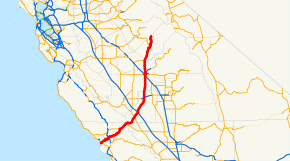
- California State Route 41
-
"CA 41" redirects here. For the congressional district, see California's 41st congressional district.
State Route 41
Route information Defined by S&HC § 341 Maintained by Caltrans Length: 185.594 mi[1] (298.685 km)
(plus about 6.5 mi (10.5 km) on SR 46)Existed: 1933 – present Major junctions South end:  SR 1 in Morro Bay
 US 101 in Atascadero
 SR 198 in Lemoore
 SR 99 in Fresno
 SR 49 in Oakhurst
North end:  SR 140 in Yosemite National Park
Highway system State highways in California(list • pre-1964)
History • Unconstructed • Deleted • Freeway • Scenic←  I-40
I-40SR 42  →
→State Route 41 (SR 41) is a state highway in the U.S. state of California, connecting the Cabrillo Highway (SR 1) in Morro Bay with Fresno and Yosemite National Park via the San Joaquin Valley. Except between US 101 in Atascadero and SR 46 near Shandon, SR 41 is part of the California Freeway and Expressway System. It has been constructed as an expressway from near SR 198 in Lemoore north to the south part of Fresno, where the Yosemite Freeway begins, passing along the east side of downtown and extending north into Madera County.
Contents
Route description
Three segments — from SR 1 to US 101, SR 46 to SR 33, and SR 49 at Oakhurst to Yosemite (the Wawona Road) - are eligible for inclusion in the State Scenic Highway System, but none of the route has been officially designated as such.[2]
SR 41 is known as the E.G. Lewis Highway from SR 1 to US 101 in San Luis Obispo County, the Dwight David Eisenhower Memorial Freeway from Ventura Avenue in Fresno to Herndon Avenue in Fresno, the Donald DeMers Highway from Jensen Avenue in Fresno to Elkhorn Avenue, the Yosemite Freeway from Elkhorn Avenue to the Fresno-Madera County line, the Southern Yosemite Highway from the Fresno-Madera County line to Yosemite National Park, and the Wawona Road from Fresno to Yosemite National Park.[3]
The majority of Route 41 runs as either two-lane rural highway or four-lane divided highway. The southern end of the freeway intersects SR 1 in Morro Bay. Between Morro Bay and Fresno, the highway intersects U.S. Route 101 in Atascadero, proceeds through the Coastal Range and intersects SR 46. Actor James Dean died in an accident at the intersection of SR 46 in Cholame. Currently, there is a memorial located there. The interchange is now called the James Dean Memorial Interchange. SR 41 then intersects Interstate 5 to the south of Kettleman City, and SR 198 just outside of the city of Lemoore. A large hazardous waste and municipal solid waste disposal facility operated by Waste Management, Inc. is located 5.6 km (3.5 mi) SSW of Kettleman City on the west side of the highway. The El Adobe de los Robles Rancho built by pioneer Daniel Rhoads can be found north of Lemoore.
In Fresno, the route intersects SR 99 near Jensen Avenue. Compete access is not available between SR 41/SR 99. For example, there is no direct connector between the southbound SR 41 and northbound SR 99; drivers wanting to make this transition must exit at the SR 41/SR 180 interchange, head west on SR 180, and then transition onto SR 99 at the interchange between those two freeways. Likewise, there is no direct connector between the northbound SR 41 and the southbound SR 99. Drivers must exit at Jensen Avenue, head east on Jensen Avenue until its junction with SR 99 a half-mile east of SR 41, and then make the southbound transition onto SR 99.
SR 41 continues north into the city, then intersects SR 180 at a section of the latter route that links SR 41 to both SR 99 to the west, and to SR 168 to the east. North of Fresno, the route crosses the San Joaquin River, and enters Madera County near Children's Hospital of Central California. 8.5 miles (13.7 km) further north, Route 41 intersects with SR 145, before entering California's Sierra-Nevada mountain range. Route 41 continues through the towns of Coarsegold and Oakhurst, where it intersects with SR 49. Route 41 ends in Yosemite National Park to the north.
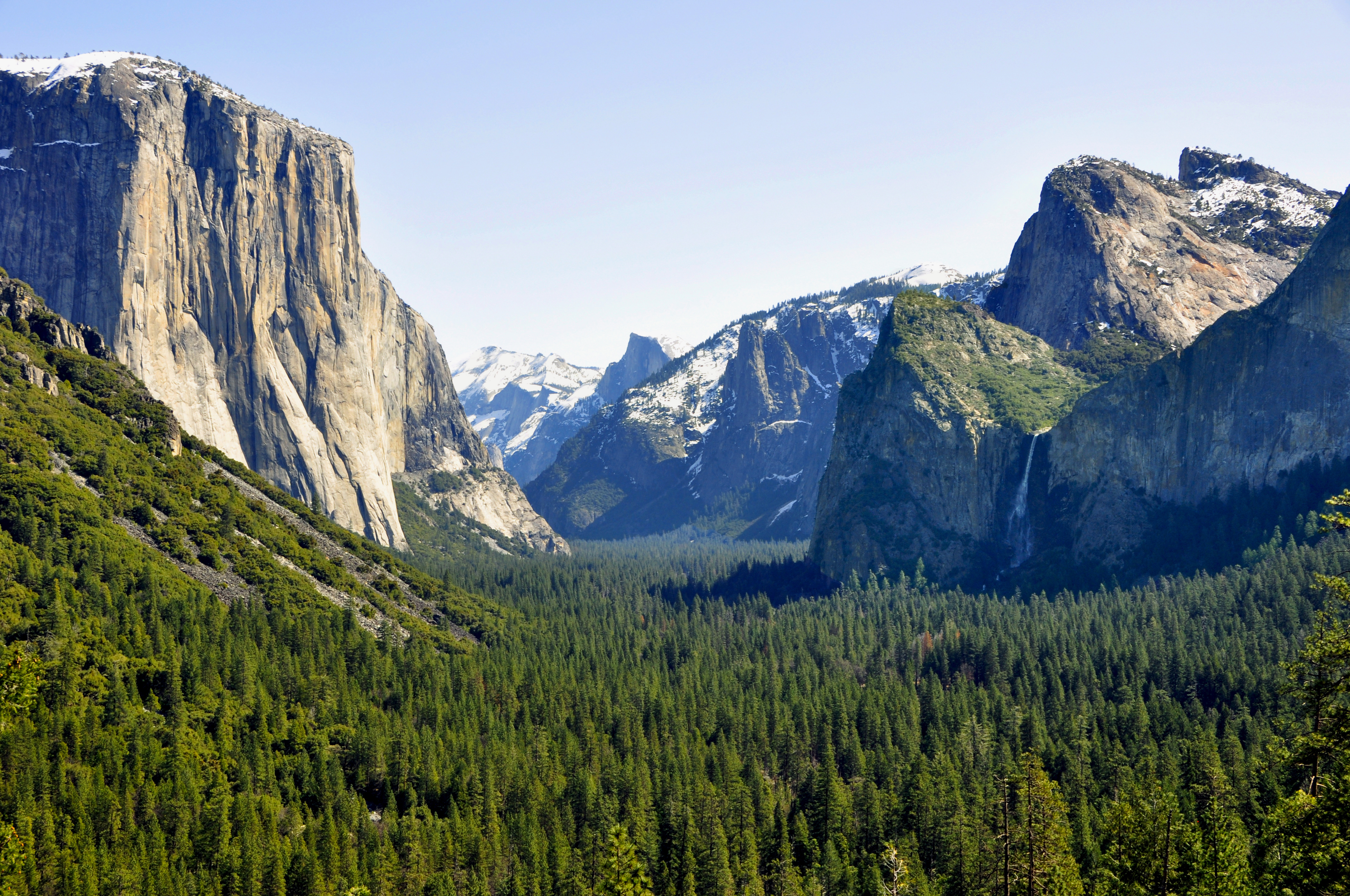
 East portal of Wawona Tunnel near eastern terminus of SR 41
Tunnel View is a viewpoint located just outside the east end of the Wawona Tunnel in Yosemite National Park. It is located about 1.5 miles (2.4 km) from the Yosemite Valley. This is the first view that most people have of Yosemite Valley. There is an END-41 sign just south of the southern entrance to Yosemite National Park. The state routes within the park are not signed (with the exception of SR 120). Tunnel View is along Route 41's alignment, although state maintenance of the route ends at the south entrance of the park.
History
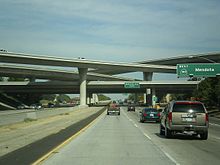 Northbound on Route 41 in Fresno at the Route 180 interchange
In 1930, the counties of Fresno, Kings, Kern, and San Luis Obispo considered organizing a joint highway district to construct a shortcut connecting Fresno with the Pacific Ocean at Morro Bay. This highway would pass through Kettleman City on its way to the Cholame Lateral (Legislative Route 33) near Cholame or Shandon, and then continue to Morro Bay, where a new harbor was being developed.[4][5] The entire length from Fresno to Morro Bay, as well as the Wawona Road to Yosemite, was added to the state highway system in 1933 as Route 125,[6][7] and subsequently improved by the state. In 1934, the state sign route system was established, and Sign Route 41 was designated along Route 125 from Yosemite south and southwest to Cholame and then west through Paso Robles to Cambria via Legislative Route 33.[8] The part of Route 125 southwest of Cholame instead became part of the new U.S. Route 466.[9]
By the 1950s, the short piece of US 466 (Route 125) between Creston and Atascadero had not yet been paved, and so US 466 was moved to the longer but better road via Paso Robles, replacing SR 41 to Paso Robles and overlapping US 101 to Atascadero. As SR 41 had not been signed over the unpaved road west of Paso Robles, it was truncated to Cholame.[10] US 466 was eliminated in the 1964 renumbering, becoming SR 46 east from Paso Robles. However, instead of going south and west to Morro Bay, SR 46 continued west to Cambria, and the road via Creston and Atascadero to Morro Bay (which had since been paved) became part of SR 41.[11][12]
In the 1980s, the urban stretch of 41 running through Fresno was upgraded to freeway standards, intersecting SR 99 to the south. In the late 1990s and early 2000s, the freeway portion was extended several miles beyond Fresno in both directions.
Major intersections
Note: Except where prefixed with a letter, postmiles were measured on the road as it was in 1964, and do not necessarily reflect current mileage. The numbers reset at county lines; the start and end postmiles in each county are given in the county column.
County Location Postmile
[1][13][14]Exit
[15]Destinations Notes San Luis Obispo
SLO 0.00-50.43Morro Bay 0.00 Atascadero Road Continuation beyond SR 1 0.00 SR 1 – Cayucos, Cambria, Hearst CastleInterchange Atascadero 15.89 US 101 – San FranciscoInterchange 15.96 El Camino Real 27.98  SR 229 south – Creston
Creston Road, La Panza Road – Paso Robles Shandon Road – Paso Robles Shandon 43.81  SR 46 west – Paso Robles
South end of SR 46 overlap Cholame SR 46 east – BakersfieldNorth end of SR 46 overlap; former US 466 east Kern
KER 0.00-4.98No major junctions Kings
KIN 0.00-R48.288.10  SR 33 – Avenal, Taft
16.28  I-5 – Sacramento, Los Angeles
Interchange Laurel Avenue – Stratford Kansas Avenue – Corcoran, Tulare R37.79 Jackson Avenue – Lemoore NAS Lemoore R39.96 SR 198 – Hanford, Sequoia Park, Coalinga, Lemoore NASInterchange South end of freeway R40.95 Bush Street North end of freeway R42.15 Hanford-Armona Road R48.28 Excelsior Avenue Interchange Fresno
FRE R0.00-33.45R2.03 Mount Whitney Avenue – Laton, Riverdale R8.11 Conejo Avenue R10.11 Mountain View Avenue – Caruthers, Selma R14.10 Manning Avenue – Raisin City 
 SR 41 Bus. north (Adams Avenue) – Easton
SR 41 Bus. south (American Avenue) – EastonR19.11 Central Avenue South end of freeway Fresno R20.11 124 North Avenue R21.13 125 Jensen Avenue R21.90 126A SR 99 north – Madera, SacramentoNorthbound exit and southbound entrance R21.90 126A SR 99 south – Bakersfield, Los AngelesSouthbound exit and northbound entrance R22.80 126B Van Ness Avenue – Civic Center Former SR 180 R22.95 127A O Street Southbound exit only R23.74 127B Tulare Street, Divisadero Street Signed as exit 127 northbound R24.53 128  SR 180 (Sequoia-Kings Canyon Freeway) – Mendota, Kings Canyon
Signed as exits 128A (east) and 128B (west) northbound R25.26 129 McKinley Avenue R26.46 130 Shields Avenue R27.47 131 Ashlan Avenue R28.47 132 Shaw Avenue – Clovis Former SR 168; serves California State University Fresno R29.46 133 Bullard Avenue R30.45 134 Herndon Avenue – Clovis R31.68 135 Friant Road, Blackstone Avenue – Millerton Lake Madera
MAD 0.00-45.74R1.20 138 Rio Mesa Boulevard, Children's Boulevard (SR 41 Bus. north) Signed as exits 138A (Rio Mesa Boulevard) and 138B (Children's Boulevard) northbound North end of freeway 3.23
SR 41 Bus. south (Avenue 12) – Madera Ranchos9.25  SR 145 south to SR 99 north / Road 145 – Madera, Millerton Lake
Oakhurst 35.48 SR 49 north – Ahwahnee, MariposaMariposa
MPA 0.00-4.92Fish Camp 4.92 North end of state maintenance at Yosemite National Park south boundary SR 140 eastNorthbound access to SR 140 east only 1.000 mi = 1.609 km; 1.000 km = 0.621 mi
Concurrency terminus • Closed/Former • Incomplete access • UnopenedReferences
- ^ a b California Department of Transportation, State Truck Route List (XLS file), accessed February 2008
- ^ California Department of Transportation, California Scenic Highway Mapping System, accessed January 2008
- ^ 2007 Named Freeways, Highways, Structures and Other Appurtenances in California. Caltrans. p. 128. http://www.dot.ca.gov/hq/tsip/hseb/products/Named_Freeways.pdf. Retrieved 2007-03-28.
- ^ Los Angeles Times, Morro Bay Road Looms, April 26, 1930, p. 4
- ^ Fresno Bee, Fresno-To-Coast Highway Proposal Looks Favorable, May 7, 1930
- ^ "An act...relating to...the addition of certain highways to the State system.", 1933 chapter 767, p. 2037, 2038: "State Highway Route 4 near Fresno to Yosemite National Park." "State Highway Route 56 near Moro [sic] to State Highway Route 4 near Fresno via Stratford."
- ^ "An act to establish a Streets and Highways Code...", 1935 chapter 29, p. 283, 284: "Route 125 is from: (a) Route 56 near Morro to Route 4 near Fresno via Stratford. (b) Route 4 near Fresno to Yosemite National Park."
- ^ California Highways and Public Works, State Routes will be Numbered and Marked with Distinctive Bear Signs, August 1934
- ^ Richard F. Weingroff, U.S. 666: "Beast of a Highway"?
- ^ H.M. Gousha Company, California, 1955
- ^ H.M. Gousha Company, California, 1963
- ^ "An act...relating to routes on the state highway system.", 1963 chapter 385, p. 1175
- ^ California Department of Transportation, Log of Bridges on State Highways, July 2007
- ^ California Department of Transportation, All Traffic Volumes on CSHS, 2005 and 2006
- ^ California Department of Transportation, California Numbered Exit Uniform System, State Route 41 Freeway Interchanges, Retrieved on 2009-02-05.
External links
- California @ WestCoastRoads.com - State Route 41
- Caltrans: Route 41 highway conditions
- California Highways: Route 41
Categories:- State highways in California
- Freeways in California
- Roads in San Luis Obispo County, California
- Roads in Kern County, California
- Roads in Kings County, California
- Roads in Fresno County, California
- Roads in Madera County, California
- Roads in Mariposa County, California


Wikimedia Foundation. 2010.