- Claremorris
-
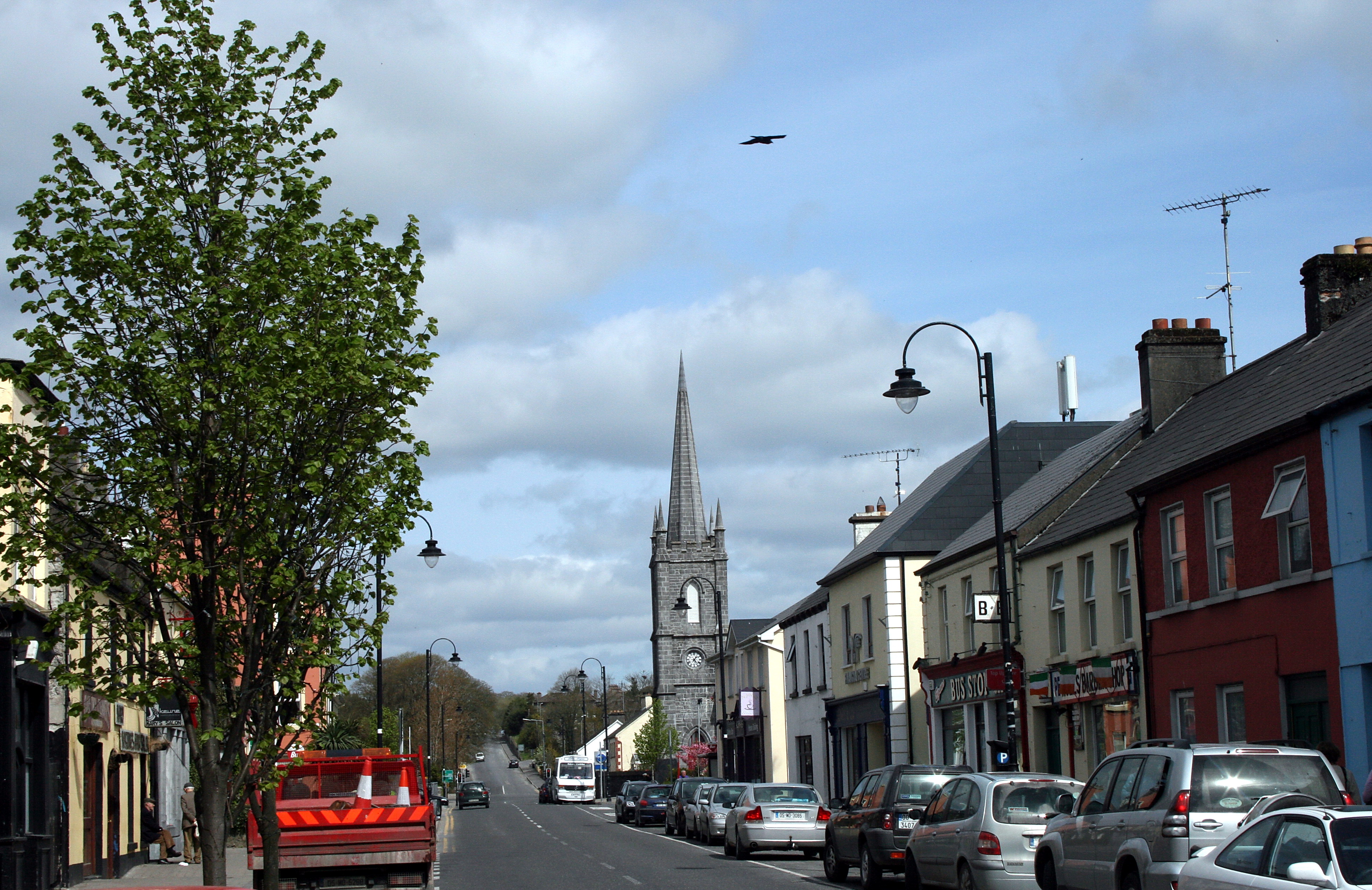
Claremorris
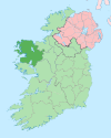
Clár Chlainne Mhuiris— Town — Claremorris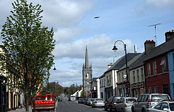 Location in Ireland
 Claremorris
Coordinates: 53°43′12″N 8°59′56″W / 53.720°N 8.999°WCoordinates: 53°43′12″N 8°59′56″W / 53.720°N 8.999°W Country Ireland Province Connacht County County Mayo Elevation 73 m (240 ft) Population (2011)[1] – Urban 3,979 Irish Grid Reference M338751 Historical populations Year Pop. ±% 1821 1,297 — 1831 1,476 +13.8% 1841 2,256 +52.8% 1851 1,560 −30.9% 1861 1,323 −15.2% 1871 1,103 −16.6% 1881 1,319 +19.6% 1891 1,259 −4.5% 1901 1,118 −11.2% 1911 1,069 −4.4% 1926 1,107 +3.6% 1936 1,132 +2.3% 1946 1,045 −7.7% 1951 1,063 +1.7% 1956 1,512 +42.2% 1961 1,519 +0.5% 1966 1,479 −2.6% 1971 1,718 +16.2% 1981 2,036 +18.5% 1986 1,992 −2.2% 1991 1,907 −4.3% 1996 1,914 +0.4% 2002 2,101 +9.8% 2006 2,595 +23.5% [2][3][4][5][6] Claremorris (Irish: Clár Chlainne Mhuiris), is a town in County Mayo in the west of Ireland, at the junction of the N17 and the N60 national routes. It has a population of approximately 3,979 in 2011.
Claremorris sits at the bottom of a valley with all roads which lead to the town following hills in particular the old Knock road (known as the Knock hill) and Ballyhaunis road. Although low lying the town does not experience flooding. There is no major river through the town.
Claremorris is the fastest growing town in County Mayo. There was a 25% increase in the town's population between 2006 and 2011 and a 23% increase between 2002 and 2006.
Contents
Name
The town derived its name from Maurice de Prendergast, a Norman who came to Ireland in 1169. The town was established during the 18th century.
Amenities
Many new shops have been added in the last few years, including The Silverbridge Shopping Centre. With the development of Chapel Lane from a derelict street to a commercial street, this part of the town has been transformed. Four supermarkets compete for customers in the town including retail giants Tesco and Aldi.
There are three hotels including the modern 4-star McWilliam Park Hotel, which opened in late 2006. It has a leisure centre, swimming pool and conference facilities. The town has several restaurants catering for Italian, Indian, Chinese and Irish cuisine.
Claremorris has many pubs, however a number have closed down in recent years. The town has two nightclubs.
A swimming pool and leisure centre opened on September 1, 2009. A new Garda Station opened in 2008. A new 6-screen cinema has been planned.
There are two secondary schools - St Colman's College for boys and Mount St. Michael for girls - and several primary schools.
The surrounding countryside is of rolling drumlins, eskers, woods and lakes.
Genealogical records for Claremorris consist of Roman Catholic church records of marriage which commenced in 1805 and baptisms which commenced in 1825. Church of Ireland records consist of baptisms from 1834 onwards, marriages from 1846 onwards and burials from 1878 onwards. These are held at the South Mayo Family Research Centre in Ballinrobe.
Sports
There are a number of sporting clubs including:
- The Gaelic Athletic Association, who train at many pitches in the town, and compete at many levels from under-10s up to senior in both Men's & Ladies' Competitions. They have been County Mayo senior hurling champions twice: 1968, and 1971 and senior county Gaelic football champions four times: 1961, 1964, 1965 and 1971.
- The Swimming Club train at the all-new, ultra-modern Claremorris Leisure Centre. The swimming club incorporates water polo. In recent years the team became the first club from Connacht to win the all-Ireland under 16 & under 19 Boys championships, as well as being the first club to win the inaugural Girls Under-16 & Under-19 Championships.
- The new Claremorris Leisure Centre opened on September 1, 2009. It has a 25 metre, 6 lane, short course competition pool. It also incorporates a large gymnasium & fitness studio. It offers a wide variety of fitness classes.[7]
- The Soccer Club, which trains & plays their matches at Concannon park. Derek Glynn began his career playing for Claremorris.
- The Golf club play at the local 18-hole course located just outside Claremorris on the Galway Road
- The Athletics Club train on the racetrack.
- The Tennis Club courts at the centre of town are the most modern in Mayo.
Transport
Road
Claremorris is situated at a major road junction. The N17 (Galway-Sligo road) and the N60 (Castlebar-Roscommon road) meet in the town. Claremorris was once a major traffic bottleneck.
The busy N17 trundled through the town and met the N60 at a staggered junction at market square in the town, this junction as well as the old Bank of Ireland corner (where Galway Road meets Ballinrobe Road), were the worst blackspots in the town. By the late 1990s, over 13,000 vehicles were trundling through the town daily.
In 1994 a design for the bypass was completed by Mayo County Council, the CPO went ahead in 1995. Then there was a 3 year wait for funding for the scheme. Eventually in 1998 the go ahead was given and construction of the bypass commenced. The N17 bypass opened in July 2001. Journey times at peak periods were reduced by 30 minutes on the Galway/Sligo route after the opening. The project was built as a grade separated single carriageway which is rare for single carriageway bypasses in Ireland. The new 16km road bypassed one of Irelands most treacherous national routes, the original 7 mile stretch between Claremorris and Knock had a very high accident rate due to its poor alignment. The busy N60 still passes through the town via an inner relief road. A second bypass for the town is included in the proposed new N60 road to Castlebar, although this road won't be built until at least 2018.
Rail
Claremorris is served by the Westport/Ballina-Dublin railway. There is currently a campaign underway to open the western rail corridor through Claremorris linking Limerick to Sligo. The Claremorris-Tuam phase is due to open in 2014.
Weather Station
Claremorris is home to one of Ireland's eight inland weather observing stations, located 2 kilometres from the town centre. It began recording weather in November 1943 and was run and staffed by a local family. During WWII Ireland provided detailed weather reports to the Allies. Weather reports from Claremorris and Blacksod Lighthouse (located on the west coast of Mayo) played a significant factor in selecting the date of launch for the invasion of France (D Day) on the 6th June 1944. Many will remember the weather expert in the film "The Longest Day", imparting this information to Gen. Eisenhower and the Joint Chiefs of Staff. In 1949 it was decided that the Irish Meteorological Service needed observations on an hourly basis from inland stations like Claremorris. It was decided to staff the station with full time permanent personnel. In 1996 staff were relocated to Knock airport and it now operates automatically with data uploaded to Dublin [1].[8]
Climate
Claremorris has a temperate oceanic climate with cold winters and warm damp summers. The coldest months being January and February and the wettest being December and October. Claremorris received roughly 1,500 hours of sunshine in 2010.
Climate data for Claremorris, 1961-1990 Month Jan Feb Mar Apr May Jun Jul Aug Sep Oct Nov Dec Year Record high °C (°F) 13.1
(55.6)13.3
(55.9)20.1
(68.2)22.3
(72.1)25.1
(77.2)29.8
(85.6)31.5
(88.7)27.2
(81.0)23.3
(73.9)19.9
(67.8)15.4
(59.7)14.3
(57.7)31.5
(88.7)Average high °C (°F) 7.2
(45.0)7.6
(45.7)9.6
(49.3)12.0
(53.6)14.5
(58.1)17.0
(62.6)18.4
(65.1)18.2
(64.8)16.1
(61.0)13.2
(55.8)9.5
(49.1)7.9
(46.2)12.6 Daily mean °C (°F) 4.3
(39.7)4.5
(40.1)5.9
(42.6)7.6
(45.7)10.0
(50.0)12.6
(54.7)14.3
(57.7)14.0
(57.2)12.1
(53.8)9.8
(49.6)6.2
(43.2)5.1
(41.2)8.9 Average low °C (°F) 1.4
(34.5)1.3
(34.3)2.3
(36.1)3.3
(37.9)5.5
(41.9)8.2
(46.8)10.2
(50.4)9.8
(49.6)8.1
(46.6)6.3
(43.3)3.0
(37.4)2.3
(36.1)5.1 Record low °C (°F) −11.7
(10.9)−17.1
(1.2)−8
(18)−5.5
(22.1)−3.1
(26.4)−0.4
(31.3)0.6
(33.1)1.1
(34.0)−1.2
(29.8)−4
(25)−5.3
(22.5)−8.3
(17.1)−17.1
(1.2)Precipitation mm (inches) 121.1
(4.768)82.9
(3.264)95.8
(3.772)61.7
(2.429)77.5
(3.051)71.7
(2.823)63.4
(2.496)96.9
(3.815)104.2
(4.102)125.9
(4.957)111.8
(4.402)123.5
(4.862)1,136.4
(44.74)% humidity 91 91 88 84 80 81 84 87 89 92 92 92 88 Avg. precipitation days (≥ 0.2 mm) 22 17 21 17 18 16 17 19 19 22 21 22 230 Avg. snowy days 6.5 5.4 4.7 1.9 0.3 0.0 0.0 0.0 0.0 0.1 1.7 3.5 24.1 Source: [2] People
The town is the birthplace of:
- Cardinal John D'Alton.
- Provost of Trinity College John Hegarty
- Sir John Gray
- Seamus O'Malley, who captained Mayo to their first All Ireland Senior Football Championship in 1936
- Lucinda Creighton TD
- Pat Rabbitte TD, former Labour Party leader
- Derek Glynn Irish Soccer Player (striker)
Local Schools
- St. Colman's College, boys' secondary school.
- Mount St. Michael, girls' secondary school.
Local Events
- The Claremorris Open Exhibition, is an annual arts exhibition in the town held since 1978.
See also
External links
- Claremorris Chamber of Commerce
- Claremorris
- Claremorris, The Heart of the West
- Claremorris Golf Club
- West=on=Track
- Claremorris Community Radio
References
- ^ "Census 2006 – Volume 1 – Population Classified by Area" (PDF). Central Statistics Office Census 2006 Reports. Central Statistics Office Ireland. April 2007. http://www.cso.ie/census/documents/census2006_volume_1_pop_classified_by_area.pdf. Retrieved 2011-06-14.
- ^ Census for post 1821 figures.
- ^ http://www.histpop.org
- ^ http://www.nisranew.nisra.gov.uk/census
- ^ Lee, JJ (1981). "On the accuracy of the Pre-famine Irish censuses". In Goldstrom, J. M.; Clarkson, L. A.. Irish Population, Economy, and Society: Essays in Honour of the Late K. H. Connell. Oxford, England: Clarendon Press.
- ^ Mokyr, Joel; O Grada, Cormac (November). "New Developments in Irish Population History, 1700-1850". The Economic History Review 37 (4): 473–488. doi:10.1111/j.1468-0289.1984.tb00344.x. http://www3.interscience.wiley.com/journal/120035880/abstract
- ^ Claremorris Leisure Centre
- ^ "Met Éireann". Claremorris History. http://www.met.ie/about/weatherobservingstations/claremorris_history.asp.
- The Gray Family of Claremorris, Co. Mayo, Thomas Ormsby Ruttledge, in The Irish Genealogist 7, 1989
Places in County Mayo Towns - Ballina
- Ballinrobe
- Ballyhaunis
- Belmullet
- Castlebar
- Claremorris
- Foxford
- Kiltimagh
- Swinford
- Westport
Villages
and townlands- Attymass
- Aughagower
- Aughleam
- Balla
- Ballindine
- Ballintubber
- Ballycastle
- Ballyglass
- Bangor Erris
- Bekan
- Belcarra
- Belderrig
- Bellacorick
- Bellavary
- Binghamstown
- Bohola
- Bonniconlon
- Breaffy
- Carracastle
- Carrowteige
- Castlehill
- Charlestown
- Charlestown-Bellahy
- Cill Ghallagáin
- Cogaula
- Cong
- Corrimbla
- Corroy
- Cregganbaun
- Cross
- Crossmolina
- Delphi
- Derrew
- Doohoma
- Dooniver
- Drummin
- Errew
- Glenamoy
- Glencastle
- Glengad
- Glenhest
- Gob an Choire
- Gweesalia
- Hollymount
- Islandeady
- Keel
- Kilcummin
- Kilkelly
- Killala
- Kilmaine
- Kilmeena
- Kilmovee
- Knock
- Lahardane
- Lecanvey
- Louisburgh
- Mayo
- Meelick
- Moygownagh
- Mulranny
- Murrisk
- Neale
- Newport
- Pontoon
- Rakestreet
- Robeen
- Rossport
- Shammer
- Shrule
- Strade
- Tourmakeady
- Tulrahan
- Turlough
Baronies - List of townlands in County Mayo
- Category:Geography of County Mayo
Categories:- Untranslated Irish place names
- Towns and villages in County Mayo


Wikimedia Foundation. 2010.