- Wearmouth Bridge
Infobox Bridge
bridge_name = Wearmouth Bridge
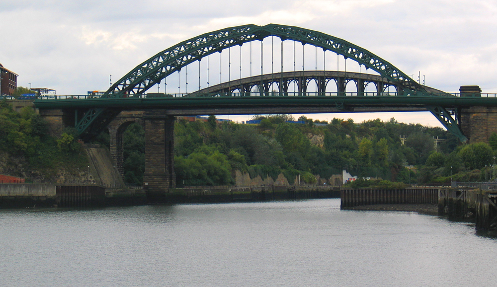
caption = The current Wearmouth Bridge - constructed in 1929. The bridge in the background is a railway bridge and is still in use.
official_name =
locale =Sunderland ,England
carries = Motor vehicles
"A183 road ,A1018 road "
Pedestrians
crosses =River Wear
maint =
open =1929
below = 105 ft
traffic =
design =compression arch suspended-deck bridge
toll =
mainspan = 375ft
length =
width = One two-lane carriageway) (southbound), Three carriageway (northbound), two cycle/footpaths (total 48 ft)The Wearmouth Bridge is acompression arch suspended-deck bridge across theRiver Wear inSunderland . It is the final bridge over the river before its mouth with theNorth Sea .The current bridge is the third Wearmouth Bridge in its position. The first opened in 1796, and then was reconstructed in the 19th century.
The first bridge
The first Wearmouth Bridge opened in 1796, with the foundation stone having been laid in September 1793. It was sponsored by Rowland Burdon, the MP. According to the plaque on the current bridge, its construction "proved to be a catalyst for the growth of Sunderland," since access between
Monkwearmouth andBishopwearmouth had previously only been by ferry, with the nearest bridge atChester-le-Street . There was originally a toll for traffic and pedestrians, although tolls for pedestrians were abolished in 1846.It was the second iron bridge built after the famous span at
Ironbridge , but was over twice as long with a nominal span of 240 feet, and only three-quarters the weight. Indeed, at the time of building, it was the biggest single span bridge in the world. It opened to traffic on9 August 1796 , having cost a total of about £28,000.cite web | work=Wearside Onliine | title= Sunderland Wearmouth Bridge |url= http://www.wearsideonline.com/Sunderland_Wearmouth_Bridge.html| accessdate=2006-09-24]1805 repair and 1857 reconstruction
In 1805 the bridge had to be repaired after heat from the sun caused some of the cross tubes to fall out.cite web | work= Local Studies Centre collection, Sunderland Public Library Service| title= LOCAL STUDIES CENTRE FACT SHEET NUMBER 7: The Wearmouth Bridge |url= http://www.sunderland.gov.uk/libraries/Leaflets/Wearmouth%20Bridge.pdf#search=%22wearmouth%20bridge%22| accessdate=2006-09-24]
From 1857 to 1859 it was reconstructed by
Robert Stephenson , who stripped the bridge back to its six iron ribs and levelled the hump in its middle by raising the abutments. The bridge was reopened in March 1859, with the toll completely abolished in 1885.The current bridge
To accommodate the growing volume of traffic, construction began on the current bridge in 1927. It was designed by Mott, Hay and Anderson and fabricated by the famous bridge building firm of
Sir William Arrol & Co. at their Dalmarnock Ironworks in Glasgow (they also built the famousForth Rail Bridge and the steel structure ofTower Bridge in London) ['The Sir William Arrol Collection', Royal Commission on the Ancient and Historical Monuments of Scotland contains many pictures of Wearside Bridge under Construction] . The new bridge was built around the old one to allow the road to remain open. It was opened on31 October 1929 by the Duke of York (who would later become King George VI).cite web |first=Alex |last=Vickers |work=National Grid for Learning |title=The second Wearmouth Bridge |url=http://localhistory.ngfl.gov.uk/discovery.php?id=350 |accessdate=2006-09-24]The cost of the bridge amounted to £231,943 of which £12,000 was spent on dismantling the old bridge.
It is described by
Nikolaus Pevsner , the recognised authority, as being of superb elegance.Fact|date=February 2007The adjoining railway bridge was built in 1879, and extended the railway south from Monkwearmouth to the centre of Sunderland. [cite web |work=Sunderland City Council |title=Historic Structures: Wearmouth Bridge |url=http://www.sunderland.gov.uk/Public/Editable/Themes/Visitors-Guide/Heritage/wearmouth-bridge.asp |accessdate=2006-09-24]
Further up the river, another bridge, the
Queen Alexandra Bridge , was completed in 1909, linking the areas ofPallion and Southwick. [cite web |title=SINE Project: Structure details for Queen Alexandra Bridge |work=University of Newcastle upon Tyne |url=http://sine.ncl.ac.uk/view_structure_information.asp?struct_id=1242 |accessdate=2006-10-12]The bridge carries the
A183 road betweenChester-le-Street andSouth Shields and theA1018 which was the old route of the A19 until the bypass was built leading to theTyne Tunnel .References
External links
* [http://www.tomorrows-history.com/CommunityProjects/PG0100060001/Wearmouth%20Bridge.htm Wearmouth Bridge over River Wear]
* [http://www.bbc.co.uk/wear/content/image_galleries/wearmouth_bridge_gallery.shtml Image gallery at BBC Wear]Crossings navbox
structure = Crossings
place =River Wear
bridge = Wearmouth Bridge
upstream =Wearmouth Rail Bridge
downstream = None
(North Sea )
Wikimedia Foundation. 2010.