- Marrah Mountains
-
Marrah Mountains Jebel Marra Range 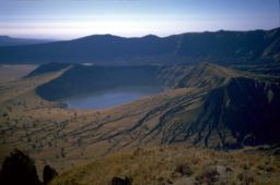 Inner and outer crater, Deriba Crater
Country Sudan Region Darfur Highest point Deriba crater - elevation 3,042 m (9,980 ft) - coordinates 12°57′00″N 24°16′12″E / 12.95°N 24.27°E Geology Volcanic field The Marrah Mountains or Marra Mountains (Jebel Marra, Arabic: جبل مرة bad mountains) is a range of volcanic peaks created by a massif that rises up to 3,000 m. It is located in the center of the Darfur region of Sudan, specifically within Dar Zagahawa and neighboring areas. The highest point is Deriba Caldera. The upper reaches of the massif is a small area of temperate climate with high rainfall and permanent springs of water.[1]
The last eruption occurred around 2000 BC. The centre of activity was Deriba Caldera, and involved caldera collapse following the eruption of pumice and pyroclastic flows which travelled over 30 kilometres (19 mi) from the volcano.[2]
See also
Footnotes
- ^ de Waal, Alex, Famine that Kills: Darfur, Sudan, Oxford University Press (Revised edition), 2005, ISBN 0-19-518163-8, p. 36
- ^ "Jebel Marra: Eruptive History". Global Volcanism Program, Smithsonian Institution. http://www.volcano.si.edu/world/volcano.cfm?vnum=0205-03-.
References
- "Jebel Marra". Global Volcanism Program, Smithsonian Institution. http://www.volcano.si.edu/world/volcano.cfm?vnum=0205-03-.
Major African geological formations Tectonic plates Cratons and Shields Arabian-Nubian Shield · Congo craton · Kaapvaal craton · Kalahari craton · Saharan Metacraton · Tanzania craton · Tuareg Shield · West African craton · Zimbabwe cratonShear zones Aswa Dislocation · Broodkop Shear Zone · Central African Shear Zone · Chuan Shear Zones · Foumban Shear Zone · Mwembeshi Shear Zone · Todi Shear Zone · Western Meseta Shear ZoneRifts Afar Depression · Anza trough · Bahr el Arab rift · Benue Trough · Blue Nile rift · East African Rift · Gulf of Suez Rift · Lamu Embayment · Melut Basin · Muglad Basin · Red Sea Rift · Atbara rift · White Nile riftSedimentary basins Angola Basin · Blue Nile Basin · Chad Basin · Congo Basin · Douala Basin · Foreland Karoo Basin · Gabon Basin · Iullemmeden Basin · Kufra Basin · Murzuq Basin · Niger Delta Basin · Ogaden Basin · Orange River basin · Owambo Basin · Reggane Basin · Rio del Rey Basin · Sirte Basin · Somali Coastal Basin · Taoudeni basin · Tanzania Coastal Basin · Tindouf BasinMountain ranges Aïr Mountains · Atlas Mountains · Aurès Mountains · Bambouk Mountains · Blue Mountains · Cameroon line · Central Pangean Mountains · Chaillu Mountains · Drakensberg · Ethiopian highlands · East African mountains · Great Escarpment · Great Karas Mountains · Guinée forestière · Imatong Mountains · Jebel Uweinat · Loma Mountains · Mandara Mountains · Marrah Mountains · Mitumba Mountains · Nuba Mountains · Rwenzori Mountains · Sankwala Mountains · Serra da Leba · Serra da Chela · Teffedest Mountains · Tibesti MountainsCategories:- Marrah Mountains
- Mountains of Sudan
- Volcanoes of Sudan
- Darfur
- Sudan geography stubs

Wikimedia Foundation. 2010.