- Rancho Petaluma Adobe
Infobox Historic building
name=Rancho Petaluma Adobe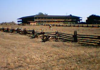
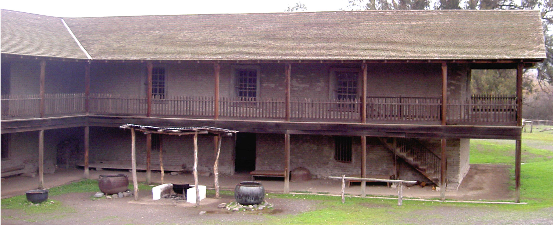
caption=Rancho Petaluma Adobe, California
map_type=
latitude=38.25547
longitude=-122.58451
location_town=east ofPetaluma, California
location_country=United States
architect=
client=General Mariano Guadalupe Vallejo
engineer=
construction_start_date=1834
completion_date=1857
date_demolished=
cost=$80,000
structural_system=adobe brick and timber
style=
size=200 x 145 feetInfobox_nrhp | name =Petaluma Adobe
nrhp_type = nhl
caption =
location = Casa Grande Road,Petaluma, California
locmapin = California
area =
built =1836
architect=
architecture=Adobe /Monterey Colonial [http://tps.cr.nps.gov/nhl/detail.cfm?ResourceID=909&resourceType=Building NHL Summary] ]
added =April 15 ,1970
designated =April 15 ,1970
governing_body = State
refnum=70000151cite web|url=http://www.nr.nps.gov/|title=National Register Information System|date=2008-04-15|work=National Register of Historic Places|publisher=National Park Service]Rancho Petaluma Adobe is the name of a historic
ranch and adoberanch house that was owned and constructed by GeneralMariano Guadalupe Vallejo , commandant of the Sonoma Pueblo [http://www.nr.nps.gov/Red%20Books/70000151.red.pdf NPS Redbook] ] from 1834 to 1857. It is the largest example of theMonterey Colonial style of architecture in the United States. [http://www.nr.nps.gov/writeups/70000151.nl.pdf NHL Writeup] ] It has been preserved by the Petaluma Adobe State Historic Park as a state andNational Historic Landmark . The Rancho Petaluma Adobe is located on Adobe Road on the east side of present-day town ofPetaluma, California . The park is threatened with closure.Description
The Petaluma Adobe ranch house was the largest privately owned adobe building ever built in California. It was two stories high, built in a quadrangle roughly 200 x 145 ft (61 x 44 m), two buildings surrounding an open courtyard
patio . The eastern building no longer exists, so it is only half its former size. It took 10 years and thousands of local adobe bricks to make. [Department of Parks & Recreation, 1987:8.] It was detailed with imported glass windows in the downstairs dining room, interior fireplaces, planked floors, a low sloped shingled roof, and a two story wooden veranda that encased and protected the adobe walls. The combination of wood and adobe is unique to Mexican-American architecture. [ Department of Parks & Recreation, 1987:10.]History
Mexican-American era
In 1834, Governor
José Figueroa granted General Vallejo the lands of "Rancho Petaluma". In 1836, General Vallejo began construction of the ranch house in 1836, investing an estimated $80,000 in men, materials and years to complete. His younger brotherSalvador Vallejo directed most of the construction. Between 1836 and 1839, at least 2,000 Native Americans were employed at the ranch construction to make bricks, haul lumber, construct, cook, farm, make tools, tan hides and tend a large herd of cattle.From the ranch, the General lodged soldiers who kept peace in the region, and conducted ranch business. His family often used the Petaluma Adobe as a summer home, while he resided in the neighboring town of
Sonoma, California . He left daily management to his "mayordomo" (foreman), Miguel Alvarado, who resided at the ranch.In its operational days between 1836 and 1857, the Rancho Petaluma employed up to 2,000 of the remaining Sonoma County Native Americans. Quickly, the cattle ranch became one of the largest Mexican-American owned ranches of the north bay and a social-economic center of Northern California.
The ranch included a tannery, smithy, and
grist mill . It had over 12,000 head of cattle, one quarter slaughtered each year for the main exports ofhides andtallow sent via river boats on thePetaluma River down to theSan Francisco Bay . The export of hides and tallow was its main income source, a very lucrative business in the Mexican-American era, while much of the meat was wasted. Vallejo made an estimate $18,000 to $24,000 yearly on hides and tallow. Necessities and other products such as candles, soap, thousands of wool blankets, boots and shoes for military troops under Vallejo’s command, and saddles were manufactured by native artisans in shops. [data from Department of Parks & Recreation, 1987:12, 26.]In 1844, Governor
Pío Pico deeded to General Vallejo 66,000acre s (270 km²) on behalf of the country ofMexico , in a grant called the "Rancho Soscol", adding and extending the ranch lands considerably, to reward Vallejo's military services. "Rancho Soscol" extended the lands of Rancho Petaluma south down to theSan Francisco Bay , and southwest to present-day city of Vallejo, and includes the region of present-day town of Petaluma.Native American tenants
After the
Spanish missions in California weresecularized in 1834, many Native Americans of the region, theSuisunes ,Coast Miwok and Pomo, sought employment on the large ranches ofNorthern California . The Rancho Petaluma as the largest ranch employed the majority of the Native Americans in the County. Many Native Americans were recruited as ex-neophytes of the disbandedMission San Francisco Solano (the Sonoma Mission) who needed a new employer and were trained ranch people already, others were employed after being captured by force during military skirmishes. Some natives joined from military and political alliances with Vallejo, and others because it was social-economic center especially as a place of seasonal work. In apatron arrangement that recalls the preceding mission system, many of the natives turned over all of their own cattle to Vallejo, in exchange to become a part of the ranch as the worker force and tenants. Many constructed huts of tule reeds and lived beside the ranch. In payment for working on the ranch as ranchers, cattlemen, artisans and servants, the Natives received some protection, daily food and clothing. However unlike the Mission Indians, the Natives at the ranch were not expected to beRoman Catholic or follow strict Catholic practices. [Silliman, 2004:55-58.]Decline of 1846-1910
The fate of the ranch turned in 1846-1848 when the
United States and Mexico went to war: General Vallejo was imprisoned for his position in the Mexican military, and in his absence,John C. Frémont requisitioned and stripped the ranch of its horses, cattle and grain reserves for his California battalion. Many of the natives, his main labor force, had fled from the incoming gold rush settlers. Thereafter the ranch declined in value and profitability for Vallejo every year. The University of California considered purchasing it for a campus site in 1856. Vallejo sold the building and 1,600 acres (65 km²) to William Whiteside for $25,000 circa 1857 who sold it to William Bliss. The southeast half of the adobe deteriorated and the Bliss family could not afford all the repairs. [Department of Parks & Recreation, 1987:18, 32.]Conversion to a historic park
In 1910, the Petaluma Adobe was bought by the
Native Sons of the Golden West . In 1932 it was registered as California State Historical Landmark #18. In 1951, the ranch was sold to theState of California . In 1970, it was registered as a National Historic Landmark. It is now preserved as the centerpiece of Petaluma Adobe State Historic Park.Citation | title=Petaluma Adobe State Historic Park | date=2005 | publisher=Petaluma Adobe State Historic Park]Locals refer to it as "Old Adobe."
Proposed for closure
Petaluma Adobe State Historic Park is is one of the 48 California state parks proposed for closure in January 2008 by California's Governor
Arnold Schwarzenegger as part of a deficit reduction program. [ [http://cbs5.com/local/California.parks.budget.2.627476.html CBS5.com: List Of Calif. Parks To Close In Budget Proposal] ]References
*cite book | last=California | first=Department of Parks & Recreation | coauthors= | title=Petaluma Adobe State Historic Park General Plan | location=Sacramento, CA | publisher=State of California Resources Agency| year=1987 | oclc=38627251
*cite book | last=Silliman | first=Stephen | title=Lost Laborers in Colonial California, Native Americans and the Archaeology of Rancho Petaluma | location=Tucson, AZ | publisher=University of Arizona Press | year=2004 | isbn=0816523819
* [http://www.parks.sonoma.net/adobe.html Sonomanet: Parks and Recreation in Sonoma County. "Petaluma Adobe State Historic Park"] . Retrieved 2006-09-04.External links
* [http://www.parks.sonoma.net/adobe.html Official Site]
* [http://www.nps.gov/history/nr/travel/ca/ Early History of the California Coast, a National Park Service "Discover Our Shared Heritage" Travel Itinerary]ee also
*
Alta California
*Californios
Wikimedia Foundation. 2010.