- Manila galleon
-
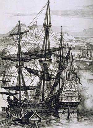
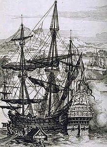 Spanish Galleon
The Manila galleons or Manila-Acapulco galleons (Spanish: Galeones de Manila-Acapulco) were Spanish trading ships that sailed once or twice per year across the Pacific Ocean between Manila in the Philippines, and Acapulco, New Spain (present-day Mexico). The name changed reflecting the city that the ship was sailing from.[1] Service was inaugurated in 1565 with the discovery of the ocean passage by Andrés de Urdaneta, and continued until 1815 when the Mexican War of Independence put a permanent stop to the galleon trade route.
Contents
Discovery of the route
In 1521 Magellan was blown west across the Pacific by the trade winds. The problem was to go east. The first ship to try this failed. In 1529 Álvaro de Saavedra Cerón also failed. In 1543 Bernardo de la Torre failed. The Manila-Acapulco galleon trade began when Andrés de Urdaneta, sailing in convoy under Miguel López de Legazpi, discovered a return route from Cebu City to Mexico in 1565. Attempting to return, the fleet split up, with part of it heading south. Urdaneta reasoned that the trade winds of the Pacific might move in a gyre as the Atlantic winds did. If in the Atlantic ships made a wide swing (the "volta") to the west to pick up winds that would bring them back from Madeira, then, he reasoned, by sailing far to the north before heading east he would pick up westerlies to bring him back to the west coast of North America.
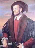 Andrés de Urdaneta
Though he sailed to 38 degrees North before turning east, his hunch paid off, and he hit the coast near Cape Mendocino, California, then followed the coast south to San Blas and later to Acapulco.[2] Most of his crew died on the long initial voyage, for which they had not sufficiently provisioned.
By the 18th century it was understood that a less northerly track was sufficient, but galleon navigators steered well clear of the forbidding and rugged fogbound California coast; According to historian William Lytle Schurz, "They generally made their landfall well down the coast, somewhere between Point Conception and Cape San Lucas...After all, these were preeminently merchant ships, and the business of exploration lay outside their field, though chance discoveries were welcomed".[3]
The first motivation for exploration of Alta California was to scout out possible way-stations for the seaworn Manila galleons on the last leg of their journey. Early proposals came to little, but in the later 18th century several Manila galleons put in at Monterey.
Spice trade
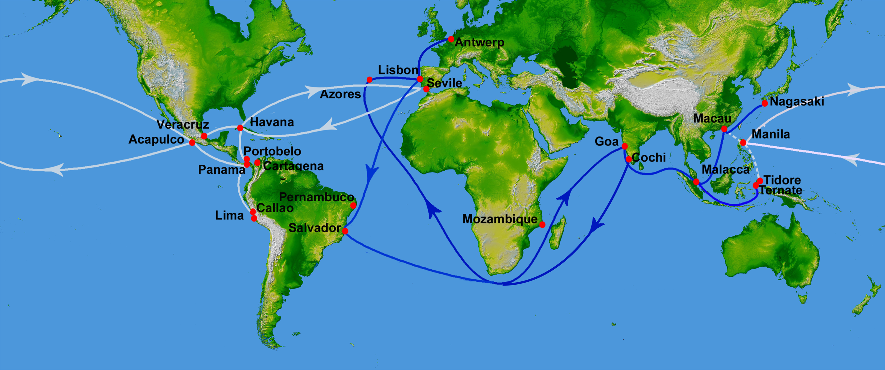
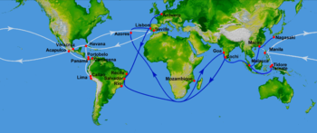 The Manila-Acapulco trade route started in 1568 and Spanish treasure fleets (white) and its eastwards rivals, the Portuguese India Armadas routes of 1498-1640 (blue)
Trade served as the fundamental source of income for Spanish colonists in the Philippine Islands. A total of 110 Manila galleons set sail in the 250 years of the Manila-Acapulco galleon trade (1565 to 1815). Until 1593, three or more ships would set sail annually from each port. The Manila trade was becoming so lucrative that Seville merchants petitioned king Philip II of Spain to protect the monopoly of the Casa de Contratación based in Seville. This led to the passing of a decree in 1593 that set a limit of two ships sailing each year from either port, with one kept in reserve in Acapulco and one in Manila. An "armada" or armed escort of galleons, was also approved.
With such limitations it was essential to build the largest possible galleons, which were the largest class of ships known to have been built anywhere up to that time.[4] In the 16th century, they averaged from 1,700 to 2,000 tons, were built of Philippine hardwoods and could carry a thousand passengers. The Concepción, wrecked in 1638, was 43 to 49 m (140–160 feet) long and displacing some 2,000 tons. The Santísima Trinidad was 51.5 m long. Most of the ships were built in the Philippines and only eight in Mexico. The Manila-Acapulco galleon trade ended in 1815, a few years before Mexico gained independence from Spain in 1821. After this, the Spanish Crown took direct control of the Philippines, and was governed directly from Madrid. This became manageable in the mid-19th century upon the invention of steam power ships and the opening of the Suez Canal, which reduced the travel time from Spain to the Philippines to 40 days.
The galleons carried spices, porcelain, ivory, lacquerware, processed silk cloth gathered from both the Spice Islands, and Asia-Pacific, to be sold in the Americas, namely New Spain and Peru as well as in European markets. East Asia trading was primarily on a silver standard; the goods were mostly bought by Mexican silver. The cargoes were transported by land across Mexico to the port of Veracruz on the Gulf of Mexico, where they were loaded onto the Spanish treasure fleet bound for Spain. This route was the alternative to the trip west across the Indian Ocean, and around the Cape of Good Hope, which was reserved to Portugal according to the Treaty of Tordesillas. It also avoided stopping over at ports controlled by competing powers, such as Portugal and the Netherlands. From the early days of exploration, the Spanish knew that the American continent was much narrower across the Panamanian isthmus than across Mexico. They tried to establish a regular land crossing there, but the thick jungle, and malaria made it impractical.
It took at least four months to sail across the Pacific Ocean from Manila to Acapulco, and the galleons were the main link between the Philippines and the viceregal capital at Mexico City and thence to Spain itself. Many of the so-called "Kastilas" or Spaniards in the Philippines were actually of Mexican descent, and the Hispanic culture of the Philippines is somewhat close to Mexican culture.[5] Even after the galleon era, and at the time when Mexico finally gained its independence, the two nations still continued to trade, except for a brief lull during the Spanish-American War. The Manila galleons sailed the Pacific for two hundred and fifty years, bringing to Spain their cargoes of luxury goods, economic benefits, and cultural exchange.
The wrecks of the Manila galleons are legends second only to the wrecks of treasure ships in the Caribbean. In 1568, Miguel López de Legazpi's own ship, the San Pablo (300 tons), was the first Manila galleon to be wrecked en route to Mexico. Between the years 1576 when the "Espiritu Santo" was lost and 1798 when the "San Cristobal(2)" was lost there were twenty Manila Galleons [1] wrecked within the Philippine archepelago. In 1587 a Manila galleon was captured by Thomas Cavendish and in 1743 by George Anson, 1st Baron Anson.
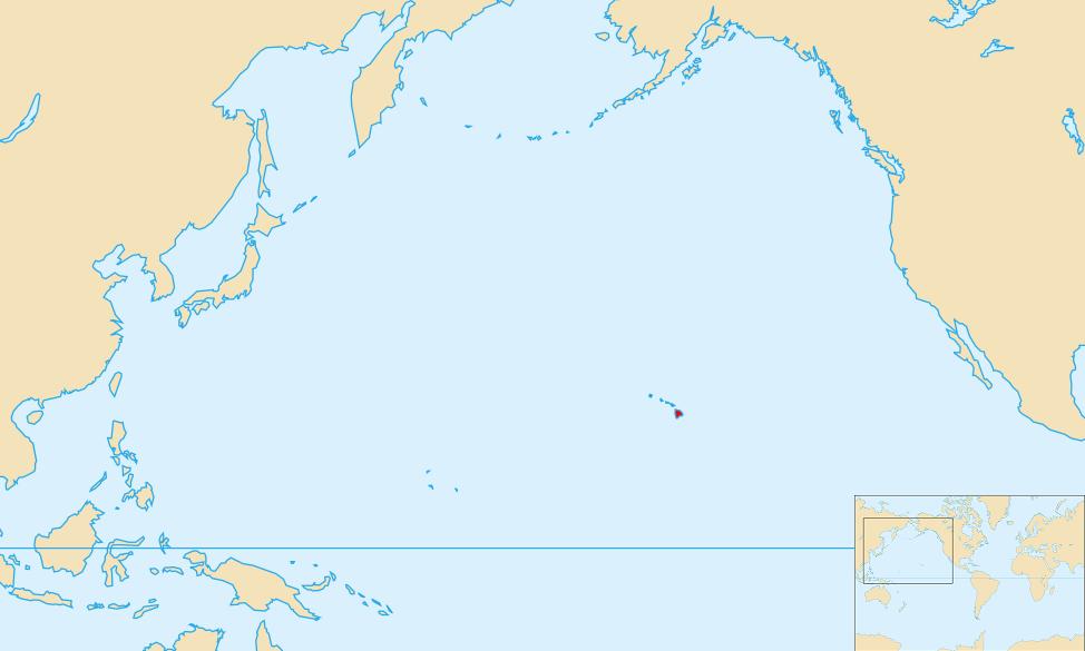
Hawaii
For 250 years, hundreds of Manila galleons traveled from present-day Mexico to the Philippines, with their route taking them south of the Hawaiian Islands. And yet, no historical records of any contact between the two cultures exist. British historian Henry Kamen maintains that the Spanish did not have the ability to properly explore the Pacific Ocean, and were not capable of finding the islands which lay at a latitude 20° north of the galleon route and their currents.[6] However, Spanish activity in the Pacific was paramount until the late 18th century. Navigator Urdaneta was the first to sail the Pacific from west to east, establishing the maritime route from Asia to America in 1565, that lasted until 1815. Spanish expeditions discovered Guam, the Marianas, the Carolines and the Philippines in the North Pacific, as well as Tuvalu, the Marquesas, the Solomon Islands and New Guinea in the South Pacific. Spanish navigators also discovered the Pitcairn and Vanuatu archipelagos during their search for Terra Australis in the 17th century.
There are questions as to whether Spanish explorers did arrive in the Hawaiian Islands two centuries before Captain James Cook's first visit in 1778. Ruy López de Villalobos commanded a fleet of six ships that left Acapulco in 1542 with a Spanish sailor named Juan Gaetano aboard as pilot. Depending on the interpretation, Gaetano's reports seemed to describe the discovery of Hawaii or the Marshall Islands in 1555.[7] If it was Hawaii, Gaetano would have been one of the first Europeans to find the islands. Most scholars have dismissed these claims as lacking credibility.[8][9]
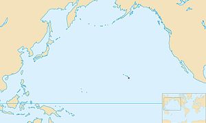 Pacific Ocean with Mauna Kea highlighted.
After 1565, Andrés de Urdaneta's new route allowed Manila galleons to sail regularly between Mexico and the Philippines for two and a half centuries, ending in 1815. The westward route from Mexico passed south of Hawaii, making a short stopover in Guam before heading for Manila. The exact route was kept secret to protect the Spanish trade monopoly against competing powers, and to avoid Dutch and English pirates. Due to this policy of discretion, if the Spanish did find Hawaii during their voyages, they would not have published their findings and the discovery would have remained unknown. From Gaetano's account, the Hawaiian islands were not known to have any valuable resources, so the Spanish would have not made an effort to settle them.[7] This happened in the case of the Mariana and Caroline Islands, which were not effectively settled until the second half of the 17th century. Spanish archives contain a chart that depicts islands in the latitude of Hawaii but with the longitude ten degrees east of the Islands. In this manuscript, the Island of Maui is named "La Desgraciada" (the disgraced), and what appears to be the Island of Hawaii is named "La Mesa" (the table). Islands resembling Kahoolawe, Lanai, and Molokai are named "Los Monjes" (the monks).[10]
William Ellis, a writer and missionary in early 19th century Hawaii, recorded several folk stories about foreigners who had visited Hawaii prior to first contact with Cook. According to Hawaiian writer Herb Kawainui Kane, one of these stories:
concerned seven foreigners who landed eight generations earlier at Kealakekua Bay in a painted boat with an awning or canopy over the stern. They were dressed in clothing of white and yellow, and one wore a sword at his side and a feather in his hat. On landing, they kneeled down in prayer. The Hawaiians, most helpful to those who were most helpless, received them kindly. The strangers ultimately married into the families of chiefs, but their names could not be included in genealogies.[7]
Debate continues as to whether the Hawaiian Islands were actually visited by the Spanish in the 16th century[11] with researchers like Richard W. Rogers looking for evidence of Spanish shipwrecks.[12][13]
See also
- Battles of La Naval de Manila
- History of the Philippines (1521-1898)
- History of the west coast of North America
- Spanish East Indies
- Spanish treasure fleet
- Bernardo de la Torre
References
- ^ Williams, Glyn. 1999. The Prize of All the Oceans. Viking, New York. ISBN 0-670-89197-5, p. 4
- ^ Derek Hayes (2001). Historical atlas of the North Pacific Ocean: maps of discovery and scientific exploration, 1500-2000. Douglas & McIntyre. p. 18. ISBN 9781550548655. http://books.google.com/books?id=0Z26YL407SkC&pg=PA152&lpg=PA152&dq=sailing+historic+use+of+trade+winds+book#v=onepage&q=&f=false. Retrieved 2009-11-08.
- ^ Schurz 1917, p.107-108
- ^ See Treasure Ship for Chinese vessels that might have been larger.
- ^ Guevarra, Rudy P. (2007). Mexipino: A history of multiethnic identity and the formation of the Mexican and Filipino communities of San Diego, 1900--1965. University of California, Santa Barbara. ISBN 0549122869
- ^ Kamen, Henry (2004). Empire: How Spain Became a World Power, 1492-1763. HarperCollins. ISBN 0060932643.
- ^ a b c Kane, Herb Kawainui (1996). "The Manila Galleons". In Bob Dye. Hawaiʻ Chronicles: Island History from the Pages of Honolulu Magazine. I. Honolulu: University of Hawaii Press. pp. 25–32. ISBN 0-8248-1829-6.
- ^ By Oliver, Douglas L. (1989). The Pacific Islands. University of Hawaii Press. p. 45. ISBN 0824812336
- ^ Coulter, John Wesley. (Jun, 1964) "Great Britain in Hawaii: The Captain Cook Monument". The Geographical Journal, Vol. 130, No. 2. doi:10.2307/1794586
- ^ Hawaii National Park. (June 1959). "Hawaii Nature Notes". The Publication of the Naturalist Division, Hawaii National Park, and the Hawaii Natural History Association.
- ^ Horwitz, Tony. (2003). Blue Latitudes: Boldly Going Where Captain Cook Has Gone Before. p.452. ISBN 03124226
- ^ Rogers, Richard W. (1999). Shipwrecks of Hawaii: A Maritime History of the Big Island. Pilialoha Press
- ^ "Perhaps the leading authority on Hawaiian shipwrecks today", writes Peter von Buol, referring to Richard W. Rogers in the Fall 2006, Vol. 38, No. 3 issue of Prologue, published by the NARA.
Further reading
- Schurz, William Lytle. (1917) "The Manila Galleon and California", Southwestern Historical Quarterly, Vol. 21, No. 2, pp. 107–126
- Schurz, William Lytle. The Manila Galleon. New York: E. P. Dutton & Co., Inc., 1939.
External links
- Findings from the wreck of Nuestra Senora de la Concepcion in the Marianas, 1638
- Metropolitan Museum: Manila Galleon
- Manila Galleons along the Californian coasts
- Asociación Cultural Galeón de Manila, Spanish-Philippine research group based in Madrid (in Spanish)
Categories:- Spanish East Indies
- Spanish colonial period in the Philippines
- Spanish colonization of the Americas
- Spanish Navy
- Naval warfare
- History of the Pacific Ocean
- Colonial Mexico
- Shipping routes
- Ship types
- New Spain
- 1565 establishments
- 1815 disestablishments

Wikimedia Foundation. 2010.