- Montauk Airport
-
Montauk Airport 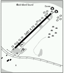
IATA: MTP – ICAO: KMTP Summary Airport type Public Operator Montauk Airport Inc. Location Montauk, New York Elevation AMSL 6 ft / 1.8 m Coordinates 41°04′36″N 71°55′13.7″W / 41.07667°N 71.920472°WCoordinates: 41°04′36″N 71°55′13.7″W / 41.07667°N 71.920472°W Runways Direction Length Surface ft m 6/24 3,246 989 Asphalt Montauk Airport (IATA: MTP, ICAO: KMTP) is a public airport located on East Lake Drive between Lake Montauk and Block Island Sound, approximately 3 miles (4.8 km) northeast of Montauk, in Suffolk County, New York, USA. Montauk Airport is the easternmost airport in New York State.[1]
Contents
History
Montauk Airport was constructed in 1957 to improve access to the East End community, which was being developed as a summer resort.[2] Perry Duryea Jr., a former pilot of the Naval Air Transport Service, was one of the early partners of the corporation that developed the airport, and often piloted his own plane between Montauk and Albany while serving as a member of the New York State Assembly.[3][4] The following year, regular flights were proposed between Montauk and LaGuardia Airport in New York City during the summer season for use by vacationers and sport fishermen.[5]
In 2007, Montauk Airport received two grants from the Federal Aviation Administration to install an Automated Weather Observing System to provide pilots with current weather conditions at the airport and a Precision Approach Path Indicator to visually alert pilots if they are on the glidepath while preparing to land.[6] An additional grant was received from the FAA in 2008 to install taxiway edge lights.[7]
Facilities
Montauk Airport covers 40 acres (16 ha) and has one runway:
- Runway 6/24: 3,246 x 75 ft (989 x 23 m), Surface: Asphalt
Incidents
- On March 7, 2009, a Cirrus SR22 went off the runway and burst into flames while practicing a takeoff from the Montauk Airport. The student pilot and instructor escaped from the aircraft without injuries.[8]
- On July 31, 2007, a Piper PA-28-181 crashed into trees at the Montauk Airport after aborting a landing and attempting a go-around. The pilot was uninjured and rescued by an airport employee and two people from a nearby beach.[9]
- On July 7, 2003, a Piper PA-34-200T crashed into the waters of Big Reed Pond in Montauk County Park after taking off from the Montauk Airport, killing the pilot and two passengers. The men had gone out earlier in the evening on a fishing trip for striped bass and were flying back to Republic Airport during the middle of the night. The plane was discovered the next morning by a family canoeing in the pond.[10]
References
- ^ Federal Aviation Administration (October 27, 2005). CF-19 (Map). 1:1,000,000. World Aeronautical Chart (35th ed.).
- ^ "Work to Start Soon On Montauk Airport". The New York Times. September 29, 1957. http://select.nytimes.com/gst/abstract.html?res=F40616F93854157A93CBAB1782D85F438585F9. Retrieved 2009-08-30.
- ^ Drumm, Russell (January 15, 2004). "Perry Duryea, Lobsterman, Leader: Montauker Went to Albany, Was Republican Candidate for Governor in 1978". The East Hampton Star. http://easthamptonstar.com/DNN/Archive/2004/20040115/news3.htm. Retrieved 2009-08-30.
- ^ Molotsky, Irvin (June 18, 1978). "Long Island Journal". The New York Times. http://select.nytimes.com/gst/abstract.html?res=FA0F13F8345413718DDDA10994DE405B888BF1D3. Retrieved 2009-10-12.
- ^ "Airline to Offer Montauk Service". The New York Times. April 20, 1958. http://select.nytimes.com/gst/abstract.html?res=FA0A14F63955117A93C2AB178FD85F4C8585F9. Retrieved 2009-10-12.
- ^ "Bishop Announces $75,000 Worth of Grants for Montauk Airport Safety" (Press release). Congressman Tim Bishop. July 26, 2007. http://timbishop.house.gov/index.cfm?sectionid=79&parentid=3§iontree=&itemid=1064. Retrieved 2009-08-30.
- ^ "Bishop Announces $67,000 Grant for Safety Lighting at Montauk Airport" (Press release). Congressman Tim Bishop. June 11, 2008. http://timbishop.house.gov/index.cfm?sectionid=79&parentid=3§iontree=&itemid=1344. Retrieved 2009-08-30.
- ^ Drumm, Russell (March 7, 2009). "Plane Skids Off Runway, Instructor and Student Pilot Uninjured". The East Hampton Star. http://www.easthamptonstar.com/dnn/Archive/Home20090305/News/MontaukPlaneSkidsOffRunway/tabid/8151/Default.aspx. Retrieved 2009-08-30.
- ^ Hewitt, Janis (August 2, 2007). "Crash Landing at Airport; Federal Grants". The East Hampton Star. http://www.easthamptonstar.com/dnn/Archive/Home20080807/News/PlaneCrash/tabid/3146/Default.aspx. Retrieved 2009-08-30.
- ^ Hewitt, Janis (July 11, 2003). "Cause Unknown As Flight Home Ends in Pond. Three Men Killed in Mysterious Descent". The East Hampton Star. http://easthamptonstar.com/DNN/Archive/2003/20030711/news1.htm. Retrieved 2009-08-30.
External links
- New York State DOT Airport DiagramPDF
- Resources for this airport:
- AirNav airport information for KMTP
- ASN accident history for MTP
- FlightAware airport information and live flight tracker
- NOAA/NWS latest weather observations
- SkyVector aeronautical chart, Terminal Procedures for KMTP
Categories:- Airports on Long Island
- Airports established in 1957
- East Hampton (town), New York
- Transportation in Suffolk County, New York

Wikimedia Foundation. 2010.