- New York State Route 240
-
NYS Route 240
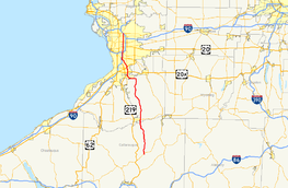
Map of the Buffalo area with NY 240 highlighted in redRoute information Maintained by NYSDOT, Cattaraugus County, and Erie County Length: 51.64 mi[2] (83.11 km) Existed: 1930[1] – present Major junctions South end:  NY 242 in Ashford
 US 20A in Orchard Park
 US 20 in Orchard Park
 NY 400 in West Seneca
 NY 33 in Cheektowaga
North end: 
 I-290 / NY 324 in Amherst
Location Counties: Cattaraugus, Erie Highway system Numbered highways in New York
Interstate • U.S. • N.Y. (former) • Reference • County←  NY 239
NY 241  →
→New York State Route 240 (NY 240) is a 51.64-mile (83.11 km) state highway in western New York in the United States. The southern terminus of the route is at an intersection with NY 242 in the Ellicottville community of Ashford in northern Cattaraugus County. Its northern terminus is at a junction with NY 324 and Interstate 290 (I-290) in Amherst in northern Erie County. The route passes through the villages of Springville and Orchard Park, where it meets NY 39 and U.S. Route 20A (US 20A), respectively. Much of NY 240 between Concord and Aurora follows the west branch of Cazenovia Creek. The northern part of NY 240 in Erie County, named Harlem Road, is a major north–south route through the suburbs east of the city of Buffalo.
From its southern terminus at NY 242 to the hamlet of Glenwood in the town of Colden, NY 240 is a state highway in name only as the roadway is maintained by the highway departments of Cattaraugus and Erie Counties. Within Cattaraugus County, NY 242 is co-designated as County Route 32 (CR 32). CR 32 is the only route that has a marked concurrency with a state route in the county. At the county line, it becomes County Route 198 and, later, County Route 30 before becoming state-maintained in Glenwood.
Contents
Route description
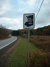 The lone Erie County Route 30 shield along NY 240 in Orchard Park
NY 240 begins at an intersection with NY 242 in the community of Ashford. NY 240, concurrent to CR 32 throughout Cattaraugus County, continues to the north as West Valley Road. As NY 240 passes over Cattaraugus Creek and enters Erie County, it becomes known as Vaughn Street.
In the village of Springville, NY 240 intersects with NY 39 (East Main Street). At its intersection with Genesee Road in East Concord, it briefly follows Allen Road to the northeast before splitting to the northwest as Glenwood – East Concord Road. In Glenwood, NY 240 becomes State Road then, in West Falls, Davis Road upon passing Knapp Road. At Ellicott Road, NY 240 turns west, following the roadway to the vicinity of Orchard Park. At Powers Road south of the village, NY 240 turns northwest, following Ellicott Road to an intersection with NY 277 (Chestnut Ridge Road). NY 240 merges with NY 277, forming a concurrency into Orchard Park. The two routes become known as Buffalo Road through the village of Orchard Park, meeting US 20A (Quaker Street) in the middle of the village. North of the village in the town of Orchard Park, NY 240 and NY 277 intersect Mile Strip Road, a major east–west arterial during Buffalo Bills home games. To the north of Mile Strip is US 20 (Southwestern Boulevard), followed by the split of the concurrency just north of US 20. While NY 277 (Union Road) heads due north, NY 240 turns northwest and becomes Orchard Park Road.
Now in the town of West Seneca, NY 240 meets NY 16 (Seneca Street), where it becomes known as Harlem Road for the remainder of its routing. After traversing NY 400 (the Aurora Expressway) with no connection to the freeway, NY 240 intersects NY 354 (Clinton Street) near Cheektowaga. The route then passes underneath the New York State Thruway (I-90) with no connection and enters Cheektowaga.
 Rotaries near the Cheektowaga–Amherst town line
Just outside of the Cheektowaga village of Sloan, NY 240 connects to NY 130 (Broadway) by way of an interchange in the shadow of the CSX Transportation-owned Frontier Yard, the largest railroad yard in the city. NY 240 continues north, passing over the CSX Buffalo Terminal Subdivision and intersecting Walden Avenue northeast of the yard and northwest of the Walden Galleria. To the north of the mall and west of the Buffalo Niagara International Airport, NY 240 intersects both the former routing of NY 33 at Genesee Street and its current routing slightly north of Genesee on the Kensington Expressway.
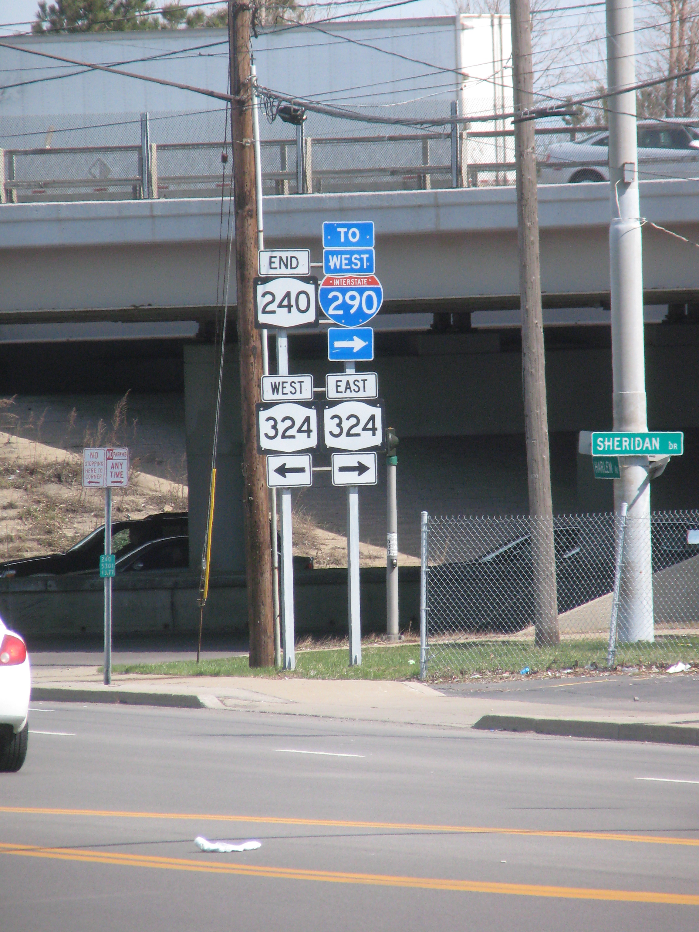
 Northern terminus of NY 240 in Amherst
North of the expressway, NY 240 passes through a series rotaries near the Cheektowaga town line with Amherst in the hamlet of Snyder. Then, NY 240 enters the heart of Amherst where it intersects the Snyder business district, meeting NY 5 (Main Street). Heading north, NY 240 continues onward to its northern terminus at the intersection of NY 324 (Sheridan Drive) and I-290 (Youngmann Expressway) in Amherst.
History
NY 240 was assigned as part of the 1930 renumbering of state highways in New York to an alignment extending from NY 39 east of Springville to NY 18 southeast of downtown Buffalo. Instead of turning north onto Harlem Road as it does today, NY 240 continued northwest on Potter and Abbott Roads to South Park Avenue (then NY 18). At the time, the portion of modern NY 240 south of Cattaraugus Street in Springville was designated as part of NY 62 while the portion south of Cattaraugus County Route 16 in West Valley was also part of NY 242.[1] NY 242 was moved onto its modern routing between Ashford and Machias by the following year while NY 62 was mostly renumbered to NY 75 ca. 1932.[3][4]
US 219 was extended into New York ca. 1935,[5][6] overlapping NY 75 between Ashford and Springville.[7] The overlap with NY 75 was eliminated by 1940 when NY 75 was truncated northward to US 62 in Hamburg.[8] In the mid-1950s, US 219 was shifted westward onto a new highway between Ellicottville and Springville;[9][10] however, NY 240 was not extended south to Ashford over its former routing until the mid-1960s.[11][12] In the Buffalo area, NY 240 was extended northwestward along South Park Avenue to Main Street, which carried NY 5 at the time, in the late 1930s.[7][13] Ca. 1962, it was altered to follow Harlem Road across Cazenovia Creek to Seneca Street, where it ended at NY 16.[14][15] NY 240 was extended northward along Harlem Road to NY 324 in Amherst in the mid-1960s.[11][12] The portion of NY 240's former routing on Potter Road between the Buffalo city line and Harlem Road is now NY 950M, an unsigned reference route.[16]
Major intersections
County Location Mile[2] Destinations Notes Cattaraugus Ashford 0.00 NY 242Erie Springville 14.13  NY 39
NY 39Town of Orchard Park 34.90  NY 277 south
Southern terminus of NY 240 / NY 277 overlap Village of Orchard Park 36.20 US 20ATown of Orchard Park 38.26 US 2038.51 NY 277 northNorthern terminus of NY 240 / NY 277 overlap West Seneca 42.24  NY 16 to NY 400
44.22  NY 354
Cheektowaga 46.25  NY 130
47.76 Genesee Street (NY 952A) Formerly NY 33B 48.50 NY 33Amherst 50.60  NY 5
NY 551.64 I-290 / NY 324Exit 6 (I-290) 1.000 mi = 1.609 km; 1.000 km = 0.621 mi References
- ^ a b Standard Oil Company of New York (1930). Road Map of New York (Map). Cartography by General Drafting.
- ^ a b "2008 Traffic Volume Report for New York State" (PDF). New York State Department of Transportation. June 16, 2009. pp. 194–195. https://www.nysdot.gov/divisions/engineering/technical-services/hds-respository/NYSDOT%20TVR%202008%20by%20Route.pdf. Retrieved February 1, 2010.
- ^ Kendall Refining Company (1931). New York (Map). Cartography by H.M. Gousha Company.
- ^ Texas Oil Company (1932). Texaco Road Map – New York (Map). Cartography by Rand McNally and Company.
- ^ Texas Oil Company (1934). Road Map of New York (Map). Cartography by Rand McNally and Company.
- ^ Sun Oil Company (1935). Road Map & Historical Guide – New York (Map). Cartography by Rand McNally and Company.
- ^ a b Esso (1938). New York Road Map for 1938 (Map). Cartography by General Drafting.
- ^ Gulf Oil Company (1940). New York Info-Map (Map). Cartography by Rand McNally and Company.
- ^ Esso (1954). New York with Special Maps of Putnam–Rockland–Westchester Counties and Finger Lakes Region (Map). Cartography by General Drafting (1955–56 ed.).
- ^ Esso (1956). New York with Special Maps of Putnam–Rockland–Westchester Counties and Finger Lakes Region (Map). Cartography by General Drafting (1957 ed.).
- ^ a b Mobil (1965). New York (Map). Cartography by Rand McNally.
- ^ a b Esso (1968). New York (Map). Cartography by General Drafting (1969–70 ed.).
- ^ Esso (1940). New York (Map). Cartography by General Drafting.
- ^ Sunoco (1961). New York and Metropolitan New York (Map). Cartography by H.M. Gousha Company (1961–62 ed.).
- ^ Esso (1962). New York with Sight-Seeing Guide (Map). Cartography by General Drafting (1962 ed.).
- ^ New York State Department of Transportation (January 2009) (PDF). Official Description of Highway Touring Routes, Bicycling Touring Routes, Scenic Byways, & Commemorative/Memorial Designations in New York State. https://www.nysdot.gov/divisions/operating/oom/transportation-systems/repository/2009%20tour-bk.pdf. Retrieved May 9, 2010.
External links
Categories:- State highways in New York
- Transportation in Erie County, New York
- Transportation in Cattaraugus County, New York


Wikimedia Foundation. 2010.