- Duchy of Brabant
-
Duchy of Brabant
Hertogdom Brabant (nl)
Duché de Brabant (fr)State of the Holy Roman Empire 1183–1648 
Coat of arms
The Duchy of Brabant around 1350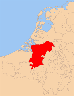
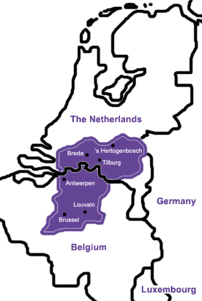
Capital Brussels Government Principality Historical era Middle Ages, Renaissance - Established 1183 - Inherited by Burgundy 1430 - Inherited by the House of Habsburg 1477 - Disestablished 1648 The Duchy of Brabant was a historical region in the Low Countries. Its territory consisted essentially of the three modern-day Belgian provinces of Flemish Brabant, Walloon Brabant and Antwerp, the Brussels-Capital Region and most of the present-day Dutch province of North Brabant.
The Flag of Belgium is based on the colors of Brabant's coat of arms: black, yellow, and red.
In Roman times, the territory was situated in the Roman provinces of Belgica and Germania Inferior and inhabited by the Belgae, who were of both Celtic and Germanic origin. At the end of the Roman period they were conquered by the Germanic Franks.
The region's name is first recorded as the Carolingian shire pagus Bracbatensis, located between the rivers Scheldt and Dijle, from bracha "new" and bant "region".[citation needed]
It formed the heart of the Low Countries until it was dismembered after the Dutch revolt. Its most important cities were Brussels, Antwerp, Leuven, Breda, 's-Hertogenbosch, Lier and Mechelen.
Contents
History
The Landgraviate of Brabant was established as a feudal imperial fief within Lower Lotharingia. As such, it was an integral part of the Holy Roman Empire. After the death of the preceding count of Brabant, Count Palatine Herman II of Lotharingia in 1085, the imperial fief was assigned to count Henry III of Leuven.
The Duchy of Brabant was formally established in 1183-1184 and the hereditary title of Duke of Brabant was created by Emperor Frederick I Barbarossa in favour of Henry I of Brabant, son of Godfrey III of Leuven. Although the original county was quite small and limited to the territory between the rivers Dender and Zenne, situated to the west of Brussels, from the 13th century on its name was applied to the entire territory under control of the dukes.
In 1190, after the death of Godfrey III, Henry I also became Duke of Lower Lotharingia. By that time the title had lost most of its territorial authority. According to protocol, all his successors were thereafter called Dukes of Brabant and Lower Lotharingia (often called Duke of Lothier).
After the Battle of Worringen in 1288, the dukes of Brabant also acquired the Duchy of Limburg and the lands of Overmaas (trans-Meuse). In 1354 the Joyous Entry, or charter of liberty was granted to the citizens of Brabant by John III.
Burgundian and Habsburg Netherlands
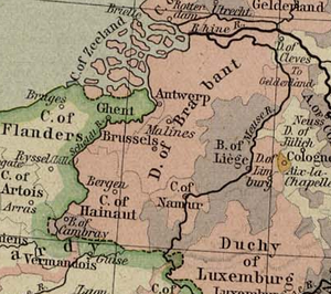 Historical map of the duchy of Brabant and of the Prince-Bishopric of Liège (1477).
In 1430 the Duchies of Lower Lotharingia, Brabant and Limburg were inherited by Philip the Good of Burgundy and became part of the Burgundian Netherlands.
In 1477 the title fell to the House of Habsburg by dowry of Mary of Burgundy. At that time the Duchy of Brabant extended from Luttre, south of Nivelles to 's Hertogenbosch, with Leuven as the capital city. The subsequent history of Brabant is part of the history of the Habsburg Seventeen Provinces.
Eighty Years War and division of Brabant
The Eighty Years' War (1568–1648) brought the northern parts (essentially the present Dutch province of North Brabant) under military control of the northern insurgents. After the Treaty of Westphalia in 1648, the United Provinces' independence was confirmed and northern Brabant was formally ceded to the United Provinces as Staats-Brabant, a federally governed territory.
The southern part remained in Spanish Habsburg hands as a part of the Southern Netherlands. It was transferred to the Austrian branch of the Habsburgs in 1714. During the French occupation of the Southern Netherlands in 1795 the duchy of Brabant was dissolved. The territory was reorganised in the départements of Deux-Nèthes (present province of Antwerp) and Dyle (the later province of Brabant).
Cities of Brabant
 Map of the Duchy of Brabant; territory covering approximately the present Dutch province of North Brabant, the three Belgian provinces Antwerp, Walloon Brabant and Flemish Brabant, and the Brussels-Capital Region.
The Duchy of Brabant was historically divided in four parts each with their own capital. The four capitals are Leuven, Brussels, Antwerp and 's Hertogenbosch. Before 's Hertogenbosch was founded Tienen formed the fourth capital.
The unwalled cities did not have the right to construct walls. Trade was allowed in these areas and usually this right resulted in a larger population and the development of major villages and later cities. The unwalled cities had also the right to hold markets which they held on large market squares. This distinguishes them from surrounding villages who were not allowed to hold markets and did not possess market squares. Being unwalled also meant that some of these places suffered heavily in war and during the Dutch Revolt.
Quarter of Leuven
Walled cities
- Leuven: the capital city of the original region from where Brabant expanded. It has been a university town since 1425.
- Tienen: east of Leuven. Historically, it was, along with Lier, Diest and Tienen, one of the bigger cities after the four regional city capitals.
- Zoutleeuw: east of Tienen. It lies near the boarder of Brabant. In its day, it was a wealthy merchant town. It was also the biggest garrison site near the border with Liege. A swamp separates Zoutleeuw from Liège.
- Landen: south east of Zoutleeuw; a small garrison town. But many known people lived to the near south-west of it: Pepin of Landen, St. Gertrude, St. Bavo, St. Ida and St. Begga.
- Hannut: south of Landen. like Landen, it was a small garrison town.
- Aarschot: north east of Leuven. It was once the capital of the Duchy of Aarschot. It is famous for its fine architecture in the "Demer" gothicstyle, which uses a local type of red stone for its churches and other important buildings.
- Scherpenheuvel: east of Aarschot. It was, and is, the only baroque town in the Netherlands. As such, it is still an important place of pilgrimage.
- Zichem: north of Scherpenheuvel. The city was destroyed during the Dutch Revolt, which left it with a 'rural undeveloped character' ever since. The church and the Maagdentoren (tower of the Virgin) in local red stone are impressive buildings from Zichem's past. Zichem was once part of the Barony of Diest.
- Diest: east of Scherpenheuvel. It was one of Brabant's biggest cities, after the four capitals, and was an important brewery town. The city still counts numerous monuments of its past as attractions today. Like Zichem and Breda it is a Nassau city. Diest was also the capital of the Barony of Diest, and its lands.
- Halen: A small garrison city where the "Battle of the Iron Helmets" took place during World War I: a victory for the Royal Belgian Cavalry.
- Jodoigne: south of Tienen. The city and the surrounding area is known for its white stone, which gives the whole countryside a picturesque character. Many battles have taken place in this region, and other parts of Walloon Brabant.
- Gembloux: south of Jodoigne. Is known for the fine buildings of Gembloux Abbey.
Unwalled cities
- Wavre: west of Jodoigne and today the capital of Walloon Brabant
- Dormaal: south of Zoutleeuw. Although it holds city rights it never really developed into a city and could be considered a village.
Quarter of Brussels
Walled cities
- Brussels: the capital city of this part of Brabant. Also former capital of the Seventeen Provinces, and of the Southern part of the Seventeen Provinces; today it is the capital of the Kingdom of Belgium. Once known as the 'city of nobles' because of the presence of the Royal Court.
- Vilvoorde: north of Brussels. The first prison of Belgium was built here when the region was under Austrian rule.
- Nivelles: south of Brussels. Known for its beautiful church and as the birthplace of Saint Gertrude of Nivelles; who played an important role in the early history of Brussels and the local region.
Unwalled cities
- Braine-l'Alleud: south of Brussels. The famous Battle of Waterloo, where the Duke of Wellington of Great Britain defeated Emperor Napoleon I of France, took place near this small city. The church functioned as a hospital at the time for the many casualties of the conflict.
- Genappe: east of Nivelles; a small city with a charming old town centre developed around a market square.
- La Hulpe: north east of Braine Alleud. Could be considered a village, although it was allowed to hold markets and held justice in its own small domain. It has become more wellknown lately as the residence of Solvay.
- Overijse: south west of Brussels. Historically more important, as it held its own trade market Béguinage and cloth hall; but the city never expanded beyond the large market square.
- Tervuren: east of Brussels. Tervuren was the country residence of the Dukes of Brabant, and continued as such when the Habsbourgs took over. Stately homes of the old noble families characterise Tervuren. Also, the more recent Congo Museum is situated in the Park of Tervuren.
- Duisburg: south east of Tervuren; was ruled by the Abbey of Coudenberg. who never allowed it to develop into a city.
- Merchtem: north west of Brussels. A rather small unwalled city, with pretentions, but it was larger than the towns of La Hulpe or Duisburg.
- Asse: West of Brussels. Next to Genappe and Braine Alleud, it was one of the bigger unwalled cities of the Brussels quarter. Today it has an old hospital and market square.
Quarter of Antwerp
Walled cities
- Antwerp: the capital of this quarter. Also the Episcopal see for this part of Brabant, which included the Barony of Breda and the Margravite of Bergen op Zoom. Antwerp today is a city of business and trade with many fine merchant palaces still standing in the old town.
- Lier: south east of Antwerp. Known as the wedding site of the parents of Charles V, Holy Roman Emperor, an event which led to many future political changes.
- Herentals: east of Lier. A city located in a forested area.
- Zandvliet: north of Antwerp. A garrison city built to defend the Southern Netherlands.
- Bergen op Zoom: north of Zandvliet. Old fortified port town.
- Steenbergen: north of Bergen op Zoom; also an important port town.
- Breda: north east of Antwerp. One of the Nassau trade cities.
Unwalled cities
- Turnhout: north of Herentals. The largest of the unwalled cities of Brabant.
- Geel: east of Herentals. Known for its early and present health care facilities.
- Hoogstraten: north east of Antwerp. Capital of the county of Hoogstraten.
- Duffel: south of Antwerp. More illustrious in the past then it is today. An important barony of the later Middle Ages which was largely destroyed by wars. Its name has been remembered, and is now used as the common military name for a small clothes carrying bag.
- Walem: part of the barony of Duffel; never became more than a village.
- Arendonk: east of Turnhout. Famous for training falcons and eagles for use in the Hunt.
Note: the city of Mechelen formed an independent state along with the Land of Heist-op-den-Berg and Gestel. Willemstad, Geertruidenberg and Klundert were part of the County of Holland; whose name in turn was later used to describe or label large areas of the Netherlands.
Quarter of Bois-le-Duc
Walled cities
- Bois-le-Duc ('s Hertogenbosch): regional capital city and Episcopal see of this part of Brabant.
- Heusden: north west of 's Hertogenbosch. It was said to be an "untakeable city" (in the military battle meaning term), and it lies close to the boundaries of the old Counties of Holland and Guelders.
- Helmond: built as a military counterweight barrier to the counts of Guelders. It has a massive water fortress of historical interest.
- Ravenstein: east of 's Hertogenbosch. Became part of the Duchy of Cleves in 1396, along with Meghem (Megen) and Grave. A later Duke of Clives sent his sister, Anne of Cleves, to England to become one of the two surviving wives of King Henry VIII.
- Meghem (now called Megen): north-west of Ravenstein.
- Grave: south of Ravenstein: These three smaller garrison towns of the north-east side of Brabant, later became part of the Duchy of Cleves, as the Barony of Ravenstein.
- Eindhoven: was granted city rights in 1232 shortly after starting out as one of the very first 'planned' new cities in Europe. Its magnificent walls were demolished in the Eighty Years War, and were never to be rebuilt.
Unwalled cities
See also
- Dukes of Brabant
- Dukes of Brabant family tree
- War of Devolution (1667–1668)
 Burgundian Circle (1512–1806) of the Holy Roman EmpireRemained
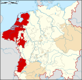
County Imperial City Besançon3Dependent territories Categories:- Former principalities
- Former polities in the Netherlands
- States of the Holy Roman Empire
- States and territories established in 1183
- States and territories disestablished in 1648
- Brabant
- Dukes of Brabant
- Duchy of Brabant
- Seventeen Provinces
- Burgundian Circle
- States and territories established in the 1180s


Wikimedia Foundation. 2010.