- North Carolina Highway 2
-
"NC 2" redirects here. For the airplane NC-2, see Curtiss NC."NC 2" redirects here. NC 2 may also refer to North Carolina's 2nd congressional district.
NC 2

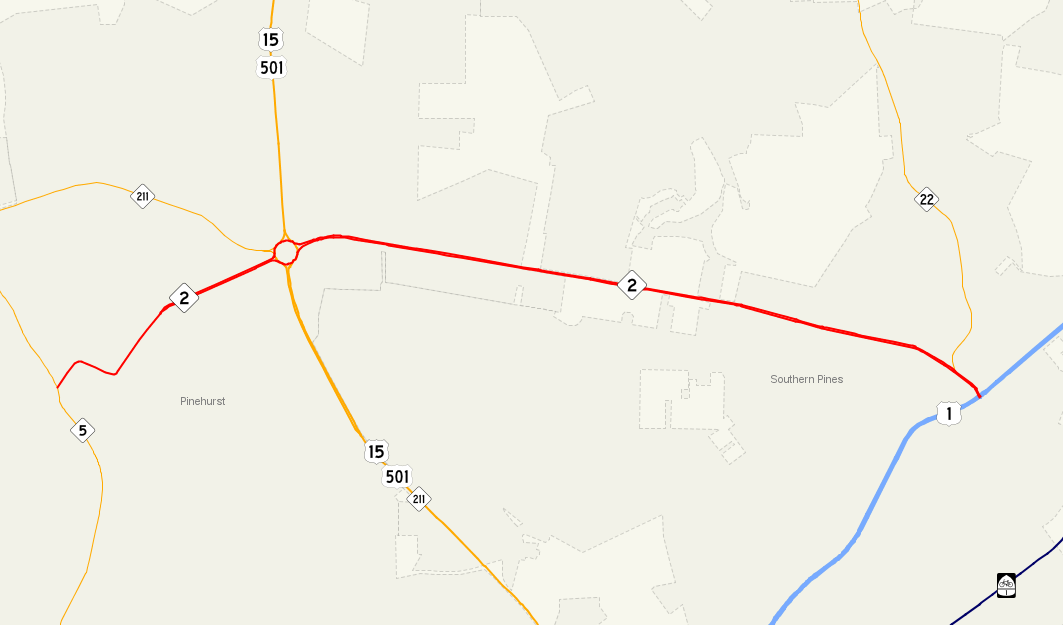
Route information Maintained by NCDOT Length: 5.49 mi[2] (8.84 km) Existed: 1939[1] – present Major junctions West end:  NC 5 in Pinehurst

 US 15 / US 501 / NC 211 in Pinehurst
 NC 22 in Southern Pines
East end:  US 1 in Southern Pines
Location Counties: Moore Highway system ← US 1NC 3  →
→NC 2 is a five-mile (8 km) North Carolina state highway that runs entirely in Moore County. Its primary function is to connect the two Sandhills towns of Southern Pines and Pinehurst.
Contents
Route description
NC 2's western terminus is at a tree-lined intersection with NC 5, just south of downtown Pinehurst. Traveling in a northeasterly direction (signed east), NC 2 arrives at the Pinehurst Traffic Circle where US 15-501 and NC 211 meet. Exiting the traffic circle on an easterly spur, NC 2 continues east into the city of Southern Pines. After entering the city limits, NC 2 intersects with the southern terminus of NC 22 before arriving at its own terminus at the U.S. 1 freeway. The majority of NC 2 is locally known as Midland Road. In Pinehurst, Midland Road turns into Palmetto Street, Azalea Road and Cherokee Street where it ends at Beulah Hill Road (NC 5).
History
- 1934 - As North Carolina renumbered most its highways, NC 2 was randomly selected to be the road that ran from Candor to Southern Pines. At this time, the community that is now part of northern Southern Pines was known as Manly.
- 1939 - The section of NC 2 west of NC 5 (Beulah Hill Road) was renumbered to NC 211, drastically shortening the length of the route. The remaining NC 2 was upgraded to a paved, four-lane highway, being one of the first in the state.[1]
Major intersections
The entire route is in Moore County.
Location Mile Destinations Notes Pinehurst 0.00 NC 5Western terminus of NC 2 1.57 US 15 / US 501 / NC 211Pinehurst Traffic Circle Southern Pines 5.28 NC 225.49 US 1Eastern Terminus of NC 2 1.000 mi = 1.609 km; 1.000 km = 0.621 mi References
External links
Categories:- State highways in North Carolina
- Transportation in Moore County, North Carolina

Wikimedia Foundation. 2010.