- Kamerik-Mijzijde
-
Mijzijde — Hamlet — Kamerik-Mijzijde 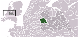 Kamerik-Mijzijde in the municipality of Woerden.
Coordinates: 52°08′35″N 4°53′09″E / 52.14306°N 4.88583°ECoordinates: 52°08′35″N 4°53′09″E / 52.14306°N 4.88583°E Country Netherlands Province Utrecht Municipality Woerden Population (2006) – Total 160 Time zone CET (UTC+1) – Summer (DST) CEST (UTC+2) Postal code Kamerik-Mijzijde, also just called Mijzijde, is a hamlet in the Dutch province of Utrecht. It is a part of the municipality of Woerden, and lies about 4 km north of the city of Woerden.
Kamerik-Mijzijde has a population of around 160.[1] It consists of a number of farms some distance west from the villages of Kamerik and Kanis.
Between 1818 and 1857, Kamerik-Mijzijde was the name of a separate municipality, covering the western half of the later municipality of Kamerik.[2]
References
- ^ Statistics Netherlands (CBS), Statline: Kerncijfers wijken en buurten 2003-2005 [1]. As of 1 January 2005.
- ^ Ad van der Meer and Onno Boonstra, "Repertorium van Nederlandse gemeenten", KNAW, 2006. [2]
Cities/towns Villages Hamlets Barwoutswaarder - Bekenes - Breeveld - Breudijk - De Bree - Geestdorp - Gerverscop - Harmelerwaard - Houtdijken - Kamerik-Mijzijde - Kanis - Kromwijk - Lagebroek - Meije (in part) - Oud-Kamerik - Reijerscop - Rietveld - TeckopCategories:- Populated places in Utrecht (province)
- Former municipalities of Utrecht (province)
- Utrecht geography stubs
Wikimedia Foundation. 2010.