- Loch Eil Outward Bound railway station
-
Loch Eil Outward Bound 
Loch Iall 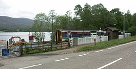
Location Place Loch Eil Local authority Highland Coordinates 56°51′18″N 5°11′31″W / 56.855°N 5.192°WCoordinates: 56°51′18″N 5°11′31″W / 56.855°N 5.192°W Operations Station code LHE Managed by First ScotRail Number of platforms 1 Live arrivals/departures and station information
from National Rail EnquiriesAnnual rail passenger usage 2002/03 * 611 2004/05 *  507
5072005/06 * 4752006/07 *  637
6372007/08 * 9132008/09 * 8602009/10 * 548History May 1985 Station opened National Rail - UK railway stations A B C D E F G H I J K L M N O P Q R S T U V W X Y Z * Annual passenger usage based on sales of tickets in stated financial year(s) which end or originate at Loch Eil Outward Bound from Office of Rail Regulation statistics. Please note: methodology may vary year on year. Loch Eil Outward Bound railway station is a railway station on the northern bank of Loch Eil in the Highland region of Scotland. This station is on the West Highland Line. Its name refers to the nearby Outward Bound centre that the station was built to serve.
History
This station opened in May 1985. It comprises a single platform on the north side of the railway.
Signalling
On 6 December 1987, the station became a Token Exchange Point when the Radio Electronic Token Block (RETB) system was commissioned between Mallaig Junction (now called 'Fort William Junction') and Mallaig. The RETB is controlled from a Signalling Centre at Banavie railway station.
The Train Protection & Warning System was installed in 2003.
Preceding station  National Rail
Following station Corpach First ScotRail
West Highland LineLocheilside Categories:- Railway stations in Highland (council area)
- Railway stations opened by British Rail
- Railway stations opened in 1985
- Railway stations served by First ScotRail
- Scotland railway station stubs

Wikimedia Foundation. 2010.