- Maryland Route 272
-
Maryland Route 272

Route information Maintained by MDSHA Length: 20.67 mi[1] (33.27 km) Major junctions South end: Elk Neck State Park  MD 7 in North East
 US 40 in North East
 I-95 in Bay View
 MD 274 in Bay View
 MD 273 in Calvert
North end:  PA 272 near Calvert
Location Counties: Cecil Highway system Maryland highway system
Interstate • US • State • Minor • Former • Turnpikes←  MD 270
MD 273 →Maryland Route 272 (MD 272) is a state highway in the U.S. state of Maryland. The state highway runs 20.67 miles (33.27 km) from Turkey Point within Elk Neck State Park north through North East to the Pennsylvania state line near Calvert, where the highway continues as Pennsylvania Route 272 (PA 272). MD 272 is the main north–south highway of central Cecil County, connecting the Elk Neck between the North East River and Elk River with U.S. Route 40 (US 40) in North East, Interstate 95 (I-95) in Bay View, MD 273 in Calvert, and Rising Sun via MD 274. The state highway contains a section of MD 274 Truck between MD 274 in Bay View and MD 273 in Calvert.
The section of MD 272 between North East and Bay View was paved by 1910. The remainder of the state highway north to Calvert and south to Old Elk Neck Road was completed in several sections in the 1930s. The first relocations of MD 272 occurred when both railroads near North East were bridged in the early 1940s and early 1950s. Multiple relocations occurred in the late 1950s and early 1960s along the whole length of the highway to eliminate curves and tie the state highway into I-95. MD 272 reached its current extent when it was extended south into Elk Neck State Park around 1980.
Contents
Route description
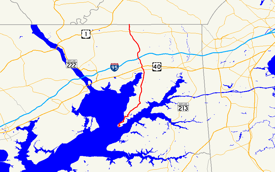
MD 272 begins at a parking lot at the trail head for the Turkey Point Light within Elk Neck State Park. The state highway heads north as two-lane Turkey Point Road through a residential area before returning to the state park property. MD 272 passes through several curves and passes by access roads to the Elk River and Northeast River areas of the state park. The state highway emerges from the state park just before an intersection with Elk River Lane, which access Old Elk Neck Road that leads northeast toward Elkton. MD 272 curves north toward North East, passing through forest with scattered residences. The state highway passes by old alignments in the form of Arrants Road, Old Log Cabin Road, and Hance Point Road.[1][2]
MD 272 splits into a one-way pair featuring Mauldin Avenue northbound and Main Street southbound immediately before entering the town of North East. Main Street, which is one lane with parking on both sides, passes by St. Mary Anne's Episcopal Church. Mauldin Avenue has two lanes. Both directions intersect MD 7 (Cecil Street) and cross North East Creek before the one-way pair comes together, with Main Street heading north to a dead end before MD 272, now named Mauldin Avenue, curves northwest to cross the Amtrak Northeast Corridor and leave the town limits. The state highway passes through a commercial area around its intersection with US 40 (Pulaski Highway), where the highway's name changes to North East Road. MD 272 curves north to collect the old alignment, Rogers Road. The old alignment splits to the northwest as Nazarene Camp Road as the present alignment crosses over CSX's Philadelphia Subdivision. The old alignment parallels the current highway as Maryville Road, which hits a dead end just south of MD 272's partial cloverleaf interchange with I-95 (John F. Kennedy Memorial Highway), within which MD 272 is a four-lane divided highway.[1][2]
North of I-95, MD 272's old alignment appears as Old Bayview Road in the village of Bay View, where the state highway reduces to an undivided two-lane road and intersects MD 274 (Joseph Biggs Memorial Highway) and the entrance to Cecil College. After collecting the northern end of Old Bayview Road, MD 272 crosses North East Creek parallel with the Gilpin's Falls Covered Bridge. The state highway heads north through farmland and the village of Zion, where Old Zion Road forms the old alignment. MD 272 continues north to Calvert, where the highway intersects Brick Meetinghouse Road, the old alignment of MD 273 that leads to the East Nottingham Friends Meetinghouse, as well as current MD 273 (Telegraph Road). MD 272's old alignment through Calvert, Quaker Lane on the south and Walnut Garden Road on the north, passes by the Elisha Kirk House and Calvert Manor. MD 272 continues north as Chrome Road to the Pennsylvania state line, where Chrome Road continues north as PA 272 toward Chrome and Nottingham.[1][2]
History
The first portion of MD 272 to be built from Cecil Avenue in North East north to Old Farmington Road in Bay View, which was paved by 1910.[3] That road was resurfaced in 1926 and 1927; in addition, the road was extended south to the southern end of Main Street in North East.[4][5] A second section of MD 272 was paved from Zion to Calvert around 1930.[6] The northern section of pavement was extended north from Calvert to the Pennsylvania state line in 1932.[7][8]. The southern portion of MD 272 was extended south from North East to what is now Hance Point Road by 1933 and to Old Log Cabin Road by 1935.[7][8][9] The gap between Bay View and Calvert was filled, including a new bridge parallel to the Gilpin's Falls Covered Bridge over North East Creek, around 1936.[10] MD 272 was completed from Elk Neck to the Pennsylvania state line when the final section of highway south to Old Elk Neck Road was surfaced in 1939.[11][12]
The first realignment of MD 272 occurred in 1940 when a bridge was constructed over the Baltimore and Ohio Railroad (now CSX) north of North East.[12] The Main Street bridge over North East Creek in North East was replaced in 1945 as an accelerated non-military wartime project approved by the War Production Board, replacing a 1903 truss bridge.[13][14] The next realignment occurred with a bridge over the Pennsylvania Railroad (now Amtrak) in North East in 1954, resulting in the present intersection with US 40.[15][16]
By 1956, much of MD 272 was under construction to be relocated, widened, and resurfaced. Construction south of North East began in 1956, resulting in bypasses of what are now Hance Point Road, Old Log Cabin Road, and Arratts Road.[17][18] MD 272 was widened from US 40 to Calvert starting in 1957, including relocations at Calvert, Zion, and Bay View.[17] MD 272 was relocated from the Pennsylvania Railroad crossing to Bay View when the original diamond interchange with I-95 was constructed in 1963.[19] Around 1968, Mauldin Avenue was extended in both directions in North East to serve as the northbound component of a one-way pair.[20][21] MD 272 was extended south to its present terminus at Turkey Point around 1981.[22] The state highway was expanded to a four-lane divided highway within the I-95 interchange in conjunction with the reconstruction of the northern half of the interchange with loop ramps in 2001.[23]
Junction list
The entire route is in Cecil County.
Location Mile[1] Destinations Notes Elk Neck State Park 0.00 Entrance to Turkey Point parking lot – Turkey Point Light Southern terminus North East 11.60 MD 7 (Cecil Avenue) – Charlestown, ElktonMD 272 intersects MD 7 as a one-way pair: Mauldin Street northbound and Main Street southbound 12.22 US 40 (Pulaski Highway) – Elkton, PerryvilleBay View 14.00 I-95 (John F. Kennedy Memorial Highway) – Baltimore, New YorkI-95 Exit 100; partial cloverleaf interchange 14.60 MD 274 west (Joseph Biggs Memorial Highway) – Rising SunEastern terminus of MD 274, south end of MD 274 Truck overlap Calvert 19.35 


MD 273 / MD 274 Truck west (Telegraph Road) – Rising Sun, Newark, DENorth end of MD 274 Truck overlap 20.67 PA 272 north (Chrome Road) – Nottingham, PANorthern terminus; Pennsylvania state line 1.000 mi = 1.609 km; 1.000 km = 0.621 mi References
- ^ a b c d e "Highway Location Reference: Cecil County" (PDF). Maryland State Highway Administration. 2009. http://www.marylandroads.com/Location/2009_CECIL.pdf. Retrieved 2010-10-16.
- ^ a b c Google, Inc. Google Maps – Maryland Route 272 (Map). Cartography by Google, Inc. http://maps.google.com/maps?f=d&source=s_d&saddr=Turkey+Point+Rd&daddr=MD-272+N%2FChrome+Rd&hl=en&geocode=FUweWgIdVkJ4-w%3BFbwaXgIdOJ94-w&mra=ls&sll=39.590345,-75.934753&sspn=0.242876,0.617294&ie=UTF8&t=h&z=10. Retrieved 2010-10-16.
- ^ Maryland Geological Survey. Map of Maryland (Map) (1910 ed.).
- ^ Report of the State Roads Commission of Maryland. 1924-1926. Baltimore: Maryland State Roads Commission. January 1927. pp. 30, 75. http://www.archive.org/details/annualreportsofs1924mary. Retrieved 2010-10-16.
- ^ Maryland Geological Survey. Map of Maryland: Showing State Road System and State Aid Roads (Map) (1927 ed.).
- ^ Maryland Geological Survey. Map of Maryland Showing State Road System: State Aid Roads and Improved County Road Connections (Map) (1930 ed.).
- ^ a b Maryland Geological Survey. Map of Maryland Showing State Road System: State Aid Roads and Improved County Road Connections (Map) (1933 ed.).
- ^ a b Report of the State Roads Commission of Maryland. 1931-1934. Baltimore: Maryland State Roads Commission. 1934-12-28. pp. 328–329. http://www.archive.org/details/reportofstateroa1931mary. Retrieved 2010-10-16.
- ^ Maryland Geological Survey. Map of Maryland Showing State Road System: State Aid Roads and Improved County Road Connections (Map) (1935 ed.).
- ^ Report of the State Roads Commission of Maryland. 1935-1936. Baltimore: Maryland State Roads Commission. 1936-12-04. p. 82. http://www.archive.org/details/reportofstateroa1935mary. Retrieved 2010-10-16.
- ^ Maryland State Roads Commission. General Highway Map: State of Maryland (Map) (1939 ed.).
- ^ a b Report of the State Roads Commission of Maryland. 1939-1940. Baltimore: Maryland State Roads Commission. 1941-03-15. p. 104. http://www.archive.org/details/reportofstateroa1939mary. Retrieved 2010-10-16.
- ^ Report of the State Roads Commission of Maryland. 1943-1944. Baltimore: Maryland State Roads Commission. 1945-03-01. pp. 4, 77. http://www.archive.org/details/reportofstateroa1943mary. Retrieved 2010-10-16.
- ^ Report of the State Roads Commission of Maryland. 1945-1946. Baltimore: Maryland State Roads Commission. 1947-02-01. pp. 60, 86. http://www.archive.org/details/reportofstateroa1945mary. Retrieved 2010-10-16.
- ^ "NBI Structure Number: 100000070036010". National Bridge Inventory. http://nationalbridges.com/nbi_record.php?StateCode=24&struct=100000070036010. Retrieved 2010-10-16.
- ^ Report of the State Roads Commission of Maryland. 1955-1956. Baltimore: Maryland State Roads Commission. 1956-11-02. p. 137. http://www.archive.org/details/reportofstateroa1955mary. Retrieved 2010-10-16.
- ^ a b Report of the State Roads Commission of Maryland. 1957-1958. Baltimore: Maryland State Roads Commission. 1958-12-15. p. 43. http://www.archive.org/details/reportofstateroa1957mary. Retrieved 2010-10-16.
- ^ Maryland State Roads Commission. Maryland: Official Highway Map (Map) (1960 ed.).
- ^ Maryland State Roads Commission. Maryland: Official Highway Map (Map) (1963 ed.).
- ^ "NBI Structure Number: 100000070063010". National Bridge Inventory. http://nationalbridges.com/nbi_record.php?StateCode=24&struct=100000070063010. Retrieved 2010-10-16.
- ^ "NBI Structure Number: 100000070062020". National Bridge Inventory. http://nationalbridges.com/nbi_record.php?StateCode=24&struct=100000070062020. Retrieved 2010-10-16.
- ^ Maryland State Highway Administration. Maryland: Official Highway Map (Map) (1981-82 ed.).
- ^ "Highway Location Reference: Cecil County" (PDF). Maryland State Highway Administration. 2001. http://www.marylandroads.com/Location/2001_CECIL.pdf. Retrieved 2010-10-16.
External links
- MD 272 @ MDRoads.com
- MD 274 Truck signed along MD 272
Roads in Cecil County, Maryland State highways 
U.S. Highways Interstate Highways Categories:- State highways in Maryland
- Roads in Cecil County, Maryland


Wikimedia Foundation. 2010.