- Dirk Hartog Island
-
Dirk Hartog 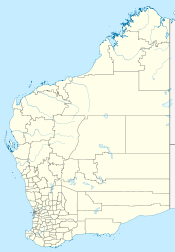
 Dirk Hartog Island (Western Australia)
Geography Location Indian Ocean Coordinates 25°50′S 113°05′E / 25.833°S 113.083°ECoordinates: 25°50′S 113°05′E / 25.833°S 113.083°E Area 620 km2 (239 sq mi) Length 80 km (50 mi) Width 15 km (9.3 mi) Country AustraliaTerritory  Western Australia
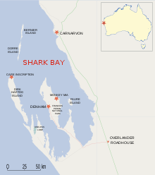 map of Shark Bay region

 Cape Inscription lighthouse, c.1910
Dirk Hartog Island is an island off the Gascoyne coast of Western Australia, within the Shark Bay World Heritage Area. It is about 80 kilometres long and between 3 and 15 kilometres wide and is Western Australia's largest and most western island. It covers an area of 620 square kilometres and is approximately 850 km north of Perth. It was originally named Eendrachtsland after the ship Eendracht, which visited it under the command of Dirk Hartog in 1616.
Contents
History
See also: Hartog PlateThe island was discovered on 25 October 1616 by Dutch sea captain Dirk Hartog, who was blown off course while sailing in the VOC ship Eendracht from Cape Town to Batavia (Jakarta).[1] Hartog inscribed his name and the date on a pewter plate and nailed it to a tree.
In 1697 the Dutch captain Willem de Vlamingh landed on the island and discovered Hartog's plate. He replaced it with one of his own, which included a copy of Hartog's inscription, and took the original plate home to Amsterdam, where it is still kept in the Rijksmuseum Amsterdam.
In 1801 the island was visited by a French expedition aboard the Naturaliste led by Captain Emmanuel Hamelin. This expedition found de Vlamingh's plate almost buried in the sand, its post having rotted away. The Captain ordered that it be re-erected in its original position. In 1818 the Uranie with French explorer Louis de Freycinet, who had been an officer in Hamelin's 1801 crew, sent a boat ashore to recover de Vlamingh's plate. It eventually arrived in Paris, only to be lost for over a century. It was found in 1940 and returned to Australia in 1947, where it can now be seen in the Western Australian Maritime Museum in Fremantle, Western Australia.
In 1869, Francis Louis von Bibra (son of Franz Ludwig von Bibra) was granted a lease on the island. Von Bibra established sheep on the island and traded guano from its bays.[2]
In January 1998, two French coins were found by a team led by Philippe Godard and Max Cramer in Turtle Bay. On 1 April 1998, an intact bottle bearing a lead closure similar to that recovered earlier in the year was discovered by expedition team members Bob Sheppard, Bob Creasy and Dr Michael McCarthy. These coins and bottle are thought to have been left by the French captain Louis Aleno de St Aloüarn who landed ashore in 1772 and annexed Western Australia in the name of the French King. As proof the captain buried a parchment in a bottle and two French coins.[3]
Perth Lord Mayor Sir Thomas Wardle purchased the island as a private retreat for his family in about 1969 and later retired there, becoming a semi-recluse with his wife. With the exception of the pastoral homestead, the island later returned to government ownership and became part of the Shark Bay Marine Park.[4] It is now run as an eco-tourism resort and maintained by Wardle's grandson, Kieran Wardle.
On 16 March 2008, Australian Prime Minister Kevin Rudd announced that the wreck of the World War II German raider Kormoran had been found on the seabed about 150 kilometres west of the island.[5]
Description
The northerly most point Cape Inscription is the location of the plates and the main lighthouse. The bay facing north next to Cape Inscription 25°28′S 112°58′E / 25.467°S 112.967°E is known as Turtle Bay.
The most south westerly point — Surf Point 26°07′26″S 113°10′46″E / 26.12389°S 113.17944°E — is located at the channel known as South Passage 26°07′55″S 113°09′31″E / 26.13194°S 113.15861°E across from Steep Point on its south west side.
Environment
The island consists mostly of scrub-covered sand dunes. At times it has been used as a sheep station and supported 20,000 head of sheep; however, the numbers have been reduced in recent years for environmental reasons. It is bounded by the Shark Bay Marine Park, part of Shark Bay World Heritage Site. Part of the island is leased to the Wardle family who run it as an ecotourism destination. The region is widely used for recreational fishing.
Dirk Hartog is an important nesting site for Loggerhead Sea Turtles, with Green Turtles and Loggerhead Turtles both nesting on the beaches. It is also home for the endemic nominate subspecies of the White-winged Fairy-wren. Quoin Bluff, mid-way along the eastern side of the island, holds an important Pied Cormorant nesting colony which, along with Freycinet Island some 80 km to the south-east, forms the Quoin Bluff and Freycinet Island Important Bird Area, identified as such by BirdLife International.[6]
See also
- Caert van't Landt van d'Eendracht, an early Dutch map of the region
References
- ^ "Dirk Hartog Landing Site 1616 - Cape Inscription Area more information". National heritage places. Department of the Environment, Water, Heritage and the Arts. 27 June 2008. http://environment.gov.au/heritage/places/national/cape-inscription/information.html. Retrieved 25 October 2008.
- ^ Nyman, Lois; von Bibra, Graeme (1996). The von Bibra story. Launceston, Tasmania: Foot & Playsted. pp. 64–66. ISBN 9780959718812. OCLC 38406671.
- ^ Walter R. Bloom,”The Role of a French Écu in the Colonization of Western Australia”, and ”Another French Écu surfaces in Western Australia”, The Numismatic Association of Australia Journal, vol.9, 1998, pp.34 – 42; vol.11, 2000, pp.47 - 49. http://www.museum.wa.gov.au/collections/maritime/march/DHI-site/stal-02.html
- ^ "Cape Inscription - Culture and History". The Age. http://www.theage.com.au/travel/travel-factsheet/cape-inscription--culture-and-history-20081117-68j1.html. Retrieved 10 April 2009.
- ^ Australian Associated Press (16 March 2008). "HMAS Sydney hunt digs up the Kormoran". The West Australian. Archived from the original on 22 March 2008. http://web.archive.org/web/20080322170438/http://www.thewest.com.au/default.aspx?MenuID=145&ContentID=63113. Retrieved 16 March 2008.
- ^ BirdLife International. (2011). Important Bird Areas factsheet: Quoin Bluff and Freycinet Island (Shark Bay). Downloaded from http://www.birdlife.org on 25/09/2011.
External links
- Dirk Hartog Island website
- Map of the island
- Rijksmuseum Amsterdam detail of plate
- [1] Western Australian Museum plate site
Further reading
- Playford, Phillip E (1998). "A story of two plates". Voyage of discovery to Terra Australis : by Willem De Vlamingh in 1696–97. Perth, W.A.: Western Australian Museum. pp. 51–60. ISBN 0730712214. OCLC 39442497.
- Green, J., (ed.) Report on the 2006 Western Australian Museum, Department of Maritime Archaeology, Cape Inscription National Heritage Listing Archaeological Survey. Report—Department of Maritime Archaeology Western Australian Museum, No. 223 Special Publication No. 10, Australian National Centre of Excellence for Maritime Archaeology
Categories:- Islands of Western Australia
- Shark Bay


Wikimedia Foundation. 2010.