- Geography of Trinidad and Tobago
-
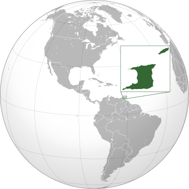
 Map of Trinidad and Tobago
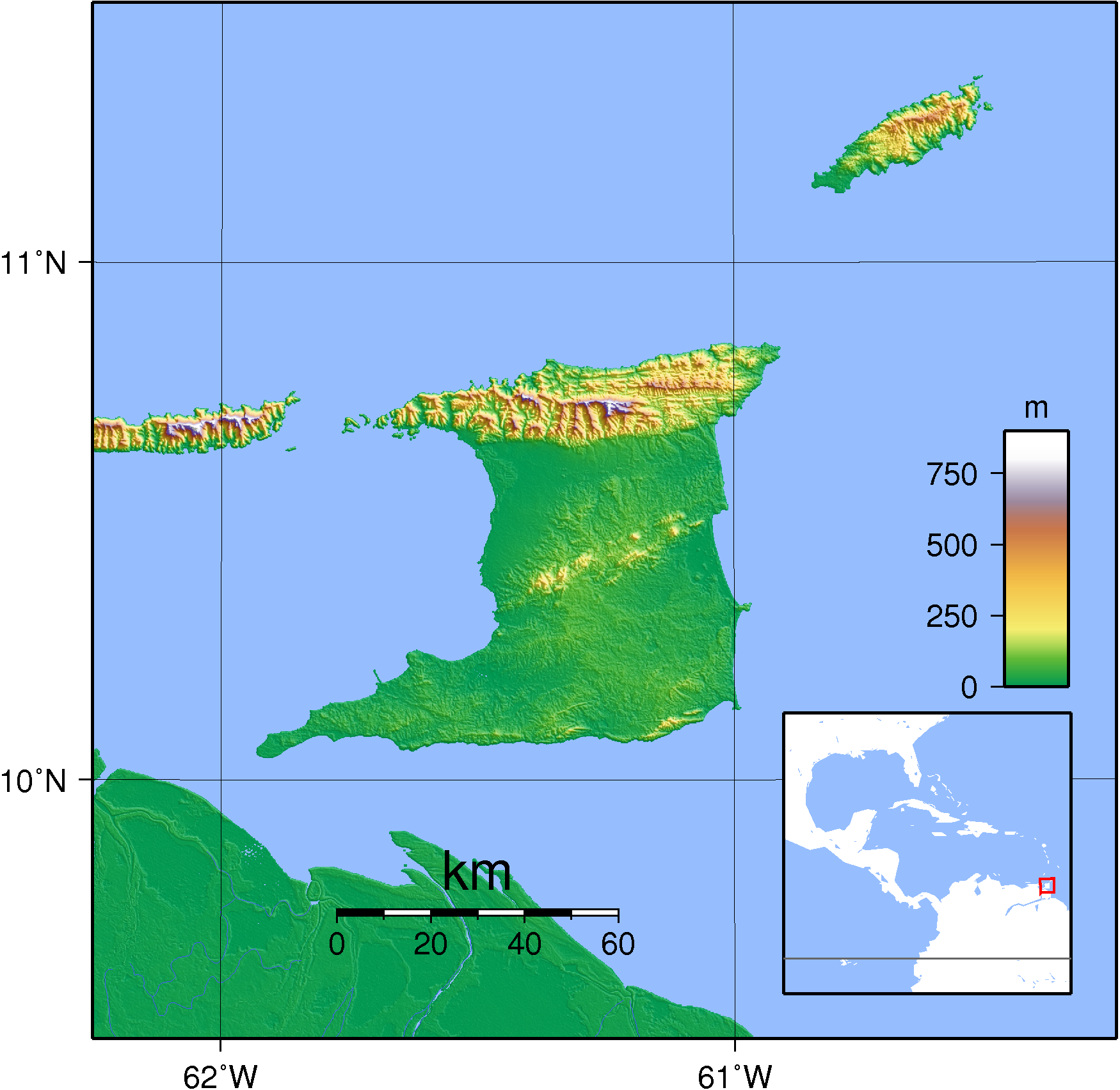
 Topography of Trindad and Tobago
Trinidad and Tobago is an archipelagic republic in the southern Caribbean between the Caribbean Sea and the North Atlantic Ocean, northeast of Venezuela. They are southeasterly islands of the Lesser Antille, Monos, Huevos, Gaspar Grande (or Gasparee), Little Tobago, and St. Giles Island. Trinidad is 11 km (6.8 mi) off the northeast coast of Venezuela and 130 km (81 mi) south of the Grenadines. The island measures 4,768 km2 (1,841 sq mi) in area (comprising 93.0% of the country's total area) with an average length of 80 km (50 mi) and an average width of 59 km (37 mi). The island appears rectangular in shape with three projecting peninsular corners. Tobago is 30 km (19 mi) northeast of Trinidad and measures about 298 km2 (115 sq mi) in area, or 5.8% of the country's area, 41 km (25.5 mi) in length and 12 km (7.5 mi) at its greatest width. The island is cigar-shaped in appearance, with a northeast-southwest alignment.
Geologically, the islands are not part of the Antillean arc. Rather, Trinidad was once part of the South American mainland and is situated on its continental shelf, and Tobago is part of a sunken island arc chain related to the Pacific-derived Caribbean Plate. The islands are separated from the continent of South America by the Gulf of Paria; Dragon's Mouth, a 19-kilometre (11.8 mi)-wide northern passage; and Serpent's Mouth, a 14-kilometre (8.7 mi)-wide southern passage.
Trinidad is traversed by three distinct mountain ranges that are a continuation of the Venezuelan coastal cordillera. The Northern Range, an outlier of the Andes Mountains of Venezuela, consists of rugged hills that parallel the coast. This range rises into two peaks. The highest, El Cerro del Aripo, is 940 metres (3,084 ft) high; the other, El Tucuche, reaches 936 meters. The Central Range extends diagonally across the island and is a low-lying range with swampy areas rising to rolling hills; its maximum elevation is 325 metres (1,066 ft). The Caroni Plain, composed of alluvial sediment, extends southward, separating the Northern Range and Central Range. The Southern Range consists of a broken line of hills with a maximum elevation of 305 metres (1,001 ft).
There are numerous rivers and streams on the island of Trinidad; the most significant are the Ortoire River, 50 kilometres (31.1 mi) long, which extends eastward into the Atlantic, and the 40-kilometre (24.9 mi)-long Caroni River, reaching westward into the Gulf of Paria. Most of the soils of Trinidad are fertile, with the exception of the sandy and unstable terrain found in the southern part of the island.
Tobago is mountainous and dominated by the Main Ridge, which is 29 kilometres (18 mi) long with elevations up to 640 meters. There are deep, fertile valleys running north and south of the Main Ridge. The southwestern tip of the island has a coral platform. Although Tobago is volcanic in origin, there are no active volcanoes. Forestation covers 43 % of the island. There are numerous rivers and streams, but flooding and erosion are less severe than in Trinidad. The coastline is indented with numerous bays, beaches, and narrow coastal plains.
Tobago has several small satellite islands. The largest of these, Little Tobago, is starfish shaped, hilly, and consists of 1.2 km2 (0.46 sq mi) of impenetrable vegetation.
Because it was once part of South America, Trinidad has an assortment of tropical vegetation and wildlife considerably more varied than that of most West Indian islands. Tobago has a generally similar but less varied assortment.
Contents
Statistics
Geographic coordinates: 11°00′N 61°00′W / 11°N 61°W
Map references: Central America and the Caribbean
Area:
total: 5,128 km²
land: 5,128 km²
water: 0 km²Area - comparative: slightly smaller than Delaware
Land boundaries: 0 km
Coastline: 362 km
Maritime claims:
contiguous zone: 24 nmi (44.4 km; 27.6 mi)
continental shelf: 200 nmi (370.4 km; 230.2 mi) or to the outer edge of the continental margin
exclusive economic zone: 200 nmi (370.4 km; 230.2 mi)
territorial sea: 12 nmi (22.2 km; 13.8 mi)Climate: tropical; rainy season (June to December)
Terrain: mostly plains with some hills and low mountains
Elevation extremes:
lowest point: Caribbean Sea 0 m
highest point: El Cerro del Aripo 940 mNatural resources: petroleum, natural gas, asphalt, oil
Land use:
arable land: 15%
permanent crops: 9%
permanent pastures: 2%
forests and woodland: 46% (Based on reported rates of deforestation this figure is actually likely to be closer to 35%)
other: 28% (1993 est.)Irrigated land: 220 km² (1993 est.)
Natural hazards: outside usual path of hurricanes and other tropical storms
Climate
Trinidad and Tobago well within the tropics, both enjoy a generally pleasant maritime tropical climate influenced by the northeast trade winds. In Trinidad the annual mean temperature is 26 °C (78.8 °F), and the average maximum temperature is 34 °C (93.2 °F). The humidity is high, particularly during the rainy season, when it averages 85 to 87%. The island receives an average of 2,110 millimeters (83.1 in) of rainfall per year, usually concentrated in the months of June through December, when brief, intense showers frequently occur. Precipitation is highest in the Northern Range, which may receive as much as 3,810 millimeters (150 in). During the dry season, drought plagues the island's central interior. Tobago's climate is similar to Trinidad's but slightly cooler. Its rainy season extends from June to December; the annual rainfall is 2,500 millimeters (98.4 in). The islands lie outside the hurricane belt; despite this, Hurricane Flora damaged Tobago in 1963, and Tropical Storm Alma hit Trinidad in 1974, causing damage before obtaining full strength.
See also
- Trinidad and Tobago
- Environment of Trinidad and Tobago
- List of reservoirs and dams in Trinidad and Tobago
References
 This article incorporates public domain material from websites or documents of the Library of Congress Country Studies.
- This article incorporates public domain material from websites or documents of the CIA World Factbook.
Sovereign states Antigua and Barbuda · Bahamas · Barbados · Belize · Canada · Costa Rica · Cuba · Dominica · Dominican Republic · El Salvador · Grenada · Guatemala · Haiti · Honduras · Jamaica · Mexico · Nicaragua · Panama · Saint Kitts and Nevis · Saint Lucia · Saint Vincent and the Grenadines · Trinidad and Tobago · United States
Dependencies and
other territoriesAnguilla · Aruba · Bermuda · Bonaire · British Virgin Islands · Cayman Islands · Curaçao · Greenland · Guadeloupe · Martinique · Montserrat · Navassa Island · Puerto Rico · Saint Barthélemy · Saint Martin · Saint Pierre and Miquelon · Saba · Sint Eustatius · Sint Maarten · Turks and Caicos Islands · United States Virgin Islands
Sovereign states Dependencies and
other territories- Aruba
- Bonaire
- Curaçao
- Falkland Islands
- French Guiana
- South Georgia and the South Sandwich Islands
Climate of South America Sovereign states Dependencies and
other territories- Aruba
- Bonaire
- Curaçao
- Falkland Islands
- French Guiana
- South Georgia and the South Sandwich Islands
Categories:

Wikimedia Foundation. 2010.