- Geography of Taiwan
-
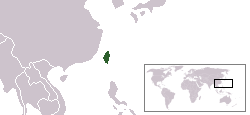
Taiwan Native name: 臺灣 or 台灣 
Map of Taiwan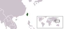
Geography Location East Asia Coordinates 23°46′N 121°0′E / 23.767°N 121°ECoordinates: 23°46′N 121°0′E / 23.767°N 121°E Area 35,801 km2 (13,822.8 sq mi) Length 394 km (244.8 mi) Width 144 km (89.5 mi) Highest elevation 3,952 m (12,966 ft) Highest point Yu Shan Country TaiwanCapital city Taipei Largest city Taipei (pop. 2,630,191) Demographics Population 23,000,000 (as of 2005) Density 642.44 /km2 (1,663.91 /sq mi) Ethnic groups Taiwanese people
98% Han Chinese
70% Hoklo
14% Hakka
14% Mainlander
2% Aboriginal TaiwaneseTaiwan is a medium-sized archipelago in East Asia, located at 23°30" N, 121°00" E and running through the middle of the Tropic of Cancer (23°5" N). It makes up the majority of the territories effectively under the administration of the Republic of China (commonly known as "Taiwan").
Contents
-

Taiwan is mostly mountainous in the east, but gradually transitions to gently sloping plains in the west (satellite photo by NASA).
-

Taiwan posited across Eurasian Plate(in green) and Philippine Plate(in dull red).
Formation
The island of Taiwan was formed approximately 77 to 88 million years ago from a geosyncline (via plate tectonics), and is part of an island arc.[1][2] It was formed when the Eurasian Plate slid under an ancient chain of volcanic islands on the neighboring Philippine Sea Plate. At the northern end of Taiwan, the Philippine Sea Plate slides under the Eurasian Plate.
Physical Boundaries
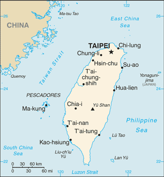
The main island of the archipelago is Taiwan Island, which comprises about 99%[1] of the current jurisdiction of the Republic of China; the other 1% consists of the smaller islands of the archipelago such as Orchid Island and the Penghu islands, along with the tiny islets - Green Island and Hsiao Liuchiu. The archipelago is separated from mainland China by the Taiwan Strait, which ranges from 220 km (137 mi) at its widest point to 130 km (81 mi) at its narrowest point.[2] Taiwan is bounded by the Bashi Channel in the south, the East China Sea in the north, and the Pacific Ocean in the east.[3]
The islands of Kinmen, Matsu, Wuchiu, etc. across the Taiwan Strait, and Pratas and Taiping in the South China Sea, are also administered by the Republic of China. These islands are however not part of the Taiwanese archipelago. Taiwan's area is 35,980 km2 (13,892 sq mi) of which 32,260 km2 (12,456 sq mi) is land and 3,720 km2 (1,436 sq mi) is territorial water claims, making it slightly smaller than the combined area of Maryland and Delaware, or slightly bigger than territory of Belgium. It is 394 km (245 mi) long and 144 km (89 mi) wide. It has a coastline of 1,566.3 km (973.3 mi). The ROC claims an exclusive economic zone of 200 nmi (370.4 km; 230.2 mi) and a territorial sea of 12 nmi (22.2 km; 13.8 mi).[4]
Climate and terrain
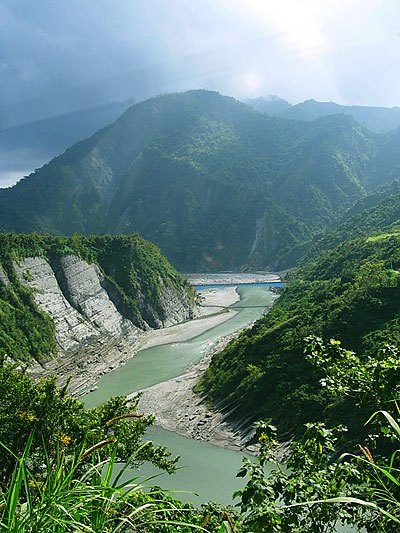
 Shiukuluan River - Hualien County.
The climate on the island is generally marine and varies widely by season in the Northern part and the mountain areas. The South, however, belongs to the tropical belt and is warm and humid all year. From May to June it's rainy season, with almost daily showers. From July to October typhoons are most likely to strike, on average about four direct hits per year. In the northern part of Taiwan, cloudiness is persistent and extensive during the year; in the south, however, the rainy days are always in the summertime, and 90% of the annual precipitation falls during this period. The annual rainfall is usually more than 2,500 mm (98.4 in), close to 5,000 mm (196.9 in) in some Eastern regions.
The terrain in Taiwan is divided into two parts: the flat to gently rolling plains in the west, where 90% of the population lives, and the mostly rugged forest-covered mountains in the eastern two-thirds. The highest elevation in Taiwan is Jade Mountain (Yu Shan), at 3951.798±0.072 m in year 2003.[5]
The western mountain forests are very diverse, with several endemic species such as Formosan Cypress (Chamaecyparis formosensis) and Taiwan Fir (Abies kawakamii), while the Camphor Laurel (Cinnamomum camphora) was once also widespread at lower levels (now mostly cleared for agricultural land). Prior to major Taiwanese economic success, the mountainous areas held several endemic animal species and subspecies, such as the Swinhoe's Pheasant (Lophura swinhoii), Taiwan blue magpie (Urocissa caerulea), Formosan Black Bear (Selanarctos thibetanus formosanus), the Formosan Sika Deer (Cervus nippon taiwanensis or Cervus nippon taiouanus) and the Formosan landlocked salmon (Oncorhynchus masou formosanus). A few of these are now extinct, and many others have been designated endangered species.
Seven national parks in Taiwan showcase the diverse terrain, flora and fauna of the archipelago. Kenting National Park on the southern tip of Taiwan contains uplifted coral reefs, moist tropical forest and marine ecosystems. Yushan National Park has alpine terrain, mountain ecology, forest types that vary with altitude, and remains of ancient road. Yangmingshan National Park has volcanic geology, hot springs, waterfalls, and forest. Taroko National Park has marble canyon, cliff, and fold mountains. Shei-Pa National Park has alpine ecosystems, geological terrain, and valley streams. Kinmen National Park has lakes, wetlands, coastal topography, flora and fauna-shaped island. Dongsha Marine National Park has the Pratas reef atolls for integrity, a unique marine ecology, biodiversity, and is a key habitat for the marine resources of the South China Sea and Taiwan Strait.[6]
See also: List of national parks of the Republic of China, List of mountains in Taiwan, and Endemic species of TaiwanMajor Mountain Ranges
Taiwan's five longitudinal mountain ranges occupy almost half of the island. As a group, they extend 330 km from north to south and average about 80 km from east to west. They include more than two hundred peaks with elevations of over 3,000 m (9,843 ft).
Mountain Range Description Central (中央山脈) The Central Mountain Range extends from Su-ao in the north to Eluanbi in the south, forming a ridge of high mountains and serving as the island's major watershed for rivers and streams. The mountains are predominantly composed of hard rock formations resistant to weathering and erosion, although heavy rainfall has deeply scarred the sides with gorges and sharp valleys. The relative relief of the terrain is usually extensive, and the forest-clad mountains with their extreme ruggedness are almost impenetrable. The east side of the Central Mountain Range is the steepest mountain slope in Taiwan, with fault scarps ranging in height from 120 to 1,200 m (3,937 ft). Hsuehshan (雪山山脈) The Syue Mountain Range lies northwest of the Central Mountain Range, beginning at Sandiaojiao in the northeast and gaining elevation as it extends toward the southwest. Syue Mountain, the main peak, is 3,886 m (12,749 ft) high. Yushan (玉山山脈) The Yushan Mountain Range runs along the southwestern flank of the Central Mountain Range. It includes the island's tallest peak, the 3,952 m (12,966 ft) Jade Mountain. Alishan (阿里山山脈) The Alishan Mountain Range lies west of the Yushan Mountain Range, with major elevations between 1,000 and 2,000 m (6,562 ft). The main peak, Data Mountain (大塔山), towers 2,663 m (8,737 ft). Haian Range (海岸山脈) The East Coast Mountain Range extends from the mouth of the Hualien River in the north to Taitung County in the south, and chiefly consist of sandstone and shale. Although Hsinkangshan (新港山), the highest peak, reaches an elevation of 1,682 m (5,518 ft), most of the range is composed of large hills. Small streams have developed on the flanks, but only one large river cuts across the range. Badlands are located at the western foot of the range, where the ground water level is the lowest and rock formations are the least resistant to weathering. Raised coral reefs along the east coast and the frequent occurrences of earthquakes in the rift valley indicate that the fault block is still rising. Natural resources
Natural resources on the islands include small deposits of gold, copper, coal, natural gas, limestone, marble, and asbestos. The island is 55% forests and woodland (mostly on the mountains) and 24% arable land (mostly on the plains), with 15% going to other purposes. 5% is permanent pastures and 1% is permanent crops.
Natural hazards and environmental issues
Earthquakes and typhoons are the two major natural hazards on the island. On September 21, 1999, an earthquake occurred in the center of Taiwan. The death toll in this catastrophe reached more than 2,000. Meanwhile, mudslides resulting from intensive rain caused by typhoons often leads to disaster.
Current environmental issues include: air pollution; water pollution from industrial emissions and raw sewage; contamination of drinking water supplies; and trade in endangered species. Though regulation of sulfate aerosol emissions from petroleum production is becoming stringent, acid rain remains to be a threat to the health of the residents and the forests. Scholars in Taiwan point out that more than half of its acid rain is actually brought by monsoon rains from mainland China. [3]
-

Bracing on the side of a mountain in Chiayi County prevents landslides caused by typhoons.
-
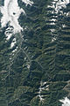
Natural-colour satellite image of landslide scarred mountains in central Taiwan.
See also: Chi-Chi earthquakeMaps of Taiwan
-

On the map of 1896
-

Topographic map
See also
- List of mountains of Taiwan
- List of national parks in Taiwan
- List of rivers of Taiwan
- List of volcanoes in Taiwan
- List of islands of the Republic of China
- Taiwanese hot springs
- List of metropolitan areas in Taiwan
References
- ^ The land area of Taiwan island proper (Formosa) is 35,980 km2,the total area of the ROC jurisdiction is 36,191 km2.
- ^ Government Information Office, Republic of China (Taiwan). "Geography". http://www.gio.gov.tw/ct.asp?xItem=32610&ctNode=2581. Retrieved 2007-05-21.
- ^ National Taiwan Normal University, Geography Department. "Geography of Taiwan: A Summary". http://twgeog.geo.ntnu.edu.tw/english/General/general.htm. Retrieved 2007-05-21.
- ^ "Law on the Exclusive Economic Zone and the Continental Shelf of the Republic of China (中華民國專屬經濟海域及大陸礁層法)". http://law.moj.gov.tw/Eng/Fnews/FnewsContent.asp?msgid=1116&msgType=en. Retrieved 2007-05-21.
- ^ Reported by Taiwan's National Geographic Information System Steering Committee (NGISSC)
- ^ National Parks of Taiwan
External links
- Taiwan Yearbook 2006 -- Geography
- National Parks of Taiwan
- Clip that introduces Taiwan National Parks
Topography of Taiwan Mountain ranges Alishan Range • Central Mountain Range (Chungyang Range) • Haian Range (Coastal Range) • Hsuehshan Range • Yushan RangePlateaus and hill lands Plains Basins Volcano groups * The place names listed above are mainly romanized as Wade-Giles that used in most of academic articles.Taiwan topics History TopicsPolitics Political parties · Government · Elections · Foreign affairs · Political (Legal) · Independence · Constitution · Administrative divisions · One Country on Each Side · Special non-state-to-state relationsSociety Demographics · Education · Ethnic groups · Healthcare · Human rights (LGBT rights) · International rankings · Languages · Religion · Smoking · WomenCulture Aborigines · Cinema · Communications · Cuisine · Holidays · Literature · Media · Music · Night markets · Opera · Photography · Sports · Tea · TelevisionEconomy Banks (Central bank) · Companies · Currency · Energy · Metropolitan areas · Stock exchange · Taiwan Miracle · Tourism · TransportationGeography Cities · Endemic species (protected) · Hot springs · Islands · Mountains · National parks · Rivers · Scenic areas · VolcanoesGeography of Asia Sovereign
states- Afghanistan
- Armenia
- Azerbaijan
- Bahrain
- Bangladesh
- Bhutan
- Brunei
- Burma (Myanmar)
- Cambodia
- People's Republic of China
- Cyprus
- East Timor (Timor-Leste)
- Egypt
- Georgia
- India
- Indonesia
- Iran
- Iraq
- Israel
- Japan
- Jordan
- Kazakhstan
- North Korea
- South Korea
- Kuwait
- Kyrgyzstan
- Laos
- Lebanon
- Malaysia
- Maldives
- Mongolia
- Nepal
- Oman
- Pakistan
- Philippines
- Qatar
- Russia
- Saudi Arabia
- Singapore
- Sri Lanka
- Syria
- Tajikistan
- Thailand
- Turkey
- Turkmenistan
- United Arab Emirates
- Uzbekistan
- Vietnam
- Yemen
States with limited
recognition- Abkhazia
- Nagorno-Karabakh
- Northern Cyprus
- Palestine
- Republic of China (Taiwan)
- South Ossetia
Dependencies and
other territoriesClimate of Asia Sovereign
states- Afghanistan
- Armenia
- Azerbaijan
- Bahrain
- Bangladesh
- Bhutan
- Brunei
- Burma (Myanmar)
- Cambodia
- People's Republic of China
- Cyprus
- East Timor (Timor-Leste)
- Egypt
- Georgia
- India
- Indonesia
- Iran
- Iraq
- Israel
- Japan
- Jordan
- Kazakhstan
- North Korea
- South Korea
- Kuwait
- Kyrgyzstan
- Laos
- Lebanon
- Malaysia
- Maldives
- Mongolia
- Nepal
- Oman
- Pakistan
- Philippines
- Qatar
- Russia
- Saudi Arabia
- Singapore
- Sri Lanka
- Syria
- Tajikistan
- Thailand
- Turkey
- Turkmenistan
- United Arab Emirates
- Uzbekistan
- Vietnam
- Yemen
States with limited
recognition- Abkhazia
- Nagorno-Karabakh
- Northern Cyprus
- Palestine
- Republic of China (Taiwan)
- South Ossetia
Dependencies and
other territories- Christmas Island
- Cocos (Keeling) Islands
- Hong Kong
- Macau
Categories: -


Wikimedia Foundation. 2010.