- National Register of Historic Places listings in DeKalb County, Alabama
-
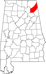 Location of DeKalb County in Alabama
This is a list of the National Register of Historic Places listings in DeKalb County, Alabama.
This is intended to be a complete list of the properties and districts on the National Register of Historic Places in DeKalb County, Alabama, United States. Latitude and longitude coordinates are provided for many National Register properties and districts; these locations may be seen together in a Google map.[1]
There are 12 properties and districts listed on the National Register in the county.
-
- This National Park Service list is complete through NPS recent listings posted November 10, 2011.[2]
Current listings
[3] Landmark name Image Date listed Location City or town Summary 1 Alabama Builders' Hardware Manufacturing Company May 8, 1986 204 8th St., NE.; also 203 8th St., NE.
34°26′46″N 85°42′54″W / 34.445985°N 85.714908°WFort Payne 203 8th represents a boundary increase of October 13, 1992, the Alabama Builder's Hardware Manufacturing Company Complex 2 Alabama Great Southern Railroad Passenger Depot September 10, 1971 NE 5th St.
34°26′39″N 85°43′07″W / 34.444167°N 85.718611°WFort Payne 3 Cherokee Plantation November 29, 1984 100 Cherokee Dr., NE.
34°26′32″N 85°43′46″W / 34.442320°N 85.729330°WFort Payne 4 Collinsville Historic District March 29, 2006 Valley Ave., Main St. and Grand Ave. Collinsville 5 Fort Payne Boom Town Historic District April 21, 1989 Roughly Gault St. from 4th St., NE. to 6th St., NE. Fort Payne 6 Fort Payne Main Street Historic District April 21, 1989 Roughly Gault Ave. from 2nd St., NE. to 2nd St., NW. Fort Payne 7 Fort Payne Opera House April 28, 1970 510 Gault Ave., N.
34°26′49″N 85°43′10″W / 34.446944°N 85.719444°WFort Payne 8 Fort Payne Residential Historic District May 4, 1988 Roughly bounded by Forrest Ave. and Elm St., 5th St. NW., Grand and Alabama Aves., and 4th St., SW. and 2nd St., SW. Fort Payne 9 Dr. J.A. Gorman House February 16, 1996 Lookout St.
34°34′40″N 85°35′37″W / 34.577778°N 85.593611°WMentone 10 Vance C. Larmore House March 23, 2004 810 County Road 606
34°31′49″N 85°39′27″W / 34.530278°N 85.6575°WHammondville 11 Mentone Springs Hotel October 20, 1983 State Route 117
34°34′46″N 85°35′25″W / 34.579444°N 85.590278°WMentone 12 Winston Place March 19, 1987 Off State Route 117
34°34′05″N 85°36′54″W / 34.568008°N 85.614901°WValley Head See also
- List of National Historic Landmarks in Alabama
- National Register of Historic Places listings in Alabama
References
- ^ The latitude and longitude information provided in this table was derived originally from the National Register Information System, which has been found to be fairly accurate for about 99% of listings. For about 1% of NRIS original coordinates, experience has shown that one or both coordinates are typos or otherwise extremely far off; some corrections may have been made. A more subtle problem causes many locations to be off by up to 150 yards, depending on location in the country: most NRIS coordinates were derived from tracing out latitude and longitudes off of USGS topographical quadrant maps created under North American Datum of 1927, which differs from the current, highly accurate GPS system used by Google maps. Chicago is about right, but NRIS longitudes in Washington are higher by about 4.5 seconds, and are lower by about 2.0 seconds in Maine. Latitudes differ by about 1.0 second in Florida. Some locations in this table may have been corrected to current GPS standards.
- ^ "National Register of Historic Places: Weekly List Actions". National Park Service, United States Department of the Interior. Retrieved on November 10, 2011.
- ^ Numbers represent an ordering by significant words. Various colorings, defined here, differentiate National Historic Landmark sites and National Register of Historic Places Districts from other NRHP buildings, structures, sites or objects.
U.S. National Register of Historic Places in Alabama Lists by county Autauga • Baldwin • Barbour • Bibb • Blount • Bullock • Butler • Calhoun • Chambers • Cherokee • Chilton • Choctaw • Clarke • Clay • Cleburne • Coffee • Colbert • Conecuh • Coosa • Covington • Crenshaw • Cullman • Dale • Dallas • DeKalb • Elmore • Escambia • Etowah • Fayette • Franklin • Geneva • Greene • Hale • Henry • Houston • Jackson • Jefferson • Lamar • Lauderdale • Lawrence • Lee • Limestone • Lowndes • Macon • Madison • Marengo • Marion • Marshall • Mobile • Monroe • Montgomery • Morgan • Perry • Pickens • Pike • Randolph • Russell • St. Clair • Shelby • Sumter • Talladega • Tallapoosa • Tuscaloosa • Walker • Washington • Wilcox • Winston
Lists by city Other lists Municipalities and communities of DeKalb County, Alabama Cities 
Towns Collinsville‡ | Crossville | Fyffe | Geraldine | Hammondville | Henagar | Ider | Lakeview | Mentone | Pine Ridge | Powell | Sand Rock‡ | Shiloh | Sylvania | Valley Head
Unincorporated
communitiesGhost towns Battelle | Bootsville | Rawlingsville
Footnotes ‡This populated place also has portions in an adjacent county or counties
Categories:- National Register of Historic Places in DeKalb County, Alabama
-


Wikimedia Foundation. 2010.