- Gunma Prefecture
Infobox Prefecture Japan
Name = Gunma
Fullname = Gunma Prefecture
JapaneseName = 群馬県
Rōmaji = Gunma-ken
Symbol = PrefSymbol-Gunma.png
Region = Kantō
Island =Honshū
TotalArea = 6,363.16
AreaRank = 21st
PCWater = 0.2
PopDate =March 1 ,2008
Population = 2,014,608
PopRank = 19th
Density = 317
Districts = 8
Municipalities = 39
ISOCode = JP-10
Flower = Japaneseazalea ("Rhododendron japonicum")
Tree = Japanese blackpine ("Pinus thunbergii")
OtherSymbol1 = Fish | OtherSymbol1Value =Sweetfish ("Plecoglossus altivelis")
Bird = Copperpheasant ("Phasianus soemmerringii")
Website = [http://www.pref.gunma.jp/english/ www.pref.gunma.jp/ english/]
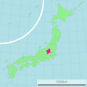
Governor =Masaaki Osawa Japan located in the northwest corner of theKantō region onHonshū island . Its capital isMaebashi .History
The remains of a
Paleolithic manFact|date=January 2008 were found atIwajuku , Gunma Prefecture, in the early 20th century and there is a public museum there.Japan was without horses until around the early centuries AD, and present-day Gunma was a center of the horsebreeding and trading activities when continental peoples and Japanese began a strong trade in the animals.
When Mt Haruna erupted in the late 6th century Japan was still in pre-history, but the Gunma Prefectural archaeology unit in 1994 was able to date the eruption through zoological anthropology at the corral sites that were buried in ash.
In the past, Gunma was joined with
Tochigi Prefecture and called "Kenu Province". This was later divided into "Kami-kenu" (Upper Kenu, Gunma) and "Shimo-kenu" (Lower Kenu, Tochigi). The area is sometimes referred to as Jomo (上毛, "Jōmō"). For most of Japanese history, Gunma was known as the province of Kozuke.In the early period of contact between western nations and Japan, particularly the late Tokugawa, it was referred to by foreigners as the "Joushu States", inside (fudai, or loyalist) Tokugawa retainers and the Tokugawa family symbol is widely seen at public buildings, temples and shrines.
The first modern silk factories were built with Italian and French assistance at Annaka in the 1870s.
In the early Meiji period, a bloody political struggle between idealistic democratic westernizers and conservative Prussian-model nationalists took place in Gunma and neighboring Nagano. This was locally called the Gunma Incident of 1884. In it the modern Japanese army gunned down the farmers with their new Japanese-built repeating rifles. It is said that the farmers of Gunma were the first victims of the Murata rifle.
In the twentieth century, the Japanese aviation pioneer Nakajima Chikushi of Oizumi, Gunma Prefecture, founded Nakajima Aircraft. At first he produced mostly licensed models of foreign designs, but beginning with the famous all- Japanese Nakajima 91 fighter plane of 1931 his firm became a world leader in aeronautical design and manufacture, with its headquarters at Ota, Gunma Ken.That factory now produces Subaru motorcars and many other industrial products under the Fuji Heavy Industries name.
In the 1930s, the great German architect Bruno Julius Florian Taut (
May 4 ,1880 , Königsberg, Germany -December 24 ,1938 , Istanbul) lived for a while and did research in Takasaki, Gunma Ken.The
Girard Incident , which disturbed US-Japanese relations in the 1950s, occurred in Gunma in 1957, at Somogahara Base near Shibukawa.Gunma has produced four modern Prime Ministers of Japan;Takeo Fukuda ,Yasuhiro Nakasone ,Keizo Obuchi , andYasuo Fukuda , the son of Takeo.Geography
One of only eight landlocked prefectures in Japan, Gunma is the northwestern-most prefecture of the Kantō plain. Except for the central and southeast areas, where most of the population is concentrated, it is mostly mountainous. To the north are Niigata and Fukushima prefectures, while to the east lies Tochigi. To the west lies
Nagano prefecture , and Saitama is to the south.Some of the major mountains in Gunma are
Mount Akagi ,Mount Haruna ,Mount Myōgi ,Mount Nikkō-Shirane andMount Asama , which is located on the Nagano border. The first three are known as the "Three Mountains of Jōmō." Major rivers include theTone River , theAgatsuma River , and theKarasu River .Cities
Twelve cities are located in Gunma Prefecture:
*Annaka
*Fujioka
*Isesaki
*Kiryū
*Maebashi (capital)
*Midori
*Numata
*Ōta
*Shibukawa
*Takasaki
*Tatebayashi
*TomiokaTowns and villages
Towns and villages in each district:
Mergers
Climate
Because Gunma is situated in inland Japan, the difference in temperature in the summer compared to the winter is large, and there is less precipitation. This is because of the "kara-kaze", a strong, dry wind which occurs in the winter when the snow falls on the coasts of Niigata. The wind carrying clouds with snow bang into the
Echigo Mountain Range , and it also snows there, although the high peaks do not let the wind go past them. For this reason, the wind changes into the kara-kaze.* Climate in
Maebashi
** Average yearly precipitation: 1,163 mm
** Average yearly temperature: 14.2 degrees CelsiusEconomy
Gunma's modern industries include transport equipment and electrical equipment, concentrated around Maebashi and the eastern region nearest
Tokyo . More traditional industries include sericulture andagriculture . As for agriculture, Gunma's major products includecabbages and konjacs. Gunma produces 90% of Japan's konjacs, and two-thirds of the farms in the village of Tsumagoi are cabbage farms. Also, the city of Ōta is famous for car industry, notably theSubaru factory.Culture
Gunma has a traditional card game called Jomo Karuta (上毛かるた). Both children and old people can enjoy this card game.
Mitsuru Adachi , one of the most famous Japanese manga writers, well-known for "Touch" and "H2",was born in Gunma.Sports
The sports teams listed below are based in Gunma.
Football (soccer)
*Thespa Kusatsu (Kusatsu)
*Arte Takasaki (Takasaki)Rugby
*Sanyo Wild Knights (Ota)Gunma is also famous for its ski resorts in the mountains, which attracts many tourists.
Tourism
Many places in Gunma are famous for their hot spring resorts. Another draw to the mountainous Gunma is the ski resorts.
Other attractions include:
*Lake Nozori
*Hara Museum Arc
*Ikaho Sistina Trick Art Museum
*Mount Haruna
*Kusatsu Alpine-Plant Museum
*Kusatsu Hot-Spring Museum
*Mount Kusatsu-Shirane
*Mount Tanigawa
*Mount Akagi Prefectural symbols
The prefectural symbol consists of the first
kanji of the word 'Gunma' surrounded by three stylized mountains symbolizing the three important mountains of Gunma Prefecture:Mount Haruna ,Mt. Akagi , and Mt. Myogi.For Marketing, The Prefectural Government also uses Yuma-chan, a small
super deformed drawing of a horse character wearing green cap. He is used on promotional posters, banners and other notable printed matierals from the Prefectural Government. Other agencies and companies formally or informally use variations of his likeness and other horse shaped characters when making signs or notices for work on buildings, roads, and other public notices.References
*cite web | title="Gunma Prefecture: Location and Topography" | work=Gunma Prefecture HomePage | url=http://www.pref.gunma.jp/english/location/index.htm | date=2006-10 | accessdate=2006-10-19
External links
* [http://www.pref.gunma.jp/english/index.html Official Gunma Prefecture homepage]
* [http://www.bae.se/kitayama/10gunma.htm Railways in Gunma]

Wikimedia Foundation. 2010.