Otterburn (Bedford, Virginia) — Otterburn U.S. National Register of Historic Places … Wikipedia
Battle of Otterburn — Infobox Military Conflict conflict=Battle of Otterburn partof=Anglo Scottish border conflicts caption= date=5 August or 19 August, 1388 place=1 mile northwest of Otterburn, Northumberland result=Scottish victory combatant1=Scotland… … Wikipedia
National Register of Historic Places listings in Bedford County, Virginia — Map of all coordinates from Google Map of all coordinates from Bing … Wikipedia
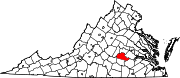
Amelia County, Virginia — Seal … Wikipedia
List of Registered Historic Places in Virginia, Counties A-B — List of Registered Historic Places in Virginia: NOTOC :: Virginia NRHP date for lists =Accomack County= * Accomac ** Accomac Historic District ** Bank Building ** Bowman s Folly ** Debtors Prison ** St. James Church * Assawoman ** Arbuckle Place… … Wikipedia
National Register of Historic Places listings in Amelia County, Virginia — Map of all coordinates from Google Map of all coordinates from Bing … Wikipedia
Chula, Virginia — Chula is an unincorporated community located in Amelia County, in the U.S. state of Virginia. Reference U.S. Geological Survey Geographic Names Information System: Chula, Virginia … Wikipedia
Clementown Mills, Virginia — Clementown Mills is an unincorporated community located in Amelia County, in the U.S. state of Virginia. Reference U.S. Geological Survey Geographic Names Information System: Clementown Mills, Virginia … Wikipedia
Coverly, Virginia — Coverly is an unincorporated community located in Amelia County, in the U.S. state of Virginia. Reference U.S. Geological Survey Geographic Names Information System: Coverly, Virginia … Wikipedia
Deatonville, Virginia — Deatonville is an unincorporated community located in Amelia County, in the U.S. state of Virginia. Reference U.S. Geological Survey Geographic Names Information System: Deatonville, Virginia … Wikipedia