- National Register of Historic Places listings in Lenoir County, North Carolina
-

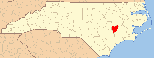
This list includes properties and districts listed on the National Register of Historic Places in Lenoir County, North Carolina. Click the "Map of all coordinates" link to the right to view a Google map of all properties and districts with latitude and longitude coordinates in the table below.[1]
-
- This National Park Service list is complete through NPS recent listings posted November 10, 2011.[2]
[3] Landmark name[4] Image Date listed Location City or Town Summary 1 American Tobacco Company Prizery April 28, 2005 619 North Herritage Street
35°16′9″N 77°34′57″W / 35.26917°N 77.5825°WKinston 2 Atlantic and North Carolina Railroad Freight Depot November 8, 1989 East Blount Street between North Queen and North McLewean Streets
35°15′47″N 77°34′49″W / 35.26306°N 77.58028°WKinston 3 Baptist Parsonage November 8, 1989 211 South McLewean Street
35°15′28″N 77°34′48″W / 35.25778°N 77.58°WKinston 4 Robert L. Blalock House November 8, 1989 300 South McLewean Street
35°15′25″N 77°34′47″W / 35.25694°N 77.57972°WKinston 5 B. W. Canady House November 8, 1989 600 North Queen Street
35°15′59″N 77°34′54″W / 35.26639°N 77.58167°WKinston 6 Cedar Dell August 26, 1971 Southeast of Falling Creek on SR 1338
35°15′17″N 77°41′20″W / 35.25472°N 77.68889°WFalling Creek 7 CSS NEUSE (Ironclad Gunboat) June 11, 2001 2612 West Vernon Avenue
35°16′1″N 77°37′18″W / 35.26694°N 77.62167°WKinston 8 Herring House October 25, 1973 Northwest of La Grange off SR 1503
35°19′44″N 77°48′22″W / 35.32889°N 77.80611°WLa Grange 9 Hill-Grainger Historic District November 8, 1989 Roughly bounded by Summit Avenue, North East Street, East and West Vernon Avenue, and North Heritage Street
35°16′17″N 77°34′47″W / 35.27139°N 77.57972°WKinston 10 Hotel Kinston November 8, 1989 503 North Queen Street
35°15′54″N 77°34′52″W / 35.265°N 77.58111°WKinston 11 Jesse Jackson House June 24, 1971 Southeast of Kinston on NC 11
35°13′33.37″N 77°38′39.68″W / 35.2259361°N 77.6443556°WKinston 12 Kennedy Memorial Home Historic District September 3, 2009 2557 Ceder Dell Lane
35°15′17″N 77°41′33″W / 35.25472°N 77.6925°WKinston 13 Kinston Apartments June 22, 2004 1313 McAdoo Street
35°16′40″N 77°34′42″W / 35.27778°N 77.57833°WKinston 14 Kinston Baptist-White Rock Presbyterian Church November 8, 1989 516 Thompson Street
35°15′54″N 77°34′22″W / 35.265°N 77.57278°WKinston 15 Kinston Battlefield November 30, 2006 1.5 miles (2.4 km) south of Kinston on US 258; 2 to 3 miles (3.2 to 4.8 km) south of Kinston on US 258; 3 miles (4.8 km) south of Kinston on NC 58; 4 miles (6.4 km) south of Kinston on US 258
35°13′41″N 77°36′36″W / 35.22806°N 77.61°WKinston 16 Kinston Fire Station-City Hall November 8, 1989 118 South Queen Street
35°15′34″N 77°34′53″W / 35.25944°N 77.58139°WKinston 17 LaGrange Historic District May 11, 2000 Roughly bounded by North Caswell, East James, North Carey, East Washington, South Caswell, West Washington, and Forbes Streets
35°18′20″N 77°47′30″W / 35.30556°N 77.79167°WLa Grange 18 LaGrange Presbyterian Church August 14, 1986 201 South Caswell Street
35°18′17″N 77°47′21″W / 35.30472°N 77.78917°WLa Grange 19 Lenoir County Courthouse May 10, 1979 Queen and Kings Streets
35°15′30″N 77°34′25″W / 35.25833°N 77.57361°WKinston 20 Mitchelltown Historic District November 8, 1989 Roughly bounded by West Vernon Avenue, North Heritage Street, West Blount Street, College Street, Atlantic Avenue, and Rhem Street
35°15′58″N 77°35′13″W / 35.26611°N 77.58694°WKinston 21 Peebles House August 26, 1971 109 East King Street
35°15′33″N 77°34′59″W / 35.25917°N 77.58306°WKinston 22 Queen-Gordon Streets Historic District November 8, 1989 Roughly bounded by East Blount, West Blount, North Herritage, West North and North Queen Streets; also roughly bounded by E. Blount, W. Blount, N. Heritage, W. North, and N. Queen Sts.
35°15′43″N 77°34′52″W / 35.26194°N 77.58111°WKinston Second set of boundaries represents a boundary increase of June 3, 1994, the Kinston Commercial Historic District 23 Sumrell and McCoy Building December 21, 1989 400 North Queen Street
35°15′49″N 77°34′54″W / 35.26361°N 77.58167°WKinston 24 Trianon Historic District November 8, 1989 Roughly East Gordon Street from North Tiffany to North Orion Streets and Water Street from North Vance to North Orion Streets
35°15′40″N 77°34′15″W / 35.26111°N 77.57083°WKinston 25 Tull-Worth-Holland Farm September 22, 1992 NC 1579 north side, 0.5 miles (0.80 km) east of junction with NC 1578
35°18′54″N 77°35′30″W / 35.315°N 77.59167°WKinston 26 Dempsey Wood House August 26, 1971 Southwest of Falling Creek on SR 1324
35°13′51″N 77°43′28″W / 35.23083°N 77.72444°WKinston See also
- National Register of Historic Places listings in North Carolina
- List of National Historic Landmarks in North Carolina
References
- ^ The latitude and longitude information provided in this table was derived originally from the National Register Information System, which has been found to be fairly accurate for about 99% of listings. For about 1% of NRIS original coordinates, experience has shown that one or both coordinates are typos or otherwise extremely far off; some corrections may have been made. A more subtle problem causes many locations to be off by up to 150 yards, depending on location in the country: most NRIS coordinates were derived from tracing out latitude and longitudes off of USGS topographical quadrant maps created under the North American Datum of 1927, which differs from the current, highly accurate WGS84 GPS system used by Google maps. Chicago is about right, but NRIS longitudes in Washington are higher by about 4.5 seconds, and are lower by about 2.0 seconds in Maine. Latitudes differ by about 1.0 second in Florida. Some locations in this table may have been corrected to current GPS standards.
- ^ "National Register of Historic Places: Weekly List Actions". National Park Service, United States Department of the Interior. Retrieved on November 10, 2011.
- ^ Numbers represent an ordering by significant words. Various colorings, defined here, differentiate National Historic Landmark sites and National Register of Historic Places Districts from other NRHP buildings, structures, sites or objects.
- ^ "National Register Information System". National Register of Historic Places. National Park Service. 2008-04-24. http://nrhp.focus.nps.gov/natreg/docs/All_Data.html.
U.S. National Register of Historic Places Topics Lists by states Alabama • Alaska • Arizona • Arkansas • California • Colorado • Connecticut • Delaware • Florida • Georgia • Hawaii • Idaho • Illinois • Indiana • Iowa • Kansas • Kentucky • Louisiana • Maine • Maryland • Massachusetts • Michigan • Minnesota • Mississippi • Missouri • Montana • Nebraska • Nevada • New Hampshire • New Jersey • New Mexico • New York • North Carolina • North Dakota • Ohio • Oklahoma • Oregon • Pennsylvania • Rhode Island • South Carolina • South Dakota • Tennessee • Texas • Utah • Vermont • Virginia • Washington • West Virginia • Wisconsin • WyomingLists by territories Lists by associated states Other Municipalities and communities of Lenoir County, North Carolina City 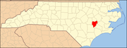
Towns Unincorporated
communityFootnotes ‡This populated place also has portions in an adjacent county or counties
Categories:- Lenoir County, North Carolina
- National Register of Historic Places in North Carolina
- Buildings and structures in Lenoir County, North Carolina
-
Wikimedia Foundation. 2010.