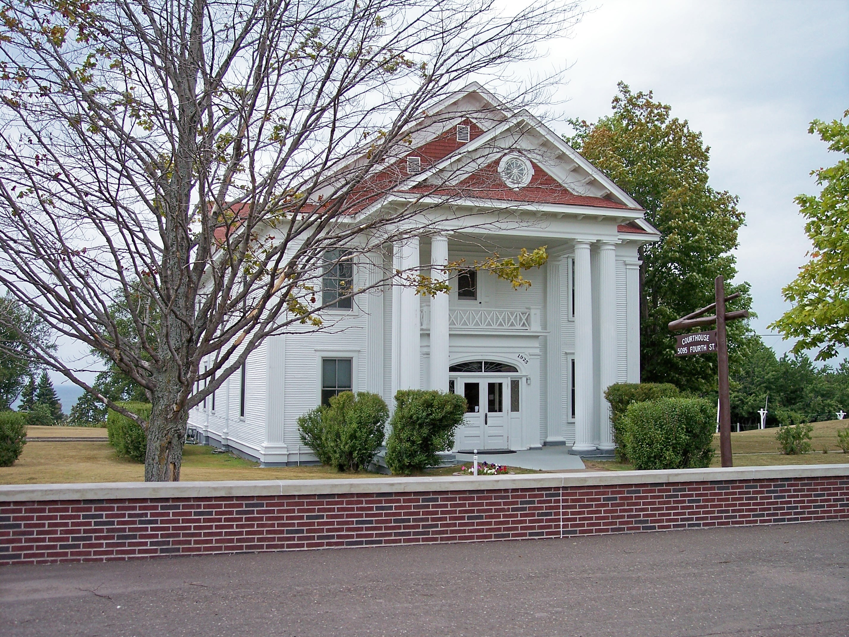
- National Register of Historic Places listings in Keweenaw County, Michigan
-

The following is a list of Registered Historic Places in Keweenaw County, Michigan.
-
- This National Park Service list is complete through NPS recent listings posted November 10, 2011.[1]
Early history
Copper was discovered in the Keweenaw in the 1830s; soon after, the US government built Fort Wilkins near Copper Harbor to maintain order in the area. Keweenaw County was split off from Houghton County in 1861, with the county seat in Eagle River.[2] The early government and commercial buildings in Eagle River are now a Historic District. Isle Royale, although split off into its own county in 1875, was reunited with Keweenaw County ten years later, and remains part of the county.
Mining
Like Houghton County to the south, Keweenaw County's history includes much reference to copper mining.[2] In particular, one of the earliest mines in the area, the prehistoric Minong Mine on Isle Royale, is listed as a historic district. In addition, the Central Mine and its Methodist Church are also listed on the historic register.
Shipping and Transportation
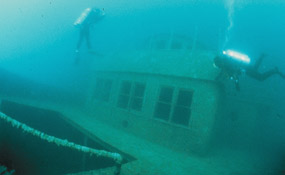
However, with the greatest Great Lake, Lake Superior, surrounding the peninsula, and muiltiple natural harbors, Keweenaw County's history is much more entwined in shipping and transportation. Eighteen of the properties listed--over half--were directly related to Great Lakes shipping. These include eight lighthouses in Lake Superior: Eagle Harbor Light, Gull Rock Light Station, Isle Royale Light, Manitou Island Light Station, Passage Island Light Station, Rock Harbor Light, Rock of Ages Light, and Sand Hills Light. In addition, the wrecks of ten ships around Isle Royale are on the Register: The SS Algoma, SS America, Chester A. Congdon, SS Cumberland, SS Emperor, George M. Cox, SS Glenlyon, SS Henry Chisholm, SS Kamloops, and the SS Monarch.
In addition, the listings contain three road bridges built in the 1930s: the M 26-Cedar Creek Culvert, the M26-Silver River Culvert, and the US 41 – Fanny Hooe Creek Bridge. Finally, the Houghton County Traction Company Ahmeek Streetcar Station, an interurban rail station, represents local transportation in the Keweenaw.
Tourism
As the mining industry in the Keweenaw ran down, tourism in the area increased. This was evidenced by the increase in passenger ships (natably the SS America, mentioned above) and the construction of tourist hotels and summer cottages such as the Johns Hotel, the first resort on Isle Royale, and the Keweenaw Mountain Lodge and Golf Course Complex, built in 1933-34. Also in the 1930s, the roads accessing the Keweenaw communities were improved, with the addition of bridges such as the US 41 – Fanny Hooe Creek Bridge.
[3] Site name[4] Image Date listed Location City or Town Summary 1 ALGOMA 
June 14, 1984 Southeast shore of Mott Island
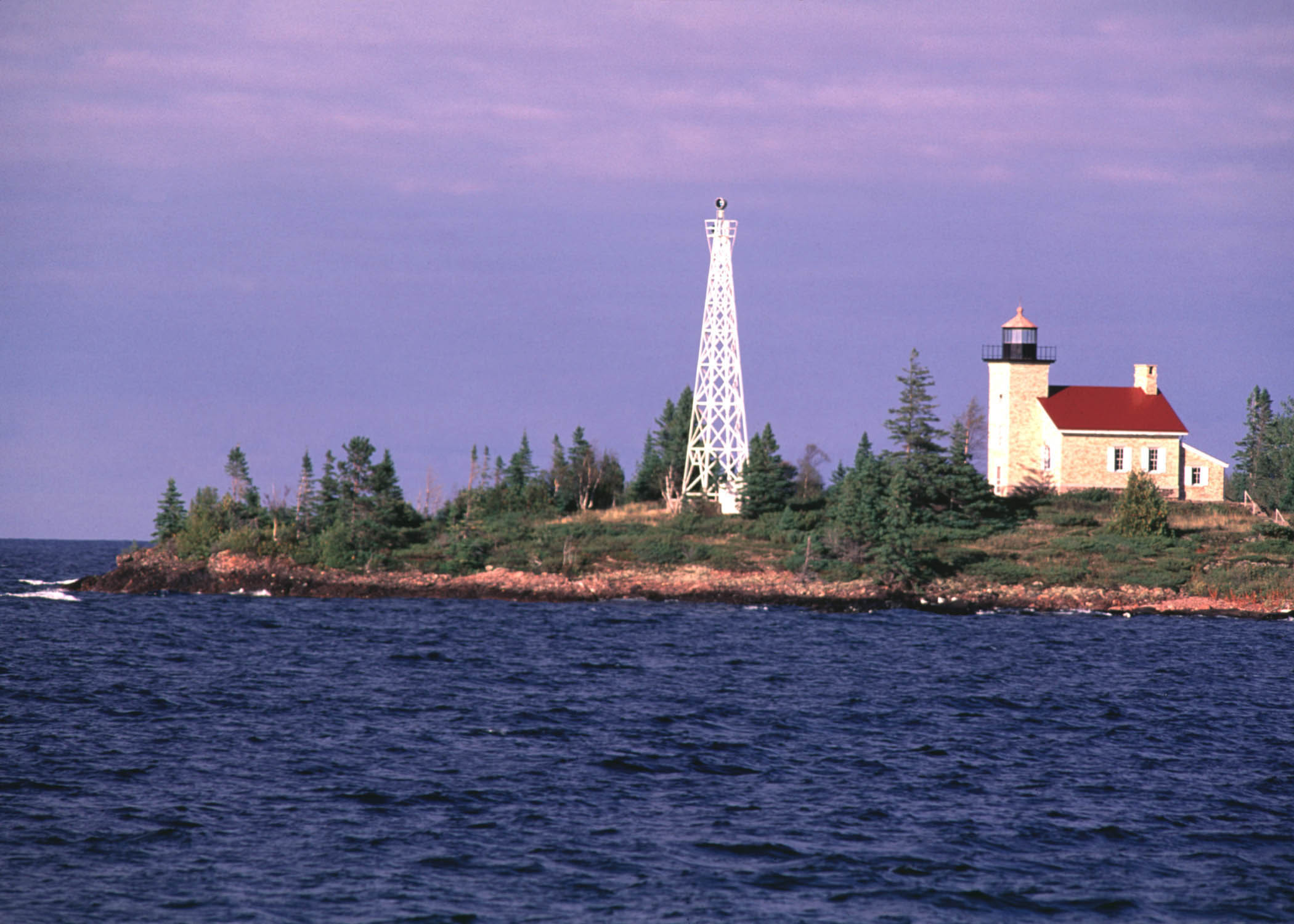
48°6′41″N 88°31′55″W / 48.11139°N 88.53194°W[5]Isle Royale National Park The Algoma was a passenger steamer built in 1883. In November 1885, it ran into a blinding snowstorm, veered off course, and ran aground near Isle Royale. As the storm continued to rage, the ship came apart, eventually killing 46 people. The wreck of the Algoma was the worst loss of life in the history of Lake Superior shipping. 2 AMERICA 
June 14, 1984 North Gap of Washington Harbor
47°53′39″N 89°13′15″W / 47.89417°N 89.22083°W[5]Isle Royale National Park The America served as a communications link for the communities of western Lake Superior in the early 20th century. Beginning in 1902, she ran three voyages per week among Duluth, Minnesota, Isle Royale, and Thunder Bay, Ontario, as well as numerous small communities in between. In June 1928, the America ran aground while leaving Washington Harbor, and efforts to salvage her were unsuccessful. The ship can be seen from the surface, with her bow in only two feet of water. 3 Central Mine Historic District 
June 28, 1974 US 41
47°24′21″N 88°11′58″W / 47.40583°N 88.19944°WCentral Central Mine was an active copper mine between 1856 and 1898, and over this span the company built 130 structures for use by the mine and its workers. Around 20 structures, mostly houses, remain. 4 Central Mine Methodist Church 
October 15, 1970 Old Stage Rd.
47°24′25″N 88°12′13″W / 47.40694°N 88.20361°WCentral This church, completed in 1869, was an important community center for the mining town of Central. After the mine closed in 1898, ex-residents and their descendents held an annual reunion at the church that continues into the 21st century. 5 CHESTER A. CONGDON 
June 14, 1984 Congdon Shoals on northeast end of Isle Royale
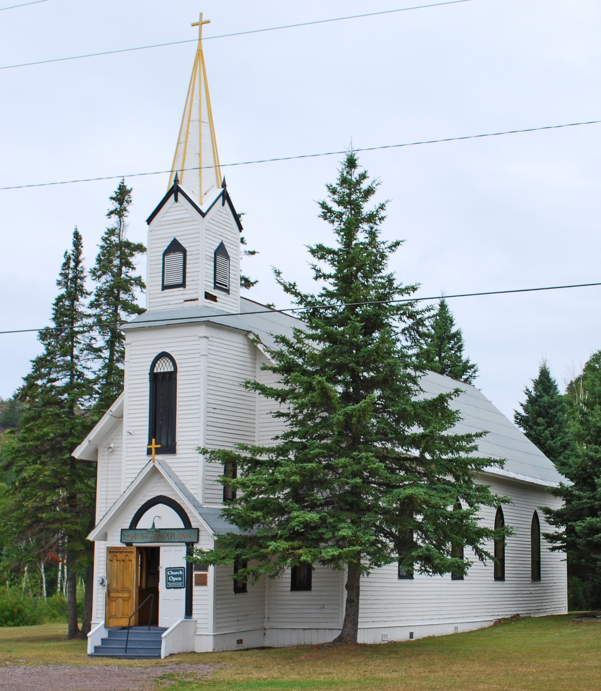
48°11′36″N 88°30′52″W / 48.19333°N 88.51444°W[5]Isle Royale National Park Originally named the Salt Lake City, when constructed in 1907, the bulk steel freighter sank near Isle Royale in Lake Superior in 1918. It was the first wreck in Lake Superior to be valued at over one million dollars. 6 Church of the Assumption 
March 15, 2000 US 41, east of M-26
47°23′22″N 88°16′34″W / 47.38944°N 88.27611°WHoughton Township Built in 1858 in Cliff as St. Mary's Catholic Church, in 1899 the church was dismantled and reconstructed in its present location in Phoenix. Masses were held in the church until 1957. The church is also known as the Phoenix Church. 7 CUMBERLAND 
June 14, 1984 Near Rock of Ages Light
47°51′28″N 89°19′32″W / 47.85778°N 89.32556°W[5]Isle Royale National Park The Cumberland was a wooden-hulled side paddlewheeler built in 1871. In July 1877, she began taking on water after leaving Thunder Bay, and struck a reef near the Rock of Ages Light. The day was clear and dry, and passengers and crew were removed without difficulty. The wreckage of the Cumberland is intermingled with some portions of the hull of the Henry Chisholm, which sank later in 1898. 8 Eagle Harbor Light Station 
July 19, 1984 Eagle Harbor
47°27′36″N 88°9′33″W / 47.46°N 88.15917°WEagle Harbor The original Eagle Harbor Light was built in 1851. The current structure with octagonal tower and associated keeper's house was built in 1871. In 1999 ownership was transferred to the Keweenaw County Historical Society, although the Coast Guard still operates the light. 9 Eagle Harbor Schoolhouse 
September 22, 1972 Third and Center[6]
47°27′24″N 88°9′46″W / 47.45667°N 88.16278°WEagle Harbor The Eagle Harbor Schoolhouse was the location where Justus H. Rathbone was first inspired to write the ritual which was the basis of the Order of the Knights of Pythias. 10 Eagle River Historic District 
September 13, 1984 Roughly Front, 2nd, 3rd, 4th, 5th, and Main Sts.
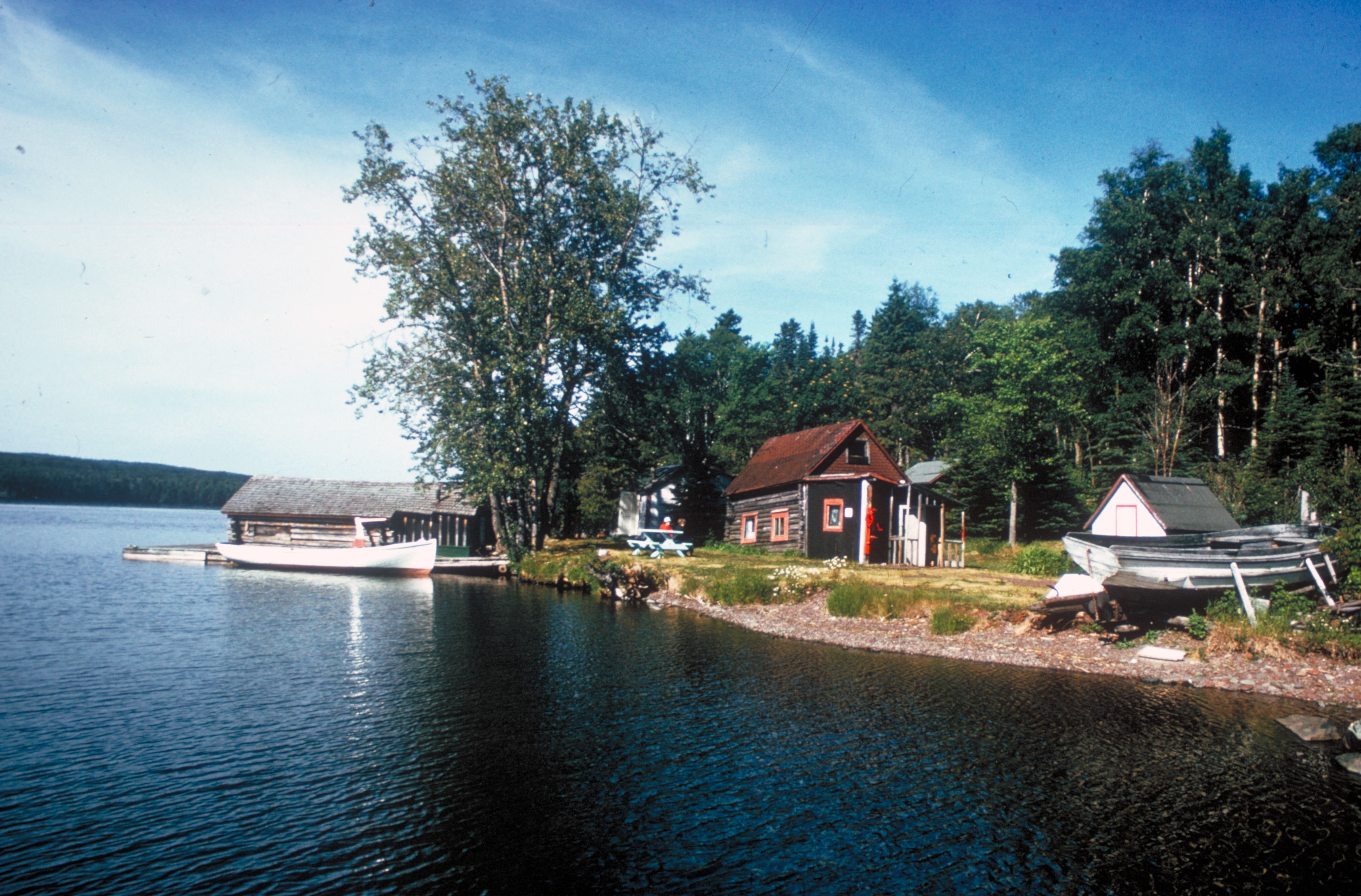
47°24′48″N 88°17′48″W / 47.41333°N 88.29667°WEagle River The community of Eagle River was founded in 1843. The District includes most of the remaining structures dating from the early settlement of the community, including industrial plants, county buildings, commercial buildings, and private residences. 11 Edisen Fishery 
March 8, 1977 Rock Harbor
48°5′22″N 88°34′57″W / 48.08944°N 88.5825°WIsle Royale National Park The Edisen Fishery is a collection of seven buildings making up a commercial fishery, constructed between 1895 and 1934 by local fishermen using easily available local materials and built using strictly functional designs. 12 EMPEROR 
June 14, 1984 North side of Canoe Rocks, on the northeast end of Isle Royale
48°12′2″N 88°29′30″W / 48.20056°N 88.49167°W[5]Isle Royale National Park The Emperor was a freighter constructed in 1910, and at 525 feet in length, it was the largest Canadian-built freighter ever built at the time of her launching. In June 1947, the Emperor left Thunder Bay, laden with 10,429 tons of iron ore. Her course was miscalculated, and the ship ran aground at 4:15 in the morning on the north side of Canoe Rocks. The Emperor sank within 30 minutes, killing twelve crewmembers. 13 Fort Wilkins 
July 8, 1970 Fort Wilkins State Park
47°28′26″N 87°52′5″W / 47.47389°N 87.86806°WCopper Harbor The U.S. Army first occupied Fort Wilkins in 1844, help with local law enforcement and to keep the peace between miners and the local Ojibwas. The fort was abandoned in 1846, and reoccupied only temporarily from 1867-1870. It is now a Michigan state park. 14 GEORGE M. COX 
June 14, 1984 Near Rock of Ages Light
47°51′28″N 89°19′32″W / 47.85778°N 89.32556°W[5]Isle Royale National Park The Cox was launched in 1901 as the USS Puritan, a civilian transport ship. It was used by the US Navy in World War I, but returned to civilian service afterward. It sank in 1933 near the Rock of Ages Light off Isle Royale in Lake Superior. 15 GLENLYON 
June 14, 1984 Glenlyon Shoals off Menagerie Island in Siskiwit Bay
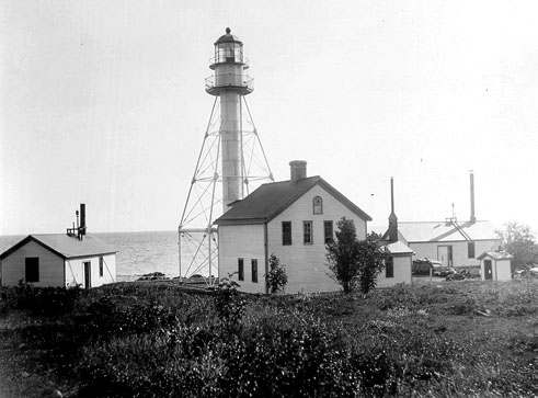
47°57′8″N 88°44′53″W / 47.95222°N 88.74806°W[5]Isle Royale National Park The Glenlyon was a freighter built in 1893. Over its career, it was owned by many companies, and hauled both package freight and bulk cargo, as well as, for a short time, passengers for both U.S. and Canada. The ship ran aground on November 1, 1924, while heading for shelter in Siskiwit Bay. 16 Gull Rock Light Station 
July 19, 1984 Gull Rock
47°25′2″N 87°39′49″W / 47.41722°N 87.66361°WCopper Harbor The Gull Rock Light Station is a lighthouse located on Gull Rock, just east of Manitou Island (Lake Superior) near Isle Royale in Lake Superior. The light was built in 1867, automated in 1913, and is still an active navigational aid. 17 HENRY CHISHOLM 
June 14, 1984 Near Rock of Ages Light
47°51′28″N 89°19′32″W / 47.85778°N 89.32556°W[5]Isle Royale National Park The Henry Chisholm was a wooden freighter built in 1880, and was the largest wooden "steam barge" ever built in Cleveland, approaching the practical size limit for a wooden vessel of its type. In October 1898, the Chisholm left Duluth, Minnesota, towing the 220-foot schooner John Martin. A storm blew up and the Martin was cast off. After the gale lessened, the Chisholm spent the next few days searching for the Martin, and struck a reef near the Rock of Ages Light while attempting to enter Washington Harbor. Portions of the Chisholm's hull are intermingled with the wreckage of the SS Cumberland, which had sunk earlier in 1877. 18 Holy Redeemer Church 
March 16, 1972 Western end of Center St.
47°27′24″N 88°9′54″W / 47.45667°N 88.165°WEagle Harbor Built in 1854, the church the oldest surviving Roman Catholic church in the Marquette Diocese. The church sat vacant for many years after the decline of the copper mining industry, but near the end of the 20th century was refurbushed and used for summer services. 19 Houghton County Traction Company Ahmeek Streetcar Station 
March 15, 2000 US 41/M-26 and Hubbell St.
47°17′48″N 88°23′42″W / 47.29667°N 88.395°WAhmeek The Houghton County Traction Company was started in 1900 as an interurban line in the Keweenaw Peninsula. By 1908 the line was extended to just north of Mohawk, with stops in communities such as Ahmeek along the way. The company folded in 1932. 20 Isle Royale Light Station 
August 4, 1983 Managerie Island
47°56′29″N 88°46′1″W / 47.94139°N 88.76694°WIsle Royale The Isle Royale Light (also called the Menagerie Island Light) is located on Managerie Island, at the opening of Siskiwit Bay near the southern shore of Isle Royale in Lake Superior. It was constructed in 1875. 21 Johns Hotel 
August 8, 1997 Washington Harbor, on Barnum Island
47°52′43″N 89°13′58″W / 47.87861°N 89.23278°WIsle Royale National Park The Johns Hotel was established in 1892, and was the first summer resort on Isle Royale. There were once 16 buildings o nthe site, of which two, the main hotel and one cabin, remain. 22 KAMLOOPS 
June 14, 1984 Kamloops Point
48°5′6″N 88°45′53″W / 48.085°N 88.76472°W[5]Isle Royale National Park The SS Kamloops was a lake freighter that was part of the fleet of Canada Steamship Lines from its launching in 1924 until it sank with all hands off Isle Royale in Lake Superior on or about 7 December 1927. 23 Keweenaw Mountain Lodge and Golf Course Complex 
June 18, 1980 Southwest of Copper Harbor on US 41
47°27′28″N 87°54′27″W / 47.45778°N 87.9075°WCopper Harbor The lodge was built in 1933/34 using funding from the newly minted Civil Works Administration. Logs from the forest cleared on the property were used to build the structures in the complex. 24 M 26-Cedar Creek Culvert 
December 17, 1999 M-26 over Cedar Creek
47°27′20″N 88°9′0″W / 47.45556°N 88.15°WEagle Harbor Township The M 26-Cedar Creek Culvert is a highway bridge located on M-26 over Cedar Creek, built by the Keweenaw County Road Commission in 1930. 25 M26-Silver River Culvert 
December 17, 1999 M-26 over Silver River
47°27′47″N 88°4′20″W / 47.46306°N 88.07222°WEagle Harbor Township The M 26-Silver River Culvert is a highway bridge located on M-26 over the Silver River, built by the Keweenaw County Road Commission in 1930. 26 Manitou Island Light Station 
July 19, 1984 Manitou Island
47°25′12″N 87°35′14″W / 47.42°N 87.58722°WCopper Harbor The Manitou Island Light Station is a lighthouse located on Manitou Island, off the tip of Michigan's Keweenaw Peninsula in Lake Superior. The station consists of a skeletal steel light tower with associated keeper's house, both built in 1861. 27 Minong Mine Historic District 
November 11, 1977 West of McCargoe Cove campground
48°4′58″N 88°43′35″W / 48.08278°N 88.72639°W[7]Isle Royale National Park The Minong Mine site contains prehistoric copper mining pits, thought to be as old as 4500 years. In addition, the site contains the remains of the Minong Mine, a 19th century copper mine that produced 249 tons of copper over its ten years of existence. 28 MONARCH 
June 14, 1984 Palisade area on the north side of Blake Point
48°11′20″N 88°26′3″W / 48.18889°N 88.43417°W[5]Isle Royale National Park The Monarch was a passenger-package freighter built in 1890. In December 1906, the departed Thunder Bay for Sarnia in a blinding snowstorm. For some reason, the ship headed off its planned course, and that night it rammed at full speed into the palisade area on the north side of Blake Point on Isle Roayale. Miraculously, all but one of the crew and passengers were able to make it to shore. 29 Passage Island Light Station 
July 19, 2006 Southwestern end of Passage Island, 3.25 mi (5.23 km) northeast of Isle Royale in northwestern Lake Superior
48°13′27″N 88°21′57″W / 48.22417°N 88.36583°WHoughton Township The Passage Island Light Station is a lighthouse located 3.25 mi NE of Isle Royale, in Lake Superior. It was constructed in 1882. 30 Rock Harbor Lighthouse 
March 8, 1977 Rock Harbor
48°5′21″N 88°34′45″W / 48.08917°N 88.57917°WIsle Royale National Park The Rock Harbor Lighthouse is located in Rock Harbor on Isle Royale in Lake Superior. It was built in 1855/56, but permanently extinguished in 1879. 31 Rock of Ages Light Station 
August 4, 1983 Southwest of Isle Royale
47°51′34″N 89°19′30″W / 47.85944°N 89.325°WIsle Royale The Rock of Ages Light is an active lighthouse on a small rock outcropping approximately 5 mi (8.0 km) west of Isle Royale in Lake Superior. It was constructed in 1908. 32 Sand Hills Light Station 
July 27, 1994 Five Mile Point Rd., north of Mohawk, Allouez Township
47°23′29″N 88°22′0″W / 47.39139°N 88.366667°WMohawk Sand Hills is a formerly active lighthouse on the shore of Lake Superior. It was built in 1919 and decommissioned in 1954; the structure is now a bed and breakfast. 33 US 41 – Fanny Hooe Creek Bridge 
December 17, 1999 US 41 over Fanny Hooe Creek
47°28′1″N 87°52′18″W / 47.46694°N 87.87167°WGrant Township The US 41 – Fanny Hooe Creek Bridge is a highway bridge located on US 41 over the Fanny Hooe Creek, adjacent to Fort Wilkins State Park. It was constructed by the Keweenaw County Road Commission in 1928. See also
- List of Registered Historic Places in Michigan
References
- ^ "National Register of Historic Places: Weekly List Actions". National Park Service, United States Department of the Interior. Retrieved on November 10, 2011.
- ^ a b Alvah Littlefield Sawyer (1911), A history of the northern peninsula of Michigan and its people: its mining, lumber and agricultural industries, The Lewis Publishing Company, pp. 489-495, http://books.google.com/books?id=3YF5AAAAMAAJ&pg=PA489#v=onepage&q&f=false
- ^ Numbers represent an ordering by significant words. Various colorings, defined here, differentiate National Historic Landmark sites, a [[National Historic Site (United States)|]], and several National Register of Historic Places Districts from other NRHP buildings, structures, sites or objects.
- ^ "National Register Information System". National Register of Historic Places. National Park Service. 2008-04-24. http://nrhp.focus.nps.gov/natreg/docs/All_Data.html.
- ^ a b c d e f g h i j The ten shipwrecks off Isle Royale are listed as "address restricted." However, the Isle Royale National Park Diving makes it clear that the wrecks are open to diving, and the location information is listed at the "Scuba Diving Page". Isle Royale National Park. http://www.nps.gov/isro/planyourvisit/scuba-diving.htm. Retrieved Dedember 12, 2010.. Geo-coordinates are from "The Wrecks of Isle Royale". Black Dog Diving. http://www.mn-blackdogdiving.com/new_page_2.htm. Retrieved December 12, 2010., a dive company suggested by the National Park.
- ^ The NHIS database gives the location as "Block 10," while "Third and Center" comes from "Eagle Harbor Schoolhouse". State of Michigan. http://www.mcgi.state.mi.us/hso/sites/8121.htm.
- ^ The Minong Mine is listed as "address restricted." However, the Isle Royale National Park official map shows its location, and the park marks the trail to the mine.
U.S. National Register of Historic Places Topics Lists by states Alabama • Alaska • Arizona • Arkansas • California • Colorado • Connecticut • Delaware • Florida • Georgia • Hawaii • Idaho • Illinois • Indiana • Iowa • Kansas • Kentucky • Louisiana • Maine • Maryland • Massachusetts • Michigan • Minnesota • Mississippi • Missouri • Montana • Nebraska • Nevada • New Hampshire • New Jersey • New Mexico • New York • North Carolina • North Dakota • Ohio • Oklahoma • Oregon • Pennsylvania • Rhode Island • South Carolina • South Dakota • Tennessee • Texas • Utah • Vermont • Virginia • Washington • West Virginia • Wisconsin • WyomingLists by territories Lists by associated states Other Categories:- National Register of Historic Places in Michigan by county
- Keweenaw County, Michigan
-


Wikimedia Foundation. 2010.