- Isle Royale
Infobox Islands
name = Isle Royale
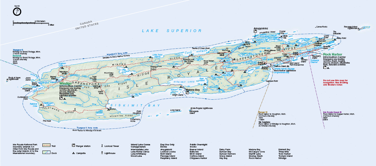
image caption = Map of Isle Royale
image size =
locator
Location map|Michigan|lat=48|long=-88.5
map_custom = yes
native name =
native name link =
nickname =
location =Lake Superior
coordinates = coord|48|0|N|88|55|W|display=inline
archipelago =
total islands =
major islands =
area = convert|206.73|sqmi|km2|2
length = convert|45|mi|km|0
width = convert|9|mi|km|0
highest mount =Mount Desor
elevation = convert|1394|ft|m|0
country = United States
country admin divisions title = State
country admin divisions = flag|Michigan
country admin divisions title 1 = County
country admin divisions 1 = Keweenaw County
country admin divisions title 2 =
country admin divisions 2 =
country largest city =
country largest city population =
population = 0
population as of = 2000
density =
ethnic groups =
additional info =Isle Royale is an island of the Great Lakes, located in the northwest of
Lake Superior . The island and the surrounding smaller islands and waters make upIsle Royale National Park . It is pronEng|ˌaɪlˈrɔɪəl, with a long I in Isle and the accent on the first syllable of Royale, not the second. [cite web | title = Definition of Isle Royale | work = Encyclopedia Britannica Online | publisher = Encyclopedia Britannica | url = http://www.britannica.com/dictionary?va=Isle+Royale&query=Isle+Royale | accessdate = 2007-04-04 ] In French, "Isle" is now spelled "Île".The island is convert|45|mi|km|0 long and convert|9|mi|km|0 wide, with an area of convert|206.73|sqmi|km2|2, making it the largest natural island in Lake Superior, the second largest island in the
Great Lakes afterManitoulin Island , and the 32nd largest island in the United States. It is defined by theUnited States Census Bureau as Census Tract 9603 ofKeweenaw County, Michigan . As of the 2000 census there was no permanent population. [ [http://factfinder.census.gov/servlet/DTTable?_bm=y&-show_geoid=Y&-tree_id=4001&-_caller=geoselect&-context=dt&-errMsg=&-all_geo_types=N&-mt_name=DEC_2000_SF1_U_P001&-redoLog=true&-transpose=N&-search_map_config=|b=50|l=en|t=4001|zf=0.0|ms=sel_00dec|dw=1.3521978874463578|dh=0.6806786847227801|dt=gov.census.aff.domain.map.EnglishMapExtent|if=gif|cx=-88.85864895383767|cy=48.03341512809439|zl=6|pz=6|bo=318:317:316:314:313:323:319|bl=362:393:358:357:356:355:354|ft=350:349:335:389:388:332:331|fl=381:403:204:380:369:379:368|g=05000US02290&-PANEL_ID=p_dt_geo_map&-_lang=en&-geo_id=14000US26083960300&-CONTEXT=dt&-format=&-search_results=01000US&-ds_name=DEC_2000_SF1_U Census Tract 9603, Keweenaw County] United States Census Bureau] After the island was made a national park, some existing residents were allowed to stay;cite web
last =Barnum
first =David C.
authorlink =
coauthors =
title = About Us
work =
publisher = Isle Royale Families and Friends Association
month =April | year =2002
url =http://www.isleroyalefamilies.org/aboutus.htm
format =
doi =
accessdate = 2007-12-09 ] and a few leases are still in effect. Ferries from Michigan and Minnesota land atRock Harbor on the eastern end of the island; this has a lodge, campground, and information center. Ferries from Minnesota also run toWindigo on the western end, which has a visitor center and campground.Isle Royale is
United States territory (even though it is closer to the Canadian coastline) and is part of the state ofMichigan (though it is much closer toMinnesota ). In 1875, Isle Royale was set off from Keweenaw County as a separate county, "Isle Royale County". In 1897, the county was dissolved, and the island was reincorporated into Keweenaw County. The highest point on the island isMount Desor at convert|1394|ft|m|0, or about convert|800|ft|m|-1 above lake level.Isle Royale is within about convert|15|mi|km|0 of the Canadian and Minnesotan shores of the lake, (near the city of
Thunder Bay, Ontario ), and is convert|56|mi|km|0 from the Michigan shore, on theKeweenaw Peninsula . There are seasonal passenger ferry services to the island fromGrand Portage, Minnesota ;Copper Harbor, Michigan ; andHoughton, Michigan . There is also a seasonal sea plane service. There are no roads on the island, and, in fact, no wheeled vehicles or devices, other than wheelchairs, are permitted. [cite web | title = "Isle Royale FAQ" | url = http://www.nps.gov/isro/faqs.htm | accessdate = 2007-04-08]History
The island was a common hunting ground for native peoples from nearby Minnesota/Ontario. A canoe voyage of only a few miles was necessary to reach the island's west end from the mainland.
In prehistoric times, large quantities of copper were mined on Isle Royale and the nearby
Keweenaw Peninsula . The region is scarred by ancient mine pits and trenches up to 20 feet deep.Carbon-14 testing of wood remains found in sockets of copper artifacts indicates that they are at least 5700 years old. In "Prehistoric Copper Mining in the Lake Superior Region," published in 1961, Drier and Du Temple estimated that over 1.5 billion pounds of copper had been mined from the region. However, David Johnson contends that their estimate was based on exaggerated assumptions. [http://copperculture.homestead.com/]The ancient miners may have used the following technique: (1) Fires were built atop the copper-bearing rock. (2) The heated rock was doused with water, and fractured from the rapid cooling. (3) Stone hammers were used to break the copper free from the fractured rock. [http://copperculture.homestead.com/]
Isle Royale was given to the United States by the 1783 treaty with England, but the English remained in control until after the
War of 1812 , and theOjibwa peoples considered the island to be their territory. The Ojibwas ceded the island to the U. S. in the 1842Treaty of La Pointe , with theGrand Portage Band not aware that they nor Isle Royale were in British territory. With the clarification to the Ojibwas of the 1842Webster-Ashburton Treaty that was signed before the Treaty of La Pointe, the Ojibwas re-affirmed the 1842 Treaty of La Pointe in the 1844Isle Royale Agreement , with the Grand Portage Band signing the agreement as an adhesion to 1842 treaty.In the mid 1840s, a report by
Douglass Houghton , Michigan's first stategeologist , set off a copper boom in the state, and the first modern copper mines were opened on the island.Harris, Ann G., et al. (2004). "Geology of National Parks" (6th ed.), p. 308. Kendall/Hunt Publishing Co. ISBN 0787299707.] Evidence of the earlier mining efforts was everywhere, in the form of many stone hammers, some copper artifacts, and places where copper had been partially worked out of the rock but left in place. The ancient pits and trenches led to the discovery of many of the copper deposits that were mined in the 19th century. [http://copperculture.homestead.com/] The remoteness of the island, combined with the small veins of copper, caused most of the 19th century mines to fail quickly.Fact|date=January 2008 Between the miners and commercial loggers, much of the island was deforested during the late 19th century. Once the island became a National Park in 1940, logging and other exploitive activities ended, and the forest began to regenerate.The island was once the site of several
lake trout and whitefish fisheries, as well as a few resorts. Today it has no permanent inhabitants; the small communities of Scandinavian fishermen were removed by the United States Park Service after the island became a national park in the 1930s. There are still a about 12 families that have life time leases for their cabins and claim Isle Royale as their heritage and several descendant fishermen still fish the Isle Royale waters commercially. The western tip of the island is home to several shipwrecks that are very popular with scuba divers, including the SS "America". [cite web | last = Merryman | first = Ken | title = SS America Shipwreck | publisher = Superior Trips | url = http://www.superiortrips.com/America_Shipwreck.htm | accessdate = 2007-04-04 ]Geography and geology
The island is composed largely of ridges, running roughly southwest-to-northeast. The main ridge, Greenstone Ridge, is over convert|1000|ft|m|-2 in many places. According to the National Park Service, the North sides of the ridges tend to be steeper than the South sides. Coastal areas were once submerged beneath prehistoric lake waters, and contain many tumbled boulders and other large rocks. Topsoil tends to be thin, which favors trees that have horizontal root patterns such as
Balsam Fir ,White Spruce ,Black Spruce , and Shell Bark Spruce.The ancient bedrock contained minor deposits of
native copper , few of which proved profitable to 19th century mining companies.Interior lakes
*
Chicken Bone Lake
*Lake Desor
*Feldtmann Lake
*Intermediate Lake
*Lake Ritchie
*Sargent Lake
*Siskiwit Lake , largest lake on the island; cold, deep, clear, and relatively low in nutrients. [cite book | last = Shelton | first = Napier | title = Superior Wilderness: Isle Royale National Park | publisher = Isle Royale Natural History Association | year = 1997 | pages = 103 | isbn = 0935289097]Recreational activities
Isle Royale is primarily known for
hiking ,fishing , boating, sailing and observing nature. The island is covered in wilderness trails, some of which are quite challenging, with steep grades. There are numerous campgrounds, many of which are only accessible by water. There are only two small settlements on the island proper: Rock Harbor, which has a resort and basic amenities, and Windigo, a smaller facility on the far western end of the island. Both have pay showers and food available.When visiting Isle Royale, one is likely to encounter groups of Boy Scouts. The island is a convenient spot to earn the 50-mile backpacking
merit badge . The badge can be had in a week here, though it is a tough trek across the island to earn it.A typical National Park Service campground consists of a small number of shelters (cabin-like structures with one wall consisting of mosquito-proof screen; campers sleep on a wood floor inside), individual tent sites with picnic table, and group camping sites. There are one or more
pit toilet s at each facility. Campgrounds along the shore have a boat dock, and overnight boaters are a common sight at some campgrounds. Of course, waterfront locations also attractcanoe ists andkayak ers. No wells are available, thus all water must be filtered or thoroughly boiled to prevent infection by parasites & bacteria.Ecology
A number of habitats exist on the island, the primary being Boreal Forest, similar to neighboring Ontario and Minnesota. Upland areas along some of the ridges are effectively "balds" with exposed bedrock and a few scrubby trees, blueberry bushes, and hardy grasses. Occasional marshes exist, which are typically the by-product of
beaver activities. There are also several lakes, often with wooded or marshy shores. The climate, especially in lowland areas, is heavily influenced by the cold waters ofLake Superior .The island is well known among ecologists as the site of a long-term study of a predator-prey system, between
moose and wolves. There is a cyclical relationship between the two animals: as the moose increase in population, the wolves do also. Eventually, the wolves kill too many moose and begin to starve/lower reproductive rates. However, the introduction ofcanine parvovirus by a guest's (illegal) dog to the wolf population led to steep declines in the early 1980s. Another concern is the gradual aging of the ecosystems on Isle Royale. The boreal forest is maturing, leading to a decrease in the types of plants most favored by moose. Park management suppresses the natural fire-cycle which would otherwise renew sections of habitat to be more favorable for moose.Before the self-introduction of wolves to the island (crossing winter ice from Ontario),
coyote s were the primary predators for a time. Prior to that, thelynx dominated, preying oncaribou andsnowshoe hare s. Human activities wiped out both the lynx and caribou, but some hares remain. Other common mammals arered fox es, beavers, and red squirrels. Some foxes are quite used to human contact, and can be seen prowling the campgrounds at dawn, looking for stray scraps left by unwary campers. For its part, the wolf is an elusive species which avoids human interaction. Few documented cases of direct wolf/human contact exist.Travel to Isle Royale
. In 2008, visitors will be given the option to embark/depart the NPS ship Ranger III at Windigo, on the far western end of the island. This will provide an opportunity for those parking in Houghton to hike the length of the island one-way without the added expense of travel on the Voyageur, a smaller vessel that circumnavigates the Island, stopping at various harbors along the way.
References
* "The Wolves of Isle Royale: A Broken Balance", by Rolf O. Peterson, published by University of Michigan Press, 2007
External links
* [http://maps.google.com/maps?ll=48.025360,-88.825836&sll=47.120361,-88.395996&spn=0.844574,1.189270&sspn=6.756592,9.514160&t=k&hl=en Satellite Image of Isle Royale from Google]
* Norman King Huber, "The geologic story of Isle Royale National Park", [http://www.minsocam.org/MSA/collectors_corner/usgs/b1309.htm United States Geological Survey Bulletin 1309 (1975)]
* [http://www.coppercountry.com/article_42.php Geological history of Isle Royale]
*wikitravel
* [http://coppercountry.com/IsleRoyale.php/ Isle Royal Travel Info]
* [http://www.superiortrips.com/Isle_Royale_Shipwrecks.htm Isle Royale Shipwrecks]
* [http://isleroyaleforums.com Isle Royale Web Forums] , A great community-based info site for planning trips to Isle Royale
Wikimedia Foundation. 2010.