- Mueang Trang District
-
Mueang Trang
เมืองตรัง— Amphoe — Amphoe location in Trang Province
Coordinates: 7°33′30″N 99°36′36″E / 7.55833°N 99.61°ECoordinates: 7°33′30″N 99°36′36″E / 7.55833°N 99.61°E Country  Thailand
Province Trang Seat Tambon Muban Amphoe established Area - Total 548.6 km2 (211.8 sq mi) Population (2005) - Total 147,034 - Density 268.0/km2 (694.1/sq mi) Time zone THA (UTC+7) Postal code 92000 Geocode 9201 Mueang Trang ( Thai: เมืองตรัง , also Mueang Thap Thiang ( Thai: เมืองทับเที่ยง ) is the capital district ( Amphoe Mueang ) of Trang Province, Thailand. The city (thesaban nakhon) has a population of 59,637 (2005) and covers the whole tambon Thap Thiang of Mueang Trang district.
Contents
History
Mueang Trang or the previous name Thap Thiang, became the capital district of Trang Province in 1915, when the capital was moved inland from Kantang, which was prone to flooding.
Geography
Neighboring districts are (from the south clockwise) Na Yong, Yan Ta Khao, Kantang, Sikao, Wang Wiset, Huai Yot of Trang Province and Si Banphot of Phatthalung Province.
Administration
The district is subdivided into 15 subdistricts (tambon), which are further subdivided into 118 villages (muban). The city (thesaban nakhon) Trang covers the whole tambon Thap Thiang. The township (thesaban tambon) Khlong Teng covers parts of tambon Na Tham Nuea. There are further 14 Tambon administrative organizations (TAO).
No. Name Thai name Villages Inh. 1. Thap Thiang ทับเที่ยง - 59,637 4. Na Phala นาพละ 10 3,382 5. Ban Khuan บ้านควน 6 3,928 6. Na Bin La นาบินหลา 6 3,381 7. Khuan Pring ควนปริง 6 7,603 8. Na Yong Tai นาโยงใต้ 8 4,537 9. Bang Rak บางรัก 6 3,917 10. Khok Lo โคกหล่อ 12 10,557 13. Na To Ming นาโต๊ะหมิง 6 4,809 14. Nong Trut หนองตรุด 9 5,482 15. Nam Phut น้ำผุด 12 9,683 17. Na Ta Luang นาตาล่วง 6 5,843 18. Ban Pho บ้านโพธิ์ 10 8,360 19. Na Tham Nuea นาท่ามเหนือ 13 10,509 20. Na Tham Tai นาท่ามใต้ 8 5,406 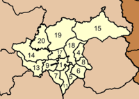
Missing numbers are tambon which now form Na Yong district.
External links
- http://www.mueangtrang.dopatrang.go.th Website of district (Thai only)
Mueang Trang · Kantang · Yan Ta Khao · Palian · Sikao · Huai Yot · Wang Wiset · Na Yong · Ratsada · Hat Samran
Categories:- Amphoe of Trang


Wikimedia Foundation. 2010.