- Mueang Samut Prakan District
-
Mueang Samut Prakan
เมืองสมุทรปราการ— Amphoe — Amphoe location in Samut Prakan Province
Coordinates: 13°36′2″N 100°35′48″E / 13.60056°N 100.59667°ECoordinates: 13°36′2″N 100°35′48″E / 13.60056°N 100.59667°E Country  Thailand
Province Samut Prakan Seat Pak Nam Area – Total 190.5 km2 (73.6 sq mi) Population (2005) – Total 460,141 – Density 2,415/km2 (6,254.8/sq mi) Time zone THA (UTC+7) Postal code 10270 Geocode 1101 Mueang Samut Prakan (Thai: เมืองสมุทรปราการ; IPA: [mɯ̄aŋ sāmùt prāːkāːn]) is the capital district (Amphoe Mueang) of Samut Prakan Province, central Thailand. The district has the highest population of all districts of Thailand.
Contents
Tourist attractions
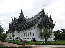 Sangphet Prasat Throne Hall in Mueang Boran
There are now 3 major tourist attractions of the province are located in the capital district.
In Tambon Bang Pu Mai is Mueang Boran or Ancient City, a park that features downscaled replicas of all major historical buildings of Thailand. It was used as a set for some scenes in the film Two Brothers.
There is also the Erawan Museum which is a large sculpture of the 3 headed elephant. Inside is a museum that features 4 pillars depicting the major religions of the world, various theistic themes and sculptures made using pottery.
The other popular tourist draw is the Crocodile Farm in Tambon Tai Ban.
Administration
The district is subdivided into 13 subdistricts (tambon). The city (thesaban nakhon) Samut Prakan covers the whole tambon Pak Nam. There are 5 subdistrict municipalities (thesaban tambon) - Dan Sam Rong covers parts of tambon Samrong Nuea, Samrong Nuea covers further parts of tambon Samron Nuea and parts of Bang Mueang Mai and Thepharak. Bang Mueang covers parts of tambon Bang Mueang, Bang Mueang Mai and Thepharak. Bang Pu covers the whole tambon Bang Pu, Bang Pu Mai, Thai Ban and Thai Ban Mai; Phraek Sa covers parts of tambon Phraek Sa and Phraek Sa Mai. There are further 6 Tambon administrative organizations (TAOs) responsible for the non-municipal areas.
No. Name Thai name Villages Inh.[1] 1. Pak Nam ปากน้ำ - 57,046 2. Samrong Nuea สำโรงเหนือ 10 72,666 3. Bang Mueang บางเมือง 10 54,319 4. Thai Ban ท้ายบ้าน 11 24,652 8. Bang Pu Mai บางปูใหม่ 10 36,842 10. Phraek Sa แพรกษา 8 27,969 11. Bang Prong บางโปรง 4 8,822 12. Bang Pu บางปู 4 7,037 13. Bang Duan บางด้วน 8 8,744 14. Bang Mueang Mai บางเมืองใหม่ 11 49,314 15. Thepharak เทพารักษ์ 9 49,851 16. Thai Ban Mai ท้ายบ้านใหม่ 8 45,269 17. Phraek Sa Mai แพรกษาใหม่ 6 17,610 The missing geocodes in the table are the tambon which were split off at the creation of Amphoe Phra Samut Chedi.
References
- ^ "Population statistics 2008". Department of provincial administration. http://www.dopa.go.th/xstat/p5111_01.html.
External links
- amphoe.com (Thai)
Categories:- Amphoe of Samut Prakan
- Central Thailand geography stubs


Wikimedia Foundation. 2010.