Malian Gulf

Malian Gulf
Map of Greece with the Phthiotis Prefecture highlighted
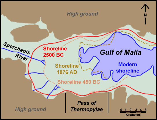
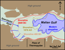
Map of the Malian Gulf shoreline at various times from Antiquity until the present day

The Malian or Maliac Gulf (Greek: Μαλιακός Κόλπος; Latin: Maliacus Sinus) is a gulf of the Aegean Sea in the region of Phthiotis in eastern Central Greece. The gulf is named after the ancient Malians who lived on its shores.

It stretches east to west to a distance of 15 to 22 km, depending on the definition. Due to the constant accretion of silt from the river the Spercheios and smaller streams, the gulf has been shrinking over the centuries and is very shallow, with a maximum depth is 27 m. Thus the ancient strait of Thermopylae, which at the time the famous battle was fought, was delineated by Mount Kallidromo and the Malian Gulf, has now become a broad coastal plain. The only harbour is that of Stylida, which serves the city of Lamia. To its east is the northwesternmost point of the island of Euboea, Cape Lichada.

Coordinates: 38°52′N 22°38′E / 38.867°N 22.633°E / 38.867; 22.633


Wikimedia Foundation. 2010.

Игры ⚽ Нужно решить контрольную?

Look at other dictionaries:

  • North Evian Gulf — The North Evian Gulf (Greek: Βόρειος Ευβοϊκός Κόλπος Voreios Evvoïkos Kolpos ), also the North Evvian Gulf or the North Euboean Gulf is a gulf of the Aegean Sea. It separates the northern part of the island Euboea from the mainland of Greece. The …   Wikipedia

  • North Euboean Gulf — The North Euboean Gulf (Greek: Βόρειος Ευβοϊκός Κόλπος, Voreios Evvoïkos Kolpos) is a gulf of the Aegean Sea. It separates the northern part of the island Euboea from the mainland of Central Greece. The narrow Euripus strait, near Chalcis,… …   Wikipedia

  • Highways in Greece — are generally organized so that the odd numbered highways are of north south alignment and even numbered highways are aligned east west. However there are many exceptions. The designation of some important roads of Greece as national was decided… …   Wikipedia

  • Euboea — For the mythological figure, see Euboea (mythology). For the administrative unit, see Euboea (regional unit). Euboea Εύβοια Chalkis Geography …   Wikipedia

  • Lichada — or Lihada (Greek, Modern: Λιχάδα), older forms: Lichas or Lihas is a community in Euboea, Greece. Its 2001 population was 240 for the village and 1,140 for the community. Lichada is located northwest of Chalkida, west of Istiea and Aidipsos. The… …   Wikipedia

  • Mount Giona — Giona The mountain of Giona as seen from Panourgia, the north face of the mountain Elevation 2,510 m (8,235 ft) …   Wikipedia

  • Kallidromo — Infobox Mountain Name=Kallidromo Photo= Caption= Elevation=convert|1372|m|ft|0 Range= Location=Northern Phokida and Fthiotida prefectures, Greece Coordinates= Type= | Age= Translation= |Language= Pronunciation=Ka•li•dro•moKallidromo or Kalidromo… …   Wikipedia

  • Kantili — Infobox Mountain Name=Kantili Photo= Caption= Elevation=convert|1227|m|ft|0 Range= Location=Northwest central Euboea, Greece Coordinates= Type= | Age= Translation= |Language= Pronunciation=Kant•i•liKantili or Kandili (Greek: Καντήλι) older forms …   Wikipedia

  • Tilethrio — Infobox Mountain Name=Tilethrio Photo= Caption= Elevation=convert|970|m|ft|0 Range= Location=Northwest central Euboea, Greece Coordinates= Type= | Age= Translation= |Language= Pronunciation=Tel•eth•ri•oTilethrio (Greek, Modern: Τηλέθριο,… …   Wikipedia

  • Ephialtes of Trachis — (Greek: Ἐφιάλτης, Ephialtēs; although Herodotus spelled it as Ἐπιάλτης, Epialtes) was the son of Eurydemus of Malis.[1] He betrayed his homeland by showing the Persian forces a path around the allied Greek position at the pass of Thermopylae,… …   Wikipedia

Share the article and excerpts

Direct link
Do a right-click on the link above
and select “Copy Link”