- Dorset Island
-
Dorset Island 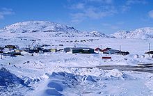
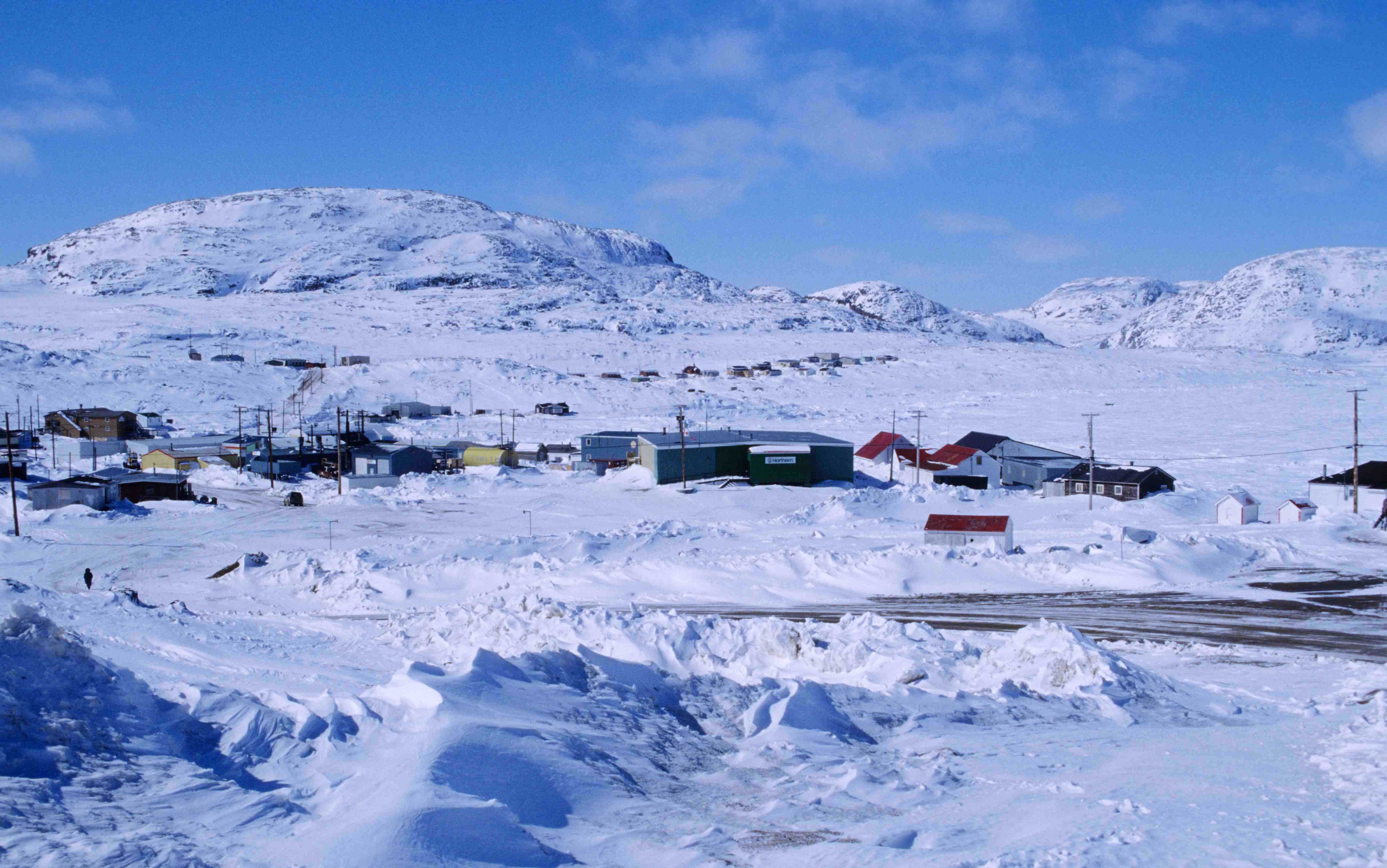
Dorset Island's Kinngait Hill and the hamlet of Cape Dorset, 1997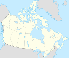
 Location in Canada
Geography Location Hudson Strait Coordinates 64°12′N 76°32′W / 64.20°N 76.53°WCoordinates: 64°12′N 76°32′W / 64.20°N 76.53°W Archipelago Canadian Arctic Archipelago Highest point Cape Dorset, 243 m (797 ft) Country Territory  Nunavut
Region Qikiqtaaluk Demographics Population 1,236[1] (as of 2006 census) Ethnic groups Inuit Dorset Island is one of the Canadian Arctic islands located in Hudson Strait, Nunavut, Canada. It lies off the Foxe Peninsula area of southwestern Baffin Island in the Qikiqtaaluk Region.[2] It is serviced by an airport and a harbour.[3]
The island was named after the statesman Edward Sackville, 4th Earl of Dorset.[4]
Contents
Geography
The island is 4 mi (6.4 km) long and 2 mi (3.2 km) wide, with its highest elevation 220 m (720 ft) above sea level.[5]
On the southern end of Dorset Island, at an elevation of 243 m (797 ft) above sea level, the mountain, Cape Dorset, projects into the Hudson Strait. It is part of the Kingnait Range (Kingnait, in Inuktitut, means "high mountains").[2][5] The cape represents the southern tip of the Foxe Peninsula. On September 24, 1631, Captain Luke Foxe named the landform "Cape Dorset" to honor his benefactor, Lord Chamberlain, Edward Sackville, 4th Earl of Dorset.[4]
Kingnait Hill, at 208 m (682 ft) high, is located on the island's north-west side. The shorter Eegatuak Hill is located 0.7 mi (1.1 km) north of the cape, on its eastern side, rising 99 m (325 ft) above sea level, and exhibiting a distinctive bowl-shape surmounted by a cairn.[3][5]
Mallik Island, directly to the north, is joined to Dorset Island by sand and boulders. A natural harbour exists in the peninsula formed by the southeast side of Mallik Island and the northwest side of Dorset Island with prevailing northwesterly winds at 10 to 15 knots, stronger in September and October. The anchorage may have heavy swell conditions and there is frequest fog during the navigation season of early August through mid-October. Ice break-up is around mid-July, and freeze-up occurs in early November. Winter ice thickness can be up to 1.2 m (3 ft 11 in).[5]
There are several other islands within 10 km, including Okolli Island and Sakkiak Island.[3]
History
In 1913, a trading post was established on the island by the Hudson's Bay Company. A Roman Catholic mission was located on Dorset Island during the period of 1938 to 1960.[6]
The first discovery of the remains of Dorset culture was on Dorset Island.[7] An ancient Paleo-Eskimo people, they flourished in this area for about 2,000 years, during the period of 1000 BC through 1100 AD. Present-day Dorset Islanders, Inuit who descend from the later Thule culture, refer to Dorset culture people as tuniit in their legends.[2]
Community
Across from Mallik Island, on the northern side of Dorset Island is located the Inuit hamlet of Cape Dorset (also named Kingnait). It is approximately 7.2 mi (11.6 km) north of the mountain cape bearing the same name. Because the people of this community are known for their artisanship, including drawing, printmaking, and carving, the community of Cape Dorset is commonly referred to as the "Inuit art capital".[8]
Wildlife
The island and its surrounds are frequented by Arctic wolves, polar bears, and Arctic fox,[9] as well as caribou and Arctic hare. Seals appear regularly, as do beluga whale during their migration through by the island in October and April.[6]
Peregrine falcons, snowy owls, ptarmigan and ducks abound.[6] Ornithologists consider the island's cape a major entry way to the nesting area of the Blue Goose. In 1929, it was the departure point for naturalist Dr. J. Dewey Soper in his quest for locate the Blue Goose's Foxe Basin nest area.[2]
Mallikjuaq Territorial Park spans both Dorset Island and Mallik Island. Notable for its Thule culture, Dorset culture, and Inuit archaeological sites that date back as far as 3,000 years ago, it is reachable by foot from Cape Dorset at low tide, or by boat.[10]
References
- ^ 2006 census
- ^ a b c d "CAPE DORSET: Kingnait". Qikiqtani Inuit Association. qia.ca. http://www.qia.ca/i18n/english/communities/cape_dorset.shtm. Retrieved 2009-02-16.
- ^ a b c "Dorset Island". travelingluck.com. http://travelingluck.com/North+America/Canada/Nunavut/_5941903_Dorset+Island.html#local_map. Retrieved 2009-02-16.
- ^ a b Room, Adrian (1989). Dictionary of World Place Names Derived from British Names. Taylor & Francis. pp. 46. ISBN 0415028116. http://books.google.com/books?id=7JEOAAAAQAAJ&pg=PA46&lpg=PA46&dq=Edward+Sackville+luke+foxe&source=web&ots=v5cpmLh4mH&sig=qzrRYBUvVbS4p8Cdx991tCB5uNY&hl=en&ei=XsqZSbSFD5m0sQPAhbyEAQ&sa=X&oi=book_result&resnum=2&ct=result.
- ^ a b c d "Sector13.HudsonStrait". National Geospatial Intelligence Agency. pollux.nss.nima.mil. pp. 14–15. http://google.com/search?q=cache:XQ4BEJz9NRoJ:pollux.nss.nima.mil/NAV_PUBS/SD/Pub146/146sec13.pdf+Alareak+Island+baffin&hl=en&ct=clnk&cd=3&gl=us&client=firefox-a. Retrieved 2009-02-16.
- ^ a b c "CAPE DORSET". gov.nu.ca. http://www.gov.nu.ca/wpc/capedorset.html. Retrieved 2009-02-16.
- ^ "Cape Dorset (Kingnait) – ‘mountains’". usask.ca. http://scaa.usask.ca/gallery/northern/content?pg=ex13-2. Retrieved 2009-02-16.
- ^ "Cape Dorset News". edu.nu.ca. http://mailhub.edu.nu.ca/~pitseolak/cape_dorset_news.htm. Retrieved 2009-02-16.
- ^ "WILDLIFE SIGHTINGS IN TOWN". edu.nu.ca. http://mailhub.edu.nu.ca/~pitseolak/cape_dorset_news.htm. Retrieved 2009-02-16.
Islands of the Qikiqtaaluk Region Adams · Akpatok · Alfred · Allen · Amherst · Arvalik · Aulitivik · Aulitiving · Baffin · Barth · Beloeil · Bergesen · Bjarnason · Bylot · Curry · Davids · Dexterity · Diana · Edgeworth · Eider · Elder · Emmerson · Fraser · Frechette · Gyrfalcon · Hamilton · Imiqqutailaqtuuq · Kaigosuiyat · Kilian · Lady Franklin · Landslip · Liddon · Lock · Low · Marvin · Nakoaiyet · Nova Zembla · Old Squaw · Ormonde · Otrick · Pandora · Payne · Peter Richards · Pisiktarfik · Plover · Prescott · Prince Leopold · Prince of Wales · Ragged · Round · Russell · Salikuit · Saneruarsuk · Scott · Sillem · Somerset · Spicer · Stephens · Trinity · Vesey Hamilton · Vivian · Ward Hunt · Wollaston · Yeoman · YoungBelcher Islands Islands of Cumberland Sound Akulagok · Anarnittuq · Aupaluktok · Aupaluktut · Beacon · Blacklead · Clear Passage · Drum · Ekallulik · Iglunga · Imigen · Ivisa · Kaigosuit · Kangigutsak · Kekertelung · Kekertelung · Kekerten · Kekertukdjuak · Kudjak · Maktaktujanak · Miliakdjuin · Moodie · Nimigen · Nunatak · Nuvujen · Opingivik · Sanigut · Saunik · Shakshukowshee · Shakshukuk · Tesseralik · Tuapait · Ugpitimik · Utsusivik · WarehamIslands of Davis Strait Akuglek · Alikdjuak · Angijak · Durban · Idjuniving · Kekertaluk · Kekertuk · Kekerturnak · Manitung · Monumental · Nedlukseak · Nudlung · Nunatsiaq · Nuvuktik · Padloping · Pilektuak · Qaqaluit · Rock · SatigsunIslands of Foxe Basin Air Force · Bird · Bray · Deer · Foley · Igloolik · Jens Munk · Koch · Neerlonakto · North Tweedsmuir · Prince Charles · Rowley · South Tweedsmuir · Tern · White · WinterIslands of Frobisher Bay Algerine · Alligator · Anchorage · Aubrey · Augustus · Bear · Beveridge · Bishop · Brigus · Brook · Bruce · Cairn · Camp · Carter · Chase · Coffin · Crimmins · Crowell · Culbertson · Daniel · Dog · Eden · Emerick · Falk · Faris · Field · Fletcher · Frobisher's Farthest · Gabriel · Gardiner · Gay · Gross · Halford · Hantzsch · Harper · Hill · Jenvey · Kudlago · Kungo · Lefferts · Leopold · Loks Land · Long · Low · Luella · Mair · Mark · Mary · McAllister · McBride · McLaren · McLean · Metela · Mitchell · Monument · Nest · Nouyarn · Ogden · Pan · Peak · Pichit · Pike · Pink Lady · Pope · Potter · Precipice · Ptarmigan · Pugh · Qarsau · Quadrifid · Redan · Resor · Sale · Scalene · Sliver · Smith · Sybil · Thompson · WhiskukunIslands of the Gulf of Boothia Islands of Hudson Bay Islands of Hudson Strait Alareak · Aulassivik · Avingasittuit Siqinirsipangat · Beacon · Big · Black Bluff · Bush · Button · Charles · Clark · Dolphin · Dorset · Edgell · Emma · Erhardt · Forder · Glasgow · Glencoe · Goodwin · Gudmusson · Hector · High Bluff · Holdridge · Ijjurittiak · Ivisaat · Juet · King · Lacy · Lavoie · Lawson · Leading · Lee · Lower Savage · MacColl · Mallik · Middle Savage · Mill · Niels · Nottingham · Nunajuak · Nuvursiit · Nuvursirpaaraaluk · Observation · Okolli · Point · Poodlatee · Rabbit · Resolution · Sakkiak · Salisbury · Sheer · Strathcona · Uugalautiit · WishartIslands of James Bay Akimiski · Bear · Big · Cape Hope · Carey · Charlton · Grey Goose · Gull · Jacob · North Twin · Paint Hills · Solomons Temple · South Twin · Spencer · Strutton · Sunday · Trodely · Twin · Walter · WestonIslands of the Labrador Sea Brevoort · Cape Chidley · Christopher Hall · Hozier · Hudson · Ilikok · Jackson · Killiniq · Knight · Leybourne · Little Hall · Muingmak · RogersQueen Elizabeth Islands Alexander · Baillie-Hamilton · Bathurst · Beechey · Berkeley • Borden · Brock · Browne · Buckingham · Byam Martin · Cameron · Cheyne · Coburg · Cocked Hat · Cornwall · Cornwallis · Crescent · Des Voeux · Devon · Dundas · Edmund Walker · Eglinton · Ekins · Ellesmere · Emerald · Exmouth · Fairholme · Findlay Group · Garrett · Graham · Griffith · Grosvenor · Hansdisputed · Helena · Houston Stewart · Hoved · Hyde Parker · John Barrow · Little Cornwallis · Lougheed · Lowther · Mackenzie King · Marc · Margaret · Massey · Melville · Nookap · Norman Lockyer · North Kent · Patterson · Philpots · Pim · Pioneer · Prince Patrick · Princess Royal · Seymour · Skraeling · Spit · Stupart · Table · Thor · Truro · VanierSverdrup Islands Amund Ringnes · Axel Heiberg · Ellef Ringnes · Fay · Gretha · Haig-Thomas · Hat · King Christian · Meighen · Stor · UlvingenSee also Islands of the Kitikmeot Region, Islands of the Kivalliq Region. Categories:- Baffin Island
- Canadian Arctic Archipelago
- Islands of Hudson Strait
- Islands of Qikiqtaaluk Region

Wikimedia Foundation. 2010.