De Hoef, Utrecht

De Hoef, Utrecht
De Hoef
Coordinates: 52°12′35″N 4°48′53″E / 52.20972°N 4.81472°E / 52.20972; 4.81472Coordinates: 52°12′35″N 4°48′53″E / 52.20972°N 4.81472°E / 52.20972; 4.81472
Country Netherlands
Province Utrecht
Municipality De Ronde Venen
Population (2007) 913
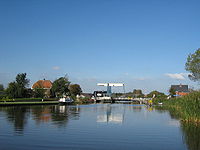
Bridge across the Kromme Mijdrecht

De Hoef (52°12′N 4°49′E / 52.2°N 4.817°E / 52.2; 4.817) is a village in the Dutch province of Utrecht. It is a part of the municipality of De Ronde Venen, and lies about 13 km northeast of Alphen aan den Rijn.

On 1 January 2005, it had 928 inhabitants (500 male, 428 female)[1].

Flowing through the village is a meandering river called "de Kromme Mijdrecht", the width of which varies between about 8 and 35 metres. On average, it is used by about two freight ships per day, but in summer the river is full of pleasure boats.

Notable residents

De Hoef is the birthplace of Nicolien Sauerbreij (born 1979) olympic champion snowboard

References


Wikimedia Foundation. 2010.

Игры ⚽ Нужна курсовая?

Look at other dictionaries:

  • De Hoef (Utrecht) — De Hoef (coord|52|12|N|4|49|E|type:city(166)) is a village in the Dutch province of Utrecht. It is a part of the municipality of De Ronde Venen, and lies about 13 km northeast of Alphen aan den Rijn.On January 1 2005, it had 928 inhabitants (500… …   Wikipedia

  • De Hoef — is the name of several locations in the Netherlands: De Hoef, Utrecht De Hoef, Eersel, in North Brabant De Hoef, Reusel De Mierden, in North Brabant De Hoef, Werkendam, in North Brabant De Hoef, Mill en Sint Hubert, in North Brabant De Hoef,… …   Wikipedia

  • De Hoef — 52°12′35″N 4°48′53″E / 52.20972, 4.81472 …   Wikipédia en Français

  • De Ronde Venen —   Municipality   Vinkeveen …   Wikipedia

  • List of places in the Netherlands — This is an alphabetical list of places (cities, towns, villages) in the Netherlands. Lists per province can be found at:* List of towns in Groningen * List of towns in Friesland * List of towns in Drente * List of towns in Overijssel * List of… …   Wikipedia

  • De Ronde Venen — Gemeinde De Ronde Venen Flagge Wappen Provinz Utrecht …   Deutsch Wikipedia

  • De Ronde Venen — Héraldique …   Wikipédia en Français

  • Mijdrecht — Coordinates: 52°12′26″N 4°51′34″E /  …   Wikipedia

  • Nicolien Sauerbreij — Personal information Nationality Dutch Born July 31, 1979 (1979 07 31) (age 32) …   Wikipedia

  • Landelijke Fietsroutes — Wegweiser LF3a Die Landelijke Fietsroutes (kurz: LF Routen) sind ein landesweites Radwegenetz in den Niederlanden. Die Wege sind in beiden Richtungen ausgeschildert und tragen je nach Richtung einen Buchstabenzusatz (LF1a, LF1b, etc.). Im… …   Deutsch Wikipedia

Share the article and excerpts

Direct link
Do a right-click on the link above
and select “Copy Link”