- D503 road (Croatia)
-
D503 state road
Route information Length: 16.2 km (10.1 mi) Major junctions From:  D27 in Šopot
 A1 in Benkovac interchange
To: Biograd na Moru ferry port Location Counties: Zadar Major cities: Biograd na Moru Highway system State roads in Croatia
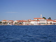 Biograd na Moru, at the southern terminus of D503
D503 is a state road in the northern Dalmatia region of Croatia that provides access from the A1 motorway's Benkovac interchange to the D8 state road, facilitating access from A1 motorway to Biograd na Moru and surrounding seaside resorts.[1] The road is 16.2 km (10.1 mi) long.[2]
The southern terminus of the road is located in Biograd na Moru ferry port, from where Jadrolinija ferries fly to Tkon island.[3][4]
At its northern terminus, the road connects to D27 state road which serves as a parallel road to the A1 motorway, connecting to Gračac (to the north) facilitating a bypass of Maslenica bridges in case of strong winds preventing use of both of the bridges.[5]
The road, as well as all other state roads in Croatia, is managed and maintained by Hrvatske ceste, a state-owned company.[6]
Contents
Traffic volume
Traffic is regularly counted and reported by Hrvatske ceste, operator of the road.[7] Substantial variations between annual (AADT) and summer (ASDT) traffic volumes are attributed to the fact that the road connects a number of summer resorts to Croatian motorway network.
D503 traffic volume Road Counting site AADT ASDT Notes  D503
D5034917 Kakma 3,299 5,807 Adjacent to Kakma. Road junctions
D503 major junctions/populated areas Type Slip roads/Notes 
Zapužane
D27 to Gračac (to the north) and to A1 motorway Benkovac interchange (to the south).
The northern terminus of the road. Northbound D503 traffic defaults to northbound D27.Polača
Ž6047 to Tinj.Kakma
Ž6042 to Galovac and Vrana.Biograd na Moru
 D8 to Sveti Filip i Jakov to the north, and Pakoštane to the south.
Biograd na Moru ferry port
Ferry access to Tkon, Pašman island (D110).
The southern terminus of the road.See also
- State roads in Croatia
- Hrvatske ceste
- Jadrolinija
Sources
- ^ "Regulation on motorway markings, chainage, interchange/exit/rest area numbers and names" (in Croatian). Narodne novine. May 6, 2003. http://narodne-novine.nn.hr/clanci/sluzbeni/305463.html.
- ^ "Decision on categorization of public roads as state roads, county roads and local roads" (in Croatian). Narodne novine. February 17, 2010. http://narodne-novine.nn.hr/clanci/sluzbeni/2010_02_17_410.html.
- ^ "Jadrolinija ferry service" (in English). May 11, 2010. http://www.jadrolinija.hr/default.aspx?lang=2.
- ^ "Sailing schedule for 2010" (in Croatian). May 18, 2010. http://www.agencija-zolpp.hr/Brodskelinije/tabid/1267/Default.aspx.
- ^ "Snow and wind hinder traffic in entire Croatia" (in Croatian). Slobodna Dalmacija. March 10, 2010. http://web2.slobodnadalmacija.hr/Hrvatska/tabid/66/articleType/ArticleView/articleId/94733/Default.aspx.
- ^ "Public Roads Act" (in Croatian). Narodne novine. December 14, 2004. http://narodne-novine.nn.hr/clanci/sluzbeni/2004_12_180_3130.html.
- ^ "Traffic counting on the roadways of Croatia in 2009 - digest" (in English). Hrvatske ceste. May 1, 2010. http://www.hrvatske-ceste.hr/WEB%20-%20Legislativa/brojenje-prometa/CroDig2009.pdf.
Categories:- State roads in Croatia
- Zadar County


Wikimedia Foundation. 2010.