- Cottonwood Air Force Station
-
Cottonwood Air Force Station 
Part of Air Defense Command (ADC) Type Air Force Station Coordinates 46°04′01″N 116°27′51″W / 46.06694°N 116.46417°W Location code ADC ID: SM-150 Built 1958 In use 1958-1965 Current
conditionclosed Controlled by  United States Air Force
Garrison 822d Aircraft Control and Warning Squadron 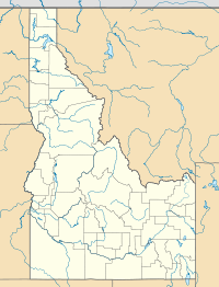
 Cottonwood AFSLocation of Cottonwood AFS, Idaho
 Emblem of the 822d Radar Squadron
Cottonwood Air Force Station is a closed United States Air Force General Surveillance Radar station. The radar site was located at the summit of Cottonwood Butte, 5.7 miles (9.2 km) west-northwest of Cottonwood, Idaho. It was closed in 1965.
Cottonwood Peak Air Force Station was initially part of Phase II of the Air Defense Command Mobile Radar program. The Air Force approved this expansion of the Mobile Radar program on October 23, 1952. Radars in this network were designated “SM.”
Contents
History
The station became operational on 1 July 1958 when the 822d Aircraft Control and Warning Squadron was assigned to the new station by the 9th Air Division. The station consisted of 66 buildings, including operation and administrative facilities, 3 dormitories, 27 family housing units, 3 radar domes, and the normal support facilities/utilities. The site was divided into 3 general areas: a family housing annex, cantonment area, and an operations area. The 822d AC&W operated used AN/MPS-7, AN/MPS-14, and AN/FPS-6 radars, and initially the station functioned as a Ground-Control Intercept (GCI) and warning station. As a GCI station, the squadron's role was to guide interceptor aircraft toward unidentified intruders picked up on the unit's radar scopes.
During 1960 Cottonwood AFS joined the Semi Automatic Ground Environment (SAGE) system, feeding data to DC-07 at Larson AFB, Washington. After joining, the squadron was re-designated as the 822d Radar Squadron (SAGE) on 1 September 1960. The radar squadron provided information 24/7 the SAGE Direction Center where it was analyzed to determine range, direction altitude speed and whether or not aircraft were friendly or hostile. In 1962 the 822d began operating an AN/FPS-24 search radar and an additional AN/FPS-6B radar, as the AN/MPS-7 and AN/MPS-14 units were retired. In 1964 the AN/FPS-6B was upgraded to an AN/FPS-90 and Cottonwood AFS was shifted to feeding data to the SAGE Data center DC-12 at McChord AFB.
In addition to the main facility, Cottonwood operated an AN/FPS-14 Gap Filler site:
- Waha, ID (SM-150A) 46°17′30″N 116°53′01″W / 46.29167°N 116.88361°W
A catastrophic bearing failure in the AN/FPS-24 antenna pedestal led to an early shutdown of the station and the inactivation of the 822nd Radar Squadron on 25 June 1965 (only two or three years after the AN/FPS-24 radome was installed over the antenna) as part of fiscal year 1965 cutbacks.
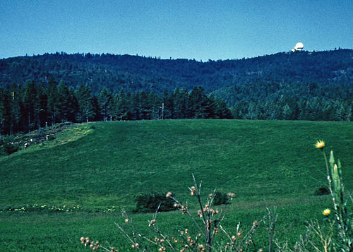 Cottonwood AFS, circa 1964, with large FPS-24 radome dwarfing FPS-6 radome alongside.
The Cantonment Area was used from 1965 to 1972 by the Office of Economic Opportunity as a Job Corps Center. The State of Idaho Dept. of Corrections acquired the property in 1972, and has occupied the site ever since as North Idaho Correctional Institution. This is a program-specific prison designed for male offenders sentenced to a retained jurisdiction commitment by the court. It provides a sentencing alternative for the courts to target those offenders who might, after a period of programming and evaluation, be viable candidates for probation rather than incarceration.
Today most of the radar site is torn down. The AN/FPS-24 tower still stands but little else, as only building foundations and deteriorated streets remain.
Air Force units and assignments
Units:
- 822d Aircraft Control and Warning Squadron, Assigned 1 July 1958
-
- Activated by 9th Air Division at Geiger Field, Washington, 1 February 1957
- Re-designated 822d Radar Squadron (SAGE), 1 September 1960
- Discontinued on 25 June 1965
Assignments:
- 9th Air Division, 1 July 1958
- 25th Air Division, 15 August 1958
- 4700th Air Defense Wing, 1 September 1958
- Spokane Air Defense Sector, 15 March 1960
- Seattle Air Defense Sector, 1 June 1963-25 June 1965
See also
- List of USAF Aerospace Defense Command General Surveillance Radar Stations
References
 This article incorporates public domain material from websites or documents of the Air Force Historical Research Agency.
- A Handbook of Aerospace Defense Organization 1946 - 1980, by Lloyd H. Cornett and Mildred W. Johnson, Office of History, Aerospace Defense Center, Peterson Air Force Base, Colorado
- Winkler, David F. (1997), Searching the skies: the legacy of the United States Cold War defense radar program. Prepared for United States Air Force Headquarters Air Combat Command.
- Information for Cottonwood AFS, ID
External links
Bases CONUSAdair · Beale · Bong (unbuilt) · Charleston · Davis-Monthan · Dobbins · Dover · Dow · Duluth · England · Ent · Ethan Allen · Fairfax · Fort Lee · Geiger · George · Glasgow · Grand Forks · Grenier · Griffiss · Gunter · Hamilton · Hancock · Homestead · Hurlburt · Imeson · K.I. Sawyer · Kincheloe · Kingsley · Kirtland · Larson · Luke · March · Malmstrom · McCoy · McChord · McClellan · McGhee Tyson · McGuire · Minneapolis-St. Paul · Minot · Mitchel · New Castle · Niagara Falls · Norton · O'Hare · Oklahoma City · Otis · Oxnard · Paine · Perrin · Peterson · Pittsburgh · Pope · Portland · Presque Isle · Richards-Gebaur · Selfridge · Seymour Johnson · Sioux City · Snelling · Stead · Stewart · Suffolk County · Tinker · Travis · Truax · Tyndall · Vandenburg · Webb · Westover · Willow Run · Wright-Patterson · Wurtsmith · Youngstown
OverseasErnest Harmon · Frobisher Bay · Goose Bay · Keflavik · Pepperrell · Thule · Topsham

Stations CONUSAlmaden · Charleston · Clear · Cross City · Benton · Empire · Mill Valley · Montauk · Mount Hebo · North Truro · Point Arena · Rye · Thomasville · Watertown
OverseasAlbrook
Air
Defense
unitsForcesAir
DivisionsSectorsAlbuquerque · Bangor · Boston · Chicago · Detroit · Duluth · Goose · Grand Forks · Great Falls · Iceland · Kansas City · Los Angeles · Minot · Montgomery · New York · Oklahoma City · Phoenix · Portland · Reno · Sault Sainte Marie · San Francisco · Seattle · Sioux City · Spokane · Stewart · Syracuse · Washington
WingsGroups1st · 4th · 10th · 14th · 15th · 23rd · 32nd · 33rd · 50th · 52nd · 53rd · 54th · 56th · 57th · 73rd · 78th · 79th · 81st · 82nd · 84th · 325th · 326th · 327th · 328th · 329th · 337th · 355th · 408th · 412th · 414th · 473rd · 475th · 476th · 478th · 500th · 501st · 502d · 503d · 507th · 514th · 515th · 516th · 517th · 518th · 519th · 520th · 521st · 525th · 527th · 528th · 529th · 530th · 533d · 534th · 564th · 566th · 567th · 568th · 575th · 678th · 701st · 4676th · 4700th · 4721st · 4722d · 4727th · 4728th · 4729th · 4730th · 4731st · 4732d · 4733d · 4734th · 4735th · 4756th
SquadronsAerospace Defense Command Fighter Squadrons · Aircraft Control and Warning Squadrons
Major
weapon
systemsElectronicFightersMissiles1 · 2 · 3 · 4 · 5
ShipsGuardian · Interceptor · Interdictor · Interpreter · Investigator · Locator · Lookout · Outpost · Pickett · Protector · Scanner · Searcher · Skywatcher · Tracer · Watchman · Vigil
Miscellaneous Air Defense Command Emblem Gallery (On Wikimedia Commons) · General Surveillance Radar StationsCategories:- SAGE sites
- Radar stations of the United States Air Force
- Aerospace Defense Command
- Buildings and structures in Idaho County, Idaho
- Closed facilities of the United States Air Force
- Military facilities in Idaho


Wikimedia Foundation. 2010.