- Cleveland railway line
-
Cleveland line 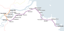
Website queenslandrail.com.au Technical Line length 0 km (0 mi) Track length 37.3 km (23.2 mi) Track gauge 1,067 mm (3 ft 6 in) Cape gauge Operating speed 0 km/h (0 mph) The Cleveland railway line is a suburban railway line extending 24.2 km (15.0 mi) east-southeast from Brisbane (37.3 km from Central station by rail), the state capital of Queensland, Australia. It is part of the QR Citytrain network.
Contents
History
For more details on this topic, see Rail transport in Queensland.The railway was opened to Manly in 1888 and extended to Cleveland in 1890. A further extension to Redland Bay and Mount Cotton was surveyed in 1889 but never constructed.[1]
The duplication from Park Road to Murarrie was opened on 17 June 1912.[2]
In 1960, the line from Lota to Cleveland stations was closed.[3]
The line from Lota to Cleveland was rebuilt, and reopened on a new alignment to Thorneside in 1982 and Cleveland in 1987.
Line guide and services
Most services stop at all stations to Bowen Hills railway station. The typical travel time between Cleveland and Brisbane City is approximately 56 minutes (to Central). During weekday peak times, a few services may skip some stations between Park Road and Manly stations, for faster travel times for commuters working in the Brisbane central business district. In addition, an afternoon service on school days only operates express between Cleveland and Buranda stations, stopping only at Thorneside, Manly and Lota.
Cleveland line services typically continue as Doomben line services.
Passengers for/from the Beenleigh and Tennyson lines change at Park Road, Gold Coast line at South Bank, Ipswich and Rosewood lines at Roma Street, and all other lines at Central.
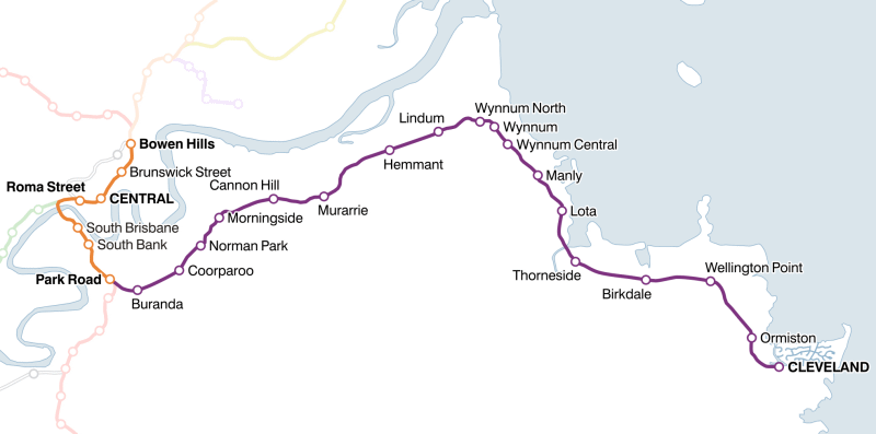
Cleveland railway line, Brisbane
showing distance from Central, ticket zone, and connecting or nearby bus services

Airtrain, Caboolture, Doomben, Ferny Grove, Nambour and Gympie North, Shorncliffe lines 
2.7 km Bowen Hills (1) 301, 310, 315, 320, 393 

Exhibition line 
1.3 km Fortitude Valley (1) See Fortitude Valley railway station 
0.0 km CENTRAL (1) See Adelaide Street Bus Mall 
0.8 km Roma Street (1) See Roma Street railway station 
Exhibition line 
Ipswich, Rosewood lines 
Pacific Motorway 
Brisbane River 2.6 km South Brisbane (1) See Cultural Centre Busway Station 3.6 km South Bank (1) See South Bank Busway Station 
Gloucester Street 5.1 km Park Road (1/2) See Boggo Road busway station 


Port of Brisbane line (from Acacia Ridge) standard gauge flyover 
Beenleigh, Gold Coast, Tennyson lines 
Pacific Motorway 
6.2 km Buranda (2) See Buranda busway station 
Norman Creek 7.9 km Coorparoo (2) 184, 185 9.1 km Norman Park (2) 212, 214, 215, 220 10.5 km Morningside (2) 222, 235, 236 12.6 km Cannon Hill (2/3) 232 14.3 km Murarrie (3) 598, 599 Gateway Motorway 

Incitec Pivot freight branch Doboy Bulimba (Doboy) Creek 
17.4 km Hemmant (3) 19.2 km Lindum (3) 223, 224 
Port of Brisbane standard gauge freight line 20.8 km Wynnum North (3/4) 223, 224 21.7 km Wynnum (4) 220, 221, 223, 224 22.4 km Wynnum Central (4) 220, 221, 223, 224, 225, 240, 241 24.1 km Manly (4) 223, 224 25.9 km Lota (4/5) 223, 224 Tingalpa Creek 27.8 km Thorneside (5) 253 30.6 km Birkdale (5) 253, 254, 255 32.9 km Wellington Point (5/6) 255 35.6 km Ormiston (6) 252, 256, 257 
37.3 km CLEVELAND (6) 250, 252, 255, 256, 258, 272, 274, 275 References
- ^ Plans and sections of various Queensland Railway Lines. (AA21 - YB24). Cleveland to Redland Bay and Mt. Cotton. RB 21 SHEET 2. 1889. Series 4611, Item 805633. Queensland State Archives.
- ^ "The Cleveland Railway.". The Brisbane Courier: p. 4. 1912-06-18. http://nla.gov.au/nla.news-article19748608. Retrieved 2011-10-18.
- ^ Ludlow, Peter (26 March 2007). "Moreton Bay Database". http://www.users.bigpond.net.au/pludlow/Database.htm. Retrieved 2007-12-14.
External links
Queensland Rail's city rail lines Northern Southern Inner city Categories:- Brisbane railway lines
- Public transport in Brisbane
Wikimedia Foundation. 2010.