- Administrative divisions of Armenia
-
Subdivisions of Armenia 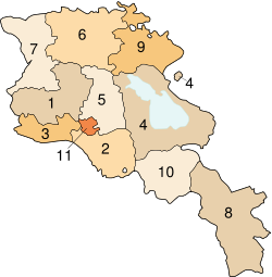
Legend Map ref. Administrative
divisionProvincial
capital1 Aragatsotn Ashtarak 2 Ararat Artashat 3 Armavir Armavir 4 Gegharkunik Gavar 5 Kotayk Hrazdan 6 Lori Vanadzor 7 Shirak Gyumri 8 Syunik Kapan 9 Tavush Ijevan 10 Vayots Dzor Yeghegnadzor 11 Yerevan – Part of the series on
Armenia
Հայաստան

Administrative divisions
Aragatsotn · Ararat · Armavir
Gegharkunik · Kotayk · Lori · Shirak
Syunik · Tavush · Vayots Dzor
Yerevan (city with special status)Armenia is subdivided into eleven administrative divisions. Of these, ten are provinces, known as marzer (մարզեր) or in the singular form marz (մարզ) in Armenian.
Yerevan is treated separately and granted special administrative status as the country's capital. The chief executive in each of 10 marzes is the marzpet, appointed by the government of Armenia. In Yerevan, the chief executive is the mayor, appointed by the president.
Contents
Provinces
The following is a list of the provinces with population, area, and density information. Figures are from the National Statistical Service of the Republic of Armenia. Note that the area of the Gegharkunik Province includes Lake Sevan which covers 1,278 square kilometres (493 sq mi) of its territory. To sort the information, use the arrow devices in the table headings.
Province Population % Density Yerevan 1,091,235 36.3% 5,196.4 /km2 (13,459 /sq mi) Shirak 257,242 8.6% 96.0 /km2 (249 /sq mi) Armavir 255,861 8.5% 206.2 /km2 (534 /sq mi) Lori 253,351 8.4% 66.8 /km2 (173 /sq mi) Ararat 252,665 8.4% 126.1 /km2 (327 /sq mi) Kotayk 241,337 8.0% 114.9 /km2 (298 /sq mi) Gegharkunik 215,371 7.2% 58.9 /km2 (153 /sq mi) Syunik 134,061 4.5% 29.8 /km2 (77 /sq mi) Aragatsotn 126,278 4.2% 45.8 /km2 (119 /sq mi) Tavush 121,963 4.1% 39.1 /km2 (101 /sq mi) Vayots Dzor 53,230 1.8% 22.1 /km2 (57 /sq mi) Communities (hamaynkner)
Main article: List of municipalities in ArmeniaWithin each province are communities (hamaynkner, singular hamaynk). Each community is self-governing and consists of one or more settlements (bnakavayrer, singular bnakavayr). Settlements are classified as either towns (kaghakner, singular kaghak) or villages (gyugher, singular gyugh). As of 2007, Armenia includes 915 communities, of which 49 are considered urban and 866 are considered rural. The capital, Yerevan, also has the status of a community.[1] Additionally, Yerevan is divided into twelve semi-autonomous districts.
See also
- ISO 3166-2:AM
References
- ^ "Regional Administration Bodies". The Government of the Republic of Armenia. Archived from the original on 2008-04-20. http://web.archive.org/web/20080420205327/http://www.gov.am/enversion/regional_7/regional.htm. Retrieved 2008-09-11.
External links
 Armenia topics
History (timeline) EarlyOrigins · Name · Kura-Araxes culture · Hayk · Hayasa-Azzi · Mitanni · Nairi · Kingdom of Urartu · Orontid dynasty · Kingdom of Armenia · Roman Armenia · Byzantine Armenia · Bagratuni Armenia · Armenian Kingdom of CiliciaMiddleModernBy topicGovernment and
politicsConstitution · President · Prime Minister · National Assembly · Political parties · Elections · Foreign relations · Corruption · Human rights · LGBT rights · Relations with the European Union · more on government / politicsEconomy Armenian dram · Central Bank · List of companies · Armex · Agriculture · Industry · Communications · Transport · Energy · Mining · Waste management · International rankingsAdministrative
divisionsArmed Forces Geography Demographics Religion Culture Symbols Administrative divisions of Armenia Marzer (մարզեր) Aragatsotn · Ararat · Armavir · Gegharkunik · Kotayk · Lori · Shirak · Syunik · Tavush · Vayots Dzor
City with special status Yerevan (capital)First-level administrative divisions in Europe Sovereign
statesAlbania · Andorra · Armenia2 · Austria · Azerbaijan3 · Belarus · Belgium · Bosnia and Herzegovina · Bulgaria · Croatia · Cyprus2 · Czech Republic · Denmark · Estonia · Finland · France1 · Georgia3 · Germany · Greece · Hungary · Iceland · Ireland · Italy · Kazakhstan2 · Latvia · Liechtenstein · Lithuania · Luxembourg · Republic of Macedonia · Malta · Moldova · Monaco · Montenegro · Netherlands · Norway · Poland · Portugal · Romania · Russia1 · San Marino · Serbia · Slovakia · Slovenia · Spain · Sweden · Switzerland · Turkey1 · Ukraine · United Kingdom
States with limited
recognitionAbkhazia3 · Kosovo · Northern Cyprus2 · South Ossetia3
1 Has part of its territory outside Europe. 2 Considered European for cultural, political and historical reasons but is geographically in West Asia. 3 Partially or entirely in Asia, depending on the definition of the border.Table of administrative country subdivisions by country Articles on first-level administrative divisions of Asian countries Afghanistan · Armenia · Azerbaijan1 · Bahrain · Bangladesh · Bhutan · Brunei · Burma · Cambodia · People's Republic of China · Cyprus · Egypt1 · Georgia1 · India · Indonesia1 · Iran · Iraq · Israel · Japan · Jordan · Kazakhstan1 · North Korea · South Korea · Kuwait · Kyrgyzstan · Laos · Lebanon · Malaysia · Maldives · Mongolia · Nepal · Oman · Pakistan · Palestine · Philippines · Qatar · Russia1 · Saudi Arabia · Singapore · Sri Lanka · Syria · Republic of China (Taiwan) · Tajikistan · Thailand · Timor-Leste (East Timor)1 · Turkey1 · Turkmenistan · United Arab Emirates · Uzbekistan · Vietnam · Yemen1
1 Country spanning more than one continent (transcontinental country).Categories:- Subdivisions of Armenia
- Lists of country subdivisions
- Country subdivisions of Asia
- Country subdivisions of Europe
- Armenia-related lists


Wikimedia Foundation. 2010.