- Mont Ventoux
-
Mont Ventoux 
South side of the summit of Mont VentouxElevation 1,912 m (6,273 ft) Prominence 1,148 m (3,766 ft) [1] Location Vaucluse, France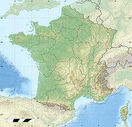
 Mont Ventoux
Range periphery of the Alps Coordinates 44°10′28″N 5°16′44″E / 44.17444°N 5.27889°ECoordinates: 44°10′28″N 5°16′44″E / 44.17444°N 5.27889°E Climbing First ascent Prior to Petrarch; probably ancient Easiest route Hike Col du Mont Ventoux 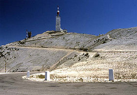
North side of the summit of Mont VentouxElevation 1,912 m (6,273 ft) Traversed by road Location col de Mont Ventoux col de Mont Ventoux
Location  France
Range Free-standing on the western periphery of the Alps Coordinates 44°10′28″N 5°16′44″E / 44.17444°N 5.27889°ECoordinates: 44°10′28″N 5°16′44″E / 44.17444°N 5.27889°E Mont Ventoux (Ventour in Provençal) is a mountain in the Provence region of southern France, located some 20 km northeast of Carpentras, Vaucluse. On the north side, the mountain borders the Drôme département. It is the largest mountain in the region and has been nicknamed the "Giant of Provence", or "The Bald Mountain". It has gained fame through its use in the Tour de France cycling race.
As the name might suggest (venteux means windy in French), it can get windy at the summit, especially with the mistral; wind speeds as high as 320 km/h (200 mph) have been recorded. The wind blows at 90+ km/h (56+ mph) 240 days a year. The road over the mountain is often closed due to high winds. Especially the "col de tempêtes" ("storm pass") just before the summit, which is known for its strong winds. The real origins of the name are thought to trace back to the 1st or 2nd century AD, when it was named 'Vintur' after a Gaulish god of the summits, or 'Ven-Top', meaning "snowy peak" in the ancient Gallic language. In the 10th century, the names Mons Ventosus and Mons Ventorius appear.
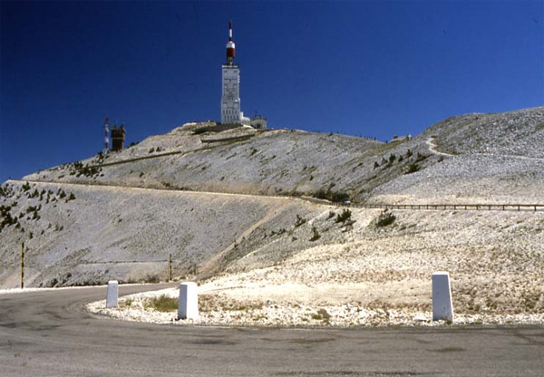
Mont Ventoux, although geologically part of the Alps, is often considered to be separate from them, due to the lack of mountains of a similar height nearby. It stands alone to the north of the Luberon range, separated by the Monts de Vaucluse, and just to the east of the Dentelles de Montmirail, its foothills. The top of the mountain is bare limestone without vegetation or trees, which makes the mountain's barren peak appear from a distance to be snow-capped all year round (its snow cover actually lasts from December to April). Its isolated position overlooking the valley of the Rhône ensures that it dominates the entire region and can be seen from many miles away on a clear day. The view from the top is correspondingly superb.
Contents
History
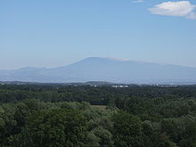 Mont Ventoux as seen from Avignon 30 miles away
Jean Buridan climbed the mountain early in the fourteenth century; Petrarch (accompanied by his brother) repeated the feat on April 26, 1336,[2] and claimed to have been the first to climb the mountain since antiquity, which has been widely repeated since.[3]
The 15th century saw the construction of a chapel on the top, dedicated to the Holy Cross.
In 1882, a meteorological station was constructed on the summit, though it is no longer in use. This observatory was planned in 1879 along with a carriage road for access.[4] In the 1960s a 50m-high telecommunications mast was built.
Flora and fauna
 View of Mont Ventoux from Mirabel-aux-Baronnies
Originally forested, Mont Ventoux was systematically stripped of trees from the 12th century onwards to serve the demands of the shipbuilders of the naval port of Toulon. Some areas have been reforested since 1860 with a variety of hardwood trees (such as holm oaks and beeches) as well as coniferous species, such as Atlas cedars and larches. A little higher, junipers are common.
The mountain comprises the species boundary or ecotone between the flora and fauna of northern and southern France. Some species, including various types of spiders and butterflies, are unique to Mont Ventoux. It is a good place to spot the Short-toed Eagle (Circaetus gallicus).
Its biological distinctiveness was recognised by UNESCO in 1990 when the Réserve de Biosphère du Mont Ventoux was created, protecting an area of 810 square kilometres (200,150 acres) on and around the mountain.
Road cycling
For road bicycle racing enthusiasts, the mountain can be climbed by three routes.
- South from Bédoin: 1617 m over 21,8 km. This is the most famous and difficult ascent. The road to the summit has an average gradient of 7.43%. Until Saint-Estève, the climb is easy: 3.9% over 5,8 km, but the 16 remaining kilometres have an average gradient of 8.9%. The last kilometres may have strong, violent winds. The ride takes 1h30m-2h30m for trained amateur riders. Professional riders take 1h-1h15 min. The fastest time so far recorded has been that of Iban Mayo in the individual climbing time trial of the 2004 Dauphiné Libéré: 55' 51". The time was measured from Bédoin for the first time in the 1958 Tour de France, in which Charly Gaul was the fastest at 1h 2' 9".
- Northwest from Malaucène: 1570 m over 21,5 km. About equal in difficulty as the Bédoin ascent, better sheltered against the wind.
- East from Sault: 1210 m over 26 km. The easiest route. After Chalet Reynard (where the "lunar landscape" of the summit starts), the climb is the same as the Bédoin ascent. Average gradient of 4.4%.
Every year there are amateur races to climb the mountain as quickly and often as possible in 24 hours, the Ventoux Masterseries and "Les Cinglés du Mont Ventoux". On May 16, 2006, Jean-Pascal Roux from Bédoin broke the record of climbs in 24 hours, with eleven climbs, all of them from Bédoin.[5]
Tour de France
File:Provence ventoux simpson1.JPGMemorial to Tom Simpson on Mont VentouxMont Ventoux has become legendary as the scene of one of the most gruelling climbs in the Tour de France bicycle race, which has ascended the mountain fourteen times since 1951. The followed trail mostly passes through Bédoin. Its fame as a scene of great Tour dramas has made it a magnet for cyclists around the world.
The mountain achieved worldwide notoriety when it claimed the life of British cyclist Tom Simpson, who died here on July 13, 1967 from heat exhaustion caused by a combination of factors including dehydration (caused by lack of fluid intake and diarrhea), amphetamines, and alcohol, although there is still speculation as to the exact cause of his death. He began to wildly weave across the road before he fell down. He was delirious and asked spectators to put him back on the bike, which he rode to within a half mile of the summit before collapsing dead, still clipped into his pedals. Amphetamines were found in his jersey and bloodstream. There is a memorial to Simpson near the summit which has become a shrine to fans of cycling, who often leave small tokens of remembrance there. In 1970, Eddy Merckx rode himself to the brink of collapse while winning the stage. He received oxygen, recovered, and won the Tour. In 1994, Eros Poli, not known for his climbing ability, stole away at the beginning of the day's stage, built up a substantial time gap from the peloton, and was first over the Ventoux and eventual stage winner despite losing a minute of his lead per kilometre of the ascent. 2009 saw the most recent ascent of the Ventoux with Rabobank Squad's Spanish climber Juan Manuel Gárate making to the top first.
Tour de France stage finishes
The race has finished at the summit of Mont Ventoux eight times. The finish line is at 1909 m, although in 1965, 1967, 1972 and 1974 the finish was lower, at 1895 m.
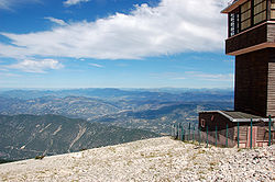 Summit Mont Ventoux
In September 2008, it was announced by Claude Haut, the president of the Vaucluse province, that in 2009 the Tour de France would visit Mont Ventoux after a seven-year absence. Unusually, the riders climbed the "Giant of Provence" on the second-to-last day of the race, on July 25, 2009, prior to transferring to Paris for the traditional parade on the Champs-Élysées.
Year Stage Start of stage Distance (km) Category Stage winner Nationality Yellow jersey 1958 18 Bédoin 21.5 (ITT) 1 Charly Gaul  Luxembourg
Raphaël Geminiani 1965 14 Montpellier 173 1 Raymond Poulidor FranceFelice Gimondi 1970 14 Gap 170 1 Eddy Merckx  Belgium
Eddy Merckx 1972 11 Carnon-Plage 207 1 Bernard Thévenet FranceEddy Merckx 1987 18 Carpentras 36.5 (ITT) HC Jean-François Bernard FranceJean-François Bernard 2000 12 Carpentras 149 HC Marco Pantani  Italy
ItalyLance Armstrong 2002 14 Lodève 221 HC Richard Virenque FranceLance Armstrong 2009 20 Montélimar 167 HC Juan Manuel Gárate  Spain
SpainAlberto Contador Other appearances in Tour de France
The race has also crossed the summit six times.
Year Stage Category Start Finish Leader at the summit Nationality 1951 18 1 Montpellier Avignon Lucien Lazarides France1952 14 1 Aix-en-Provence Avignon Jean Robic France1955 11 1 Marseille Avignon Louison Bobet France1967 13 1 Marseille Carpentras Julio Jiménez Spain1974 12 1 Savines-le-Lac Orange Gonzalo Aja Spain1994 15 HC Montpellier Carpentras Eros Poli ItalyIn 1951, the approach to the summit was from Malaucène. In all other years, the approach has been from Bédoin
The climb from Bédoin to the Mont Ventoux
The climb by bike from Bédoin to Mont Ventoux is one of the toughest in professional cycling. Every climb has its own unique particulars. To get a detailed impression of this climb, the route has been measured accurately.
The figure for the average gradients per kilometre can be found in many books and websites on cycling. The average gradient of the total climb and also the average gradients per kilometre differ slightly, depending on the source of the information. Accurate measurements result in an average gradient for the total climb of 7.43%, based on a horizontal distance of 21765 metres and an ascent height of 1617 metres. The actual distance ridden is 21825 metres.
The average gradients per kilometre are as follows:
Kilometre Average gradient Kilometre Average gradient 1 1.9 % 12 10.1 % 2 2.8 % 13 9.2 % 3 3.8 % 14 9.4 % 4 5.8 % 15 8.8 % 5 5.6 % 16 6.9 % 6 3.1 % 17 6.6 % 7 8.6 % 18 6.8 % 8 9.4 % 19 7.4 % 9 10.5 % 20 8.3 % 10 10.1 % 21 9.1 % 11 9.3 % 22 10.0 % Skiing
There is a small skiing facility on the northern face of Mont Ventoux. High winds and the modest elevation tend to limit the amount of time when this is open to the public.
See also
- List of highest paved roads in Europe
- List of mountain passes
References
- ^ "Mont Ventoux". Peakbagger.com. http://www.peakbagger.com/peak.aspx?pid=9913. Retrieved 2010-07-04.
- ^ [1]
- ^ Lynn Thorndike, Renaissance or Prenaissance, Journal of the History of Ideas, Vol. 4, No. 1. (Jan., 1943), pp. 69-74. JSTOR link to a collection of several letters in the same issue.
- ^ "Notes". Nature 21: 18–19. November 6, 1879. doi:10.1126/science.ns-21.519.18. http://books.google.com/books?id=ocsKAAAAYAAJ&pg=PA19&lpg=PA19. Retrieved 2011-04-19.
- ^ Site from Velo101.com
External links
- Petrarch's ascent of Mt. Ventoux (in English)
- Cycling Route details and GPX files Bedoin side
- Cycling Route details and GPX files Malaucene side
- Mont Ventoux: Picture Gallery
- Ventoux Confirmed for 2009: [2][3]
- Velo News: The curse of the Ventoux
- Réserve de Biosphère du Mont Ventoux (French)
- Winter picture of Mont Ventoux
- Mont Ventoux cycling - Pictures and profiles (French)
- Les montagnes du Tour de France - Le Mont Ventoux (French)
- Le Mont Ventoux dans le Tour de France (French)
- 2009 route of the Tour de France
- www.mont-ventoux.be - pictures, stories, nice percentage graphs for the active biker (in Dutch)
- Grenoble Cycling Mont Ventoux information page including profile and photos
- How to do Les Cingles
- Les Cingles report and photos
Categories:- Mountains of France
- Climbs in cycle racing
- Vaucluse
- 2000 Tour de France
- Biosphere reserves of France


Wikimedia Foundation. 2010.