- B & O Railroad Potomac River Crossing
Infobox_nrhp | name =B & O Railroad Potomac River Crossing
nrhp_type =
caption =
location=Harper's Ferry, West Virginia
lat_degrees = 39
lat_minutes = 19
lat_seconds = 27
lat_direction = N
long_degrees = 77
long_minutes = 43
long_seconds = 43
long_direction = W
locmapin = West Virginia
area =
built =1851
architect= Bollman,Wendel; Et al.
architecture= Other
added =February 14 ,1978 cite web|url=http://www.nr.nps.gov/|title=National Register Information System|date=2008-04-15|work=National Register of Historic Places|publisher=National Park Service]
governing_body = Private
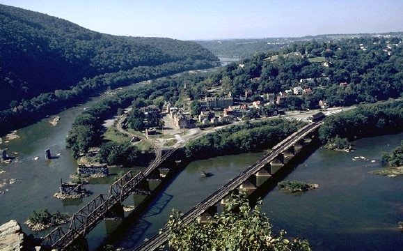
refnum=78001484The Baltimore and Ohio Railroad Crossings at the Potomac River are a set of
railroad bridges that span thePotomac River betweenMaryland Heights ,Maryland andHarpers Ferry, West Virginia . Two bridges comprise the current crossing. The more recent bridge is a deckplate girder bridge dating to 1930-31 which curves across the river, carrying theBaltimore and Ohio Railroad main line toMartinsburg, West Virginia . The older bridge is a steelPratt truss and plate girder bridge dating to 1894, carrying the B&O Valley line towardWinchester, Virginia along theShenandoah River . A tunnel was built at the same time as the 1894 bridge to carry the tracks through Maryland Heights and to eliminate a sharp curve. The western end of the tunnel was widened in conjunction with the construction of the second bridge to allow the broadest possible curve across the river.Just downstream of the 1894 bridge, almost at the confluence of the Potomac and Shenandoah Rivers, are the ruins of two previous bridges on the same alignment. The newer of the bridges was a
Bollman truss bridge that carried rail and highway traffic from 1870 until 1936, when it was swept away by a flood. The Valley line section of the Y-shaped bridge dated to 1851, and was one of the earliest Bollman trusses in existence. The remainder of the bridge was destroyed in the Civil War, to be replaced by temporary structures. Its predecessor, built in 1824, was designed byBenjamin H. Latrobe was a timbercovered bridge , with the Y-leg to Winchester added in 1839. An earlier road bridge had been built in 1824, replacing Harper's Ferry, which had operated since 1747.citation|title=PDFlink| [http://www.wvculture.org/shpo/nr/pdf/jefferson/78001484.pdf National Register of Historic Places Nomination: B & O Railroad Potomac River Crossing] |837 KB|date=June 26, 1973 |author=Paula Stoner Dickey and Robert M. Vogel|publisher=National Park Service]ee also
*
Harpers Ferry National Historical Park
*Harpers Ferry Historic District References
Wikimedia Foundation. 2010.