- College Corner, Ohio
-
College Corner, Ohio — Village — Location of College Corner, Ohio
Coordinates: 39°34′4″N 84°48′45″W / 39.56778°N 84.8125°WCoordinates: 39°34′4″N 84°48′45″W / 39.56778°N 84.8125°W Country United States State Ohio Counties Preble, Butler Area - Total 0.3 sq mi (0.7 km2) - Land 0.3 sq mi (0.7 km2) - Water 0.0 sq mi (0.0 km2) Elevation[1] 981 ft (299 m) Population (2000) - Total 424 - Density 1,592.5/sq mi (614.9/km2) Time zone Eastern (EST) (UTC-5) - Summer (DST) EDT (UTC-4) ZIP code 45003 Area code(s) 513 FIPS code 39-16700[2] GNIS feature ID 1060986[1] 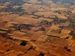 College Corner (top) and West College Corner, Indiana from the air looking east. The state line runs almost horizontally across the top of the picture, along State Line Road.
College Corner is a village in the southwestern part of the U.S. state of Ohio in Butler and Preble Counties, five miles northwest of Oxford. It was settled in 1811 and takes its name from its position in the northwestern corner of the "College Township", the survey township designated the previous year by the Ohio General Assembly as the site of the state college that became Miami University. This survey township was later organized as a civil township, Oxford Township. The population was 424 at the 2000 census.
The village lies on the state line with Indiana and there is a West College Corner, Indiana. The public school is bisected by the state line and is operated jointly with the Indiana authorities.
The Preble County portion of College Corner is part of the Dayton Metropolitan Statistical Area, while the Butler County portion is part of the Cincinnati–Middletown, OH-KY-IN Metropolitan Statistical Area.
Contents
Geography
College Corner is located at 39°34′4″N 84°48′45″W / 39.56778°N 84.8125°W (39.567851, -84.812537)[3].
According to the United States Census Bureau, the village has a total area of 0.3 square miles (0.7 km²).None of the area is covered with water.
Demographics
As of the census[2] of 2000, there were 424 people, 203 households, and 106 families residing in the village. The population density was 1,592.5 people per square mile (606.3/km²). There were 225 housing units at an average density of 845.1 per square mile (321.8/km²). The racial makeup of the village was 98.82% White, 0.24% African American, and 0.94% from two or more races.
There were 203 households out of which 27.1% had children under the age of 18 living with them, 42.4% were married couples living together, 6.9% had a female householder with no husband present, and 47.3% were non-families. 40.4% of all households were made up of individuals and 11.3% had someone living alone who was 65 years of age or older. The average household size was 2.09 and the average family size was 2.82.
In the village the population was spread out with 23.8% under the age of 18, 11.6% from 18 to 24, 32.1% from 25 to 44, 22.6% from 45 to 64, and 9.9% who were 65 years of age or older. The median age was 32 years. For every 100 females there were 104.8 males. For every 100 females age 18 and over, there were 99.4 males.
The median income for a household in the village was $33,611, and the median income for a family was $40,833. Males had a median income of $31,406 versus $21,964 for females. The per capita income for the village was $14,568. About 6.3% of families and 8.8% of the population were below the poverty line, including 12.5% of those under age 18 and none of those age 65 or over.
Historic population figures
- 1900—378
- 1910—181
- 1920—162
- 1930—375
- 1940—379
- 1950—458
- 1960—676
- 1970—697
- 1980—809
- 1990—755
References
- ^ a b "US Board on Geographic Names". United States Geological Survey. 2007-10-25. http://geonames.usgs.gov. Retrieved 2008-01-31.
- ^ a b "American FactFinder". United States Census Bureau. http://factfinder.census.gov. Retrieved 2008-01-31.
- ^ "US Gazetteer files: 2010, 2000, and 1990". United States Census Bureau. 2011-02-12. http://www.census.gov/geo/www/gazetteer/gazette.html. Retrieved 2011-04-23.
Further reading
- Bert S. Barlow, W.H. Todhunter, Stephen D. Cone, Joseph J. Pater, and Frederick Schneider, eds. Centennial History of Butler County, Ohio. Hamilton, Ohio: B.F. Bowen, 1905.
- Jim Blount. The 1900s: 100 Years In the History of Butler County, Ohio. Hamilton, Ohio: Past Present Press, 2000.
- Butler County Engineer's Office. Butler County Official Transportation Map, 2003. Fairfield Township, Butler County, Ohio: The Office, 2003.
- Bill Geist, reporter, and Amy Rosner, producer. "Time Line". CBS Sunday Morning. CBS Television. April 10, 2005. [1]
- A History and Biographical Cyclopaedia of Butler County, Ohio with Illustrations and Sketches of Its Representative Men and Pioneers. Cincinnati, Ohio: Western Biographical Publishing Company, 1882. [2]
- Ohio. Secretary of State. The Ohio municipal and township roster, 2002-2003. Columbus, Ohio: The Secretary, 2003.
External links
Municipalities and communities of Butler County, Ohio County seat: Hamilton Cities Fairfield‡ | Hamilton | Middletown‡ | Monroe‡ | Oxford | Sharonville‡ | Trenton

Villages College Corner‡ | Jacksonburg | Millville | New Miami | Seven Mile | Somerville
Townships CDPs Unincorporated
communitiesAlert | Bethany | Collinsville | Darrtown | Excello | Maud | Miltonville | McGonigle | Okeana | Overpeck | Poasttown | Port Union | Scipio | Shandon | Tylersville | West Middletown | Woodsdale
Footnotes ‡This populated place also has portions in an adjacent county or counties
Municipalities and communities of Preble County, Ohio County seat: Eaton City 
Villages College Corner‡ | Camden | Eldorado | Gratis | Lewisburg | New Paris | Verona‡ | West Alexandria | West Elkton | West Manchester
Townships Unincorporated
communitiesFootnotes ‡This populated place also has portions in an adjacent county or counties
Categories:- Populated places established in 1811
- Villages in Ohio
- Populated places in Butler County, Ohio
- Populated places in Preble County, Ohio
- Greater Dayton
- Municipalities of Greater Cincinnati


Wikimedia Foundation. 2010.