Oastler Lake Provincial Park
Look at other dictionaries:
Oastler Park Drive — is a road in the Canadian province of Ontario. Located within the Parry Sound District, the road serves as the primary access to Oastler Lake Provincial Park.A former alignment of Highway 69, the road extends from Bowes Street in Parry Sound… … Wikipedia
Provincial highways in Ontario — The Ontario Ministry of Transportation maintains the system of provincial highways in the Canadian province of Ontario. Highway classes Ontario has several distinct classes of highways (French voie publique ): King s Highways, (which includes… … Wikipedia
List of Ontario parks — This is the list of all national and provincial parks in Ontario, Canada.National parksParks administered by Parks Canada: *Bruce Peninsula National Park *Fathom Five National Marine Park *Georgian Bay Islands National Park *Point Pelee National… … Wikipedia
List of protected areas of Ontario — This is a list of protected areas of Ontario. Algonquin Provincial Park, Cache Lake … Wikipedia
Parry Sound, Ontario — Parry Sound Town Looking over the town and the sound … Wikipedia
Sunny Point Resort, Cottages & Inn — (Otter Lake,Канада) Категория отеля: Адрес: 41 Sunny Point Road, P2A 2W8 O … Каталог отелей
Ontario Highway 400 — Highway 400 Toronto–Barrie Highway … Wikipedia
Highway 518 (Ontario) — Highway 518 is a provincial secondary highway in the Canadian province of Ontario. Highway 518 spans 79 kilometers (49 miles) from its western and eastern termini. It serves as one of the many links between Highway 400 and Highway 11. Its route… … Wikipedia
Ontario Highway 518 — Highway 518 Route information Length: 72.7 km[3] (45.2 mi) … Wikipedia
Bradford — For the larger local government district, see City of Bradford. For other uses, see Bradford (disambiguation). Coordinates … Wikipedia
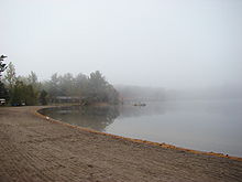 Oastler Lake Provincial Park in 2007.
