- Solec Kujawski
Infobox Settlement
name = Solec Kujawski
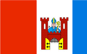
image_shield = POL Solec Kujawski COA.svg
pushpin_
subdivision_type = Country
subdivision_name = POL
subdivision_type1 = Voivodeship
subdivision_name1 = Kuyavian-Pomeranian
subdivision_type2 = County
subdivision_name2 = Bydgoszcz
subdivision_type3 =Gmina
subdivision_name3 = Solec Kujawski
area_total_km2 = 18.68
population_as_of = 2006
population_total = 15060
population_density_km2 = auto
latd = 53 | latm = 5 | lats = | latNS = N | longd = 18 | longm = 14 | longs = | longEW = E
elevation_m =
postal_code_type = Postal code
postal_code = 86-050
website = http://www.soleckujawski.plSolec Kujawski [IPA-pl|'|s|o|l|e|c|-|k|u|'|j|a|f|s|k|i] ( _de. Schulitz) is a town with 15,505 inhabitants and an area of 176 km², situated 14 kilometres southeast of
Bydgoszcz inPoland at coord|53|4|N|18|14|E. Solec Kujawski belongs to theKuyavian-Pomeranian Voivodeship . The town featuresSaint Stanislaus in its coat of arms.Urban parts
*Makowiska
*Otorowo
*Przyłubie
*Solec Kujawski - City
*WypaleniskaMassacre during Second World War
During the German
Invasion of Poland in 1939,Wehrmacht soldiers and local German minority members murdered 44 people from the town on 14th September. Some of the victims were brutally beaten with rifles(up to the point that they broke apart). [Szymon Datner "55 dni Wehrmachtu w Polsce" page 387-388] .Points of interest
South of Solec Kujawski there is the
longwave-transmitter Solec Kujawski .


Wikimedia Foundation. 2010.