- Barani Department
Infobox Settlement
name =Barani
settlement_type =Department
official_name =
other_name =
native_name =
nickname =
motto =
imagesize =
image_caption =
flag_size =
image_
seal_size =
image_shield =
shield_size =
image_blank_emblem =
blank_emblem_size =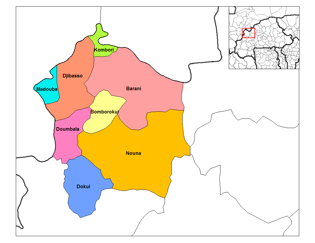
mapsize = 350px
map_caption = PAGENAME location in the province
mapsize1 =
map_caption1 =
pushpin_
pushpin_label_position =
subdivision_type = Country
subdivision_name = flag|Burkina Faso
subdivision_type1 = Province
subdivision_name1 =Kossi Province
subdivision_type2 =
subdivision_name2 =
seat_type =
seat =
government_type =
leader_title =
leader_name =
leader_title1 =
leader_name1 =
established_title =
established_date =
area_magnitude =
unit_pref =Imperial
area_footnotes =
area_total_km2 =
area_land_km2 =
area_water_km2 =
area_total_sq_mi =
area_land_sq_mi =
area_water_sq_mi =
area_water_percent =
area_urban_km2 =
area_urban_sq_mi =
area_metro_km2 =
area_metro_sq_mi =
population_as_of = 1996
population_footnotes =
population_note =
population_total = 49,144
population_density_km2 =
population_density_sq_mi =
population_metro =
population_density_metro_km2 =
population_density_metro_sq_mi =
population_urban =
population_density_urban_km2 =
population_density_urban_mi2 =
timezone = GMT 0
utc_offset = +0
timezone_DST =
utc_offset_DST =
latd=|latm=|lats=|latNS=
longd=|longm=|longs= |longEW=
elevation_footnotes =
elevation_m =
elevation_ft =
postal_code_type =
postal_code =
area_code =
website =
footnotes =Barani is a department or commune of
Kossi Province in westernBurkina Faso . Its capital lies at the town of Barani. According to the 1996 census the department has a total population of 49,144 [ [http://www.inforoute-communale.gov.bf/list_vill/bm.htm Burkinabé government inforoute communale] ] .The department of Barani borders the country of
Mali to the north. The village of Barani is most well known as the site of an annual horse festival [ [http://www.timesonline.co.uk/tol/travel/destinations/africa/article4076187.ece] ] . It can be reached via a road heading north from the village ofBomborokui .Towns and villages
*
Barani (4 804 habitants) (capital)
*Babakuy (1 094 habitants)
*Bangassi-Koro (420 habitants)
*Bangassi Kourou (4 804 habitants)
*Berma (1 450 habitants)
*Bogo (327 habitants)
*Boulé (491 habitants)
*Boulemporo (1 397 habitants)
* Cissé (918 habitants)
*Diamahoun (1 348 habitants)
*Djallo (510 habitants)
*Dienwely (534 habitants)
*Douré (413 habitants)
*Illa (1 633 habitants)
*Kamandadougou (1 068 habitants)
*Karekuy (1 003 habitants)
*Kessekuy (1 053 habitants)
*Kinseré (1 334 habitants)
*Kolonkan Goure Ba (616 habitants)
*Kolonkan Goure Diall (1 293 habitants)
*Konkoro (594 habitants)
*Koroni (762 habitants)
*Koubé (575 habitants)
*Koulerou (1 978 habitants)
*Manekuy (576 habitants)
*Mantamou (1 086 habitants)
*Medougou (1 766 habitants)
*Nabasso (881 habitants)
*Niako (479 habitants)
*Niemini-Peulh (137 habitants)
*Gnimanou (2 176 habitants)
*Ouemboye (382 habitants)
*Oueressé (1 384 habitants)
*Pampakuy (559 habitants)
*Sekuy (576 habitants)
*Sekuy-Ira (62 habitants)
*Sokoura (2 280 habitants)
*Soudogo (670 habitants)
*Tira (779 habitants)
*Torokoto (2 991 habitants)
*Waribèrè (961 habitants)
*Yalankoro (980 habitants)References
Wikimedia Foundation. 2010.