- Manandoana
-
Manandoana Location in Madagascar
 Manandoana
Coordinates: 20°3′S 47°4′E / 20.05°S 47.067°E Country  Madagascar
Region Vakinankaratra District Antsirabe II Elevation[1] 1,605 m (5,266 ft) Population (2001)[2] – Total 10,000 – Ethnicities Merina Time zone EAT (UTC3) Manandoana is a town and commune in Madagascar. It belongs to the district of Antsirabe II, which is a part of Vakinankaratra Region. The population of the commune was estimated to be approximately 10,000 in 2001 commune census.[2]
Primary and junior level secondary education are available in town. The majority 90% of the population of the commune are farmers, while an additional 10% receives their livelihood from raising livestock. The most important crops are rice and barley, while other important agricultural products are wheat and potatoes.[2]
References and notes
- ^ Estimated based on DEM data from Shuttle Radar Topography Mission
- ^ a b c "ILO census data". Cornell University. 2002. http://www.ilo.cornell.edu/ilo/data.html. Retrieved 2008-04-22.
Ambatolampy 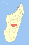
Antanifotsy Antsirabe Antsirabe II Alakamisy · Ambano · Ambatomena · Ambohibary · Ambohidranandriana · Ambohimiarivo · Ambohitsimanova · Andranomanelatra · Antanambao · Antanimandry · Antsoatany · Belazao · Ibity · Manandoana · Mandrosohasina · Mangatano · Sahanivotry Mandona · Soanindrariny · Tsarahonenana Sahanivotry · VinaninkarenaBetafo Alakamisy Antivato · Alarobia Bemaha · Ambatonikonilahy · Ambohimanambola · Ambohimasina · Andrembesoa · Anjoma Ramartina · Ankazomiriotra · Antsotso · Betafo · Fidirana · Inanantona · Mahaiza · Mandoto · Mandritsara · Soavina · Tritriva · VasianaFaratsiho Coordinates: 20°3′S 47°4′E / 20.05°S 47.067°E

This Vakinankaratra location article is a stub. You can help Wikipedia by expanding it.

