- Gens de Terre River
Geobox|River
name = Gens de Terre River
native_name =
other_name = Rivière Gens de Terre
category =
etymology =
nickname =
image_caption =
country = Canada
state = Quebec
region = Outaouais
district =
municipality =
parent =
tributary_left =
tributary_right =
city =
landmark =
source = Cabonga Reservoir
source_location =
source_region =
source_country =
source_elevation = 355
source_lat_d = 47 | source_lat_m = 18 | source_lat_s = 34 | source_lat_NS = N
source_long_d = 76 | source_long_m = 28 | source_long_s = 6 | source_long_EW = W
mouth = Baskatong Reservoir
mouth_location =
mouth_region =
mouth_country =
mouth_elevation = 235
mouth_lat_d = 46 | mouth_lat_m = 52 | mouth_lat_s = 6 | mouth_lat_NS = N
mouth_long_d = 75 | mouth_long_m = 57 | mouth_long_s = 18 | mouth_long_EW = W
length = 115
width =
depth =
volume =
watershed =
discharge =
discharge_max =
discharge_min =
free =
free_type =
map_caption =
map_background =
map_locator =
map_locator_x =
map_locator_y =
website =
footnotes =The Gens de Terre River (in French: "Rivière Gens de Terre", literal meaning: "people of the land") is a river in central Quebec, Canada. It is located on the eastern edge of the
La Vérendrye Wildlife Reserve in the Vallée-de-la-Gatineau County Municipality in theOutaouais region . Its source is theCabonga Reservoir from where it flows in a mostly southern direction for 115 km and drains into the Gens de Terre Bay of theBaskatong Reservoir .cite web |url=http://www.toponymie.gouv.qc.ca/ct/topos/carto.asp?Speci=25023&Latitude=46,8875&Longitude=-76,01944&Zoom=1700 |title=Rivière Gens de Terre |accessdate=2008-04-04 |publisher=Commission de toponymie du Québec |language=French]Tributaries include:
*Bélinge River
*Wapus River
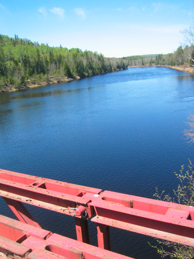
*Serpent RiverThe section of the river between the Wapus River and the iron bridge downstream is breathtaking with m to ft|25|precision=-1 cliffs on both sides. This km to mi|25 section is marked by continuous class II-IV
whitewater , and should only be paddled by expert canoers.cite web |url=http://www.paddlefoot.ca/rivers.htm |title=Rivers PaddleFoot Trips Travel |accessdate=2008-04-04 |publisher=Paddlefoot Inc] The flow of the river depends greatly on the water level management in the Cabonga Reservoir.History
The name of the river may be attributed to
Louis Antoine de Bougainville (1729-1811),aide-de-camp to Marquis de Montcalm. In 1757, he wrote in his journal: "Têtes-de-Boule" brought by the Nipissings. Those savages are also called people of the land ("gens des terres"), live in the woods, are great hunters, mediocre warriors, neither have police nor politics, trade more with the English at the Hudson Bay than with us". And in a memo from 1759, Bougainville wrote: "The nations that deal there are the "Têtes-de-Boules" (Atikamekw ) or people of the land and the Namcosakio who come from towards the Hudson Bay."The name "Gens de Terre" was probably assigned by voyageurs or fur traders as a reminder of this native American nomadic tribe, whose territory stretched between the upper basins of the Saint-Maurice, Gatineau, and Ottawa Rivers. It has been used in official documents since at least 1867.
In the early twentieth century, the river was called Bark River by the English.
The river has long been used by loggers for
log driving . The log drivers were nicknamed "La Maline" (the malignant) because of the obstacles and difficulties that were found along the route.References
External links
* [http://192.77.51.34/~cleduc/Canot/04/GensDeTerreLeduc.pdf Canoeing description and map] (in French)
Wikimedia Foundation. 2010.