- County Borough of Rochdale
-
Not to be confused with Metropolitan Borough of Rochdale.
Rochdale Motto: Crede Signo (Believe in this sign) 
Rochdale Town HallGeography Status Municipal borough 1856–1889
County borough 1889–19741911 area 6,446 acres (26.09 km2) 1961 area 9,556 acres (38.67 km2) HQ Rochdale Town Hall History Created 1856 Abolished 1974 Succeeded by Metropolitan Borough of Rochdale Demography 1901 population 83,114 1971 population 91,428 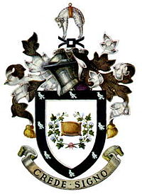
Rochdale was, from 1856 to 1974, a local government district coterminate with the town of Rochdale in the northwest of England.[1]
Contents
Municipal borough
In January 1856 the inhabitant householders of the Parliamentary Borough of Rochdale, Lancashire, petitioned the Privy Council for the grant of a charter of incorporation under the Municipal Corporations Act constituting the town as a municipal borough.[2] The petition was successful and the charter was granted in September 1856.[3] In 1858 the borough corporation took over the powers of the Rochdale Improvement Commissioners, which had been established by private act of parliament in 1825 to watch, light and cleanse the town. The borough was extended in 1872.[4]
County borough
The Local Government Act 1888 constituted all municipal boroughs with a population of more than 50,000 as "county borough"s. Accordingly, the County Borough of Rochdale came into existence in 1889, with the powers of both a borough and a county council. Rochdale remained within Lancashire for certain purposes such as lieutenancy and administration of justice.
In 1900 the county borough absorbed the bulk of the neighbouring Castleton Urban District by mutual agreement. [5] The borough boundaries were extended again in 1933 by a county review order.[6]
The county borough was abolished in 1974 by the Local Government Act 1972. Its area formed part of the Metropolitan Borough of Rochdale in the new county of Greater Manchester.
Borough council
Under the charter of 1856 the borough was governed by a town council consisting of a mayor, ten aldermen and thirty councillors. The borough was divided into three wards: Castleton and Wardleworth represented by twelve councillors and four aldermen each, and Spotland with six councillors and two aldermen.[4] One third of the councillors in each ward were elected annually by the burgesses or local government electors. The aldermen were elected to a six-year term by the council itself, with half the aldermanic bench retiring every three years. The mayor was elected annually by the council from among their membership.
When the borough was extended in 1872, the council seats were redistributed and the borough was divided into ten wards, each with three councillors and one alderman, with the size of the council remaining at forty.[4] When Castleton Urban District was absorbed in 1900, an eleventh ward of Castleton Moor was added, and the council increased to thirty-three councillors and eleven alderman.[4] In 1933 the bulk of Norden Urban District was added to the borough as a twelfth ward, and the council consisted of thirty-six councillors and twelve aldermen until its abolition in 1974.[7]
Politics
For the first seven decades of the borough's existence it was dominated by the Liberal Party, who maintained a large majority. Conservatives formed an opposition grouping, and Socialist and Independent Labour Party councillors appeared from the end of the nineteenth century. From the nineteen thirties the Liberal hegemony began to be challenged, with an increase in the number of Labour and Conservative members, and there was no one grouping in control. By the nineteen sixties control alternated between Liberals/Conservative and Labour administrations.
Election results 1933–1972
The following list shows the numbers of councillors and aldermen of each party following the annual borough elections. There were no elections from 1939 to 1944 due the Second World War. Elections due in November 1948 were postponed until May 1949, with municipal elections held in that month from then on. The final elections to the county borough council were held in 1972, with members holding office until abolition two years later.
Election Liberal Party Conservative Party Labour Party Independents Control 1933[8] 24 (-1) 16 (-1) 6 (+2) 1 Liberal hold 1934[9] 23 17 (-1) 7 (+1) 1 No overall control 1935[10] 24 17 7 0 Liberal hold 1936[11] 25 (+2) 15 (-1) 7 (-1) 1 Liberal gain form no overall control 1937[12] 24 (-1) 17 (+2) 6 (-1) 1 Liberal hold 1938[13] 23 (-1) 18 6 1 (+1) Liberal lose to no overall control 1945[14] 23 (-1) 16 (-2) 10 (+3) 1 No overall control 1946[15] 21 (-1) 17 9 (+1) 1 No overall control 1947[16] 25 (+4) 14 (-3) 8 (-1) 1 Liberal gain from no overall control 1949[17] 27 (+1) 14 (+1) 6 (-2) 1 Liberal hold 1950[18] 23 (-2) 17 (+2) 7 1 Liberal lose to no overall control 1951[19] 22 (-1) 16 (-1) 9 (+2) 1 No overall control 1952[20] 18 (-3) 12 (-4) 17 (+7) 1 No overall control 1953[21] 16 (-1) 12 (-1) 19 (+2) 1 No overall control 1954[22] 14 (-2) 12 (-1) 22 (+3) 0 (-1) No overall control 1955[23] 16 (+2) 13 (+3) 17 (-5) 0 No overall control 1956[24] 16 13 (-1) 19 (+1) 0 No overall control 1957[25] 16 12 20 0 No overall control 1958[26] 15 (-1) 11 (-1) 22 (+2) 0 No overall control 1959[27] 16 (+2) 12 (+1) 20 (-3) 0 No overall control 1960[28] 17 11 (-1) 20 (+1) 0 No overall control 1961[29] 17 (+1) 11 19 (-1) 1 No overall control 1962[30] 15 (-2) 8 (-3) 23 (+4) 2 (+1) Liberal with Conservative support 1963[31] 14 (-1) 7 (-1) 26 (+3) 1 (-1) Labour gain from Liberal - Conservative 1964[32] 12 (-1) 5 (-2) 30 (+3) 1 Labour hold 1965[33] 13 (+1) 10 (+5) 25 (-5) 0 (-1) Labour hold 1966[34] 13 11 24 0 Labour lose to no overall control 1967[35] 14 (+1) 14 (+3) 15 (-4) 5 No overall control 1968[36] 19 (+1) 18 (+3) 11 (-3) 0 (-1) No overall control 1969[37] 20 (+1) 21 (+3) 7 (-4) 0 No overall control 1970[38] 15 (-2) 19 (-4) 12 (+6) 1 No overall control (1 vacancy) 1971[39] 11 (-2) 14 (-5) 22 (+7) 1 No overall control 1972[40] 9 (-4) 11 (-1) 28 (+6) 0 (-1) Labour gain from no overall control Coat of arms
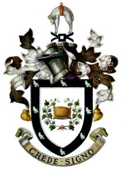
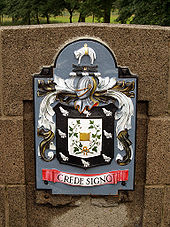 The coat of arms of the former Rochdale County Borough Council.
The Mayor, Aldermen and Burgesses of Rochdale were granted armorial bearings by letters patent dated 20 February 1857 sealed by Sir Charles George Young, Garter Principal King of Arms; James Pulman, Clarenceux King of Arms; and Robert Laurie, Norroy King of Arms.[41]
The blazon was as follows:
Argent a wool-pack encircled by two branches of the cotton-tree flowered and conjoined proper, a bordure sable, charged with eight martlets of the field. And for the Crest: Upon a wreath of the colours, a mill-rind sable, and above a fleece argent banded or.[41]
The emblems in the centre of the shield represented the industries of the borough: a fleece for the woollen industry; the cotton branches for the cotton industry; and the millrind for the iron industry. The black border bore six martlets or heraldic swallows. The martlets and black and silver colouring were derived from the arms of the Rashdale and Dearden families.[42] James Dearden purchased the manor of Rochdale from Lord Byron in 1823.[4]
The crest, placed on a helm above the shield, represented the wool and iron industries with a fleece and millrind.[42]
The Latin motto adopted was Crede Signo or "Trust in this sign". It was based on that of Baron Byron of Rochdale: Crede Byron.[42]
Utilities
Rochdale, in common with many British municipalities, took over the ownership and provision of a number of utility services.
Gas supply
In 1824 the Rochdale Gas Light and Coke Company opened a gasworks at what would later be Dane Street.[43] Following a dispute with the Rochdale Police Commissioners over the price of providing public street lighting, the Commissioners promoted a private act of parliament and acquired the undertaking in 1844, and in 1858 they passed to the borough.[4] In 1871 the corporation began rebuilding and enlarging the gasworks.[44] In the 1930s the Whitworth Vale and Milnrow gas companies were acquired. By 1948 the undertaking supplied the County Borough of Rochdale and the urban districts of Milnrow, Wardle and Whitworth.[45] The corporation lost control of the undertaking to the North-Western Gas Board when gas supply was nationalised by the Gas Act 1948.
Water supply
A supply of drinking water was introduced to the town by a private company in 1809. In 1866 the borough corporation took control.[4] The original reservoir at Leyland Brow proved insufficient for the town, and in 1898 Ramsden Reservoir was acquired along with the Todmorden Waterworks Company. As the town grew it was clear that a larger supply would be needed, and in 1923 Rochdale and Oldham County Boroughs jointly acquired the reservoirs of the Rochdale Canal Company.[45] Watergrove Reservoir, near Wardle was constructed in 1938.[45][46]
In 1967 the Rochdale Corporation water undertaking was merged with those of Ashton-under-Lyne, Dukinfield, Heywood, Middleton, Oldham, Saddleworth and Stalybridge to form the West Pennine Water Board.[47] The water board was in turn merged into the North West Water Authority by the Water Act 1973.
Electricity
In 1896 the borough council resolved to establish a municipal electricity supply to the town, and in particular to power the tramway system. A generating station was constructed near the gasworks, and power began to flow in October 1900.[44] As electricity began to be adopted for industrial purposes it was necessary to construct larger generating facilities in 1919. An interconnection agreement was also established with the Lancashire Electric Power Company. By the 1930s the corporation electricity department also supplied the neighbouring urban districts of Littleborough, Milnrow, Norden, Wardle and Whitworth.[45]
By 1930 domestic demand for electricity was well established, and the electricity department opened an appliance showroom: "Electric House", in Smith Street.[48]
On 1 April 1948 the Electricity Act 1947 came into effect, and the undertaking was nationalised, becoming part of the North Western Electricity Board.[45]
Rochdale Corporation Transport
In 1881 the Board of Trade made an order under the Tramways Act 1870, giving Rochdale Corporation powers to construct a street tramway.[49] The line was opened on 7 May 1883 and was operated by the steam trams of the Manchester, Bury, Rochdale and Oldham Steam Tramways Company Limited. The company went into liquidation in 1887, but in the following year the service was restored under the auspices of the Bury, Rochdale and Oldham Steam Tramways Company Limited.[50]
In 1900 the Corporation obtained powers to operate the trams itself, and the borough council purchased and electrified the tram network, with the first Rochdale Corporation tram running on 22 May 1902. The last steam tram route was replaced in 1905. In 1911 Rochdale made agreements with two neighbouring municipalities, the borough of Bacup and Milnrow Urban District, to operate the tram networks they had constructed. In addition the corporation tracks reached as far as Littleborough and Whitworth, and ran joint operations with other municipal operators. In 1925 the county borough purchased the Middleton Electric Tramways Company jointly with the Municipal Borough of Middleton and Chadderton Urban District Council. The purchase allowed through running of Rochdale trams into Manchester city centre.[50]
The corporation began operating motorbus services in 1926, initially in addition to the tram network. 1930 saw the first replacement of trams with buses, and the last tram service ran on 12 November 1932. The borough's bus services expanded as new estates were built on the edge of the town.[50]
On 1 November 1969 the corporation ceased to operate buses, with its transport department merged with those of a number of other municipalities to form the new SELNEC Passenger Transport Executive. Rochdale contributed 130 vehicles to the new undertaking's fleet of 2,526.
References
- ^ "A vision of Rochdale CB/MB". A Vision of Britain through time. University of Portsmouth. http://www.visionofbritain.org.uk/unit_page.jsp?u_id=10136945. Retrieved 2008-10-24.
- ^ London Gazette: no. 21845. p. 365. 1856-02-01. Retrieved 2008-07-09.
- ^ Norman Moorsom. "Rochdale's Charter of Incorporation (and Letters)". Link 4 Life. Rochdale Boroughwide Community Trust. http://www.link4life.org/index.cfm?fuseaction=c.showPage&pageID=788. Retrieved 2008-07-09.
- ^ a b c d e f g William Farrer & J. Brownbill (editors) (1911). "The parish of Rochdale". A History of the County of Lancaster Volume 5. British History Online. http://www.british-history.ac.uk/report.aspx?compid=53027. Retrieved 2008-10-23.
- ^ Rochdale Observer (2003-06-11). "The 1890s". http://www.rochdaleobserver.co.uk/news/s/33/33152_the_1890s.html. Retrieved 2007-06-15.
- ^ "Greater Manchester Gazetteer". Greater Manchester County Record Office. Places names - O to R. http://www.gmcro.co.uk/Guides/Gazeteer/gazzo2r.htm. Retrieved 23 October 2008.
- ^ F.A, Youngs, Jr., Guide to the Local Administrative Units of England, Vol.II: Northern England, London, 1991
- ^ The Times, 2 November 1933, p.14
- ^ The Times, 3 November 1934, p.7
- ^ The Times, 2 November 1935, p.14
- ^ The Times, 3 November 1936, p.18
- ^ The Times, 3 November 1937, p.19
- ^ The Times, 3 November 1938, p.9
- ^ The Times, 2 November 1945, p.8
- ^ The Times, 2 November 1946, p.2
- ^ The Times, 3 November 1947, p.6
- ^ The Times, 13 May 1949, p.3
- ^ The Times, 12 May 1950, p.4
- ^ The Times, 11 May 1951, p.4
- ^ The Times, 9 May 1952, p.3
- ^ The Times, 8 May 1953, p.4
- ^ The Times, 14 May 1954, p.3
- ^ The Times, 13 May 1955, p.15
- ^ The Times, 11 May 1956, p.5
- ^ The Times, 10 May 1957, p.6
- ^ The Times, 9 May 1958, p.6
- ^ The Times, 9 May 1959, p.8
- ^ The Times, 13 May 1960, p.10
- ^ The Times, 12 May 1961, p.6
- ^ The Times, 11 May 1962, p.10
- ^ The Times, 10 May 1963
- ^ The Times, 8 May 1964, p.10
- ^ The Times, 14 May 1965, p.8
- ^ The Times, 13 May 1966, p.13
- ^ The Times, 12 May 1967, p.3
- ^ The Times, 10 May 1968, p.8
- ^ The Times, 12 May 1969
- ^ The Times, 8 May 1970, p.4
- ^ The Times, 14 May 1971, p.5
- ^ The Times, 5 May 1972
- ^ a b A C Fox-Davies, The Book of Public Arms, 2nd edition, London, 1915
- ^ a b c W C Scott-Giles, Civic Heraldry of England and Wales, 2nd edition, London, 1953
- ^ "Fuel used to be regular, cheap - and poisonous". Nostalgia. Rochdale Observer. 2008-07-05. http://www.rochdaleobserver.co.uk/community/nostalgia/s/1056903_fuel_used_to_be_regular_cheap__and_poisonous. Retrieved 2008-10-25.
- ^ a b Rebe Taylor (1956). "Chapter 7: The First Fifty Years of Incorporation: 1856–1906". Rochdale Retrospect. Rochdale Boroughwide Cultural Trust. http://www.link4life.org/media/downloads/CAA5EE71-FAEB-ECE5-10A9F1BE265B46B3.pdf. Retrieved 2008-10-25.
- ^ a b c d e Rabe Taylor (1956). "Chapter 8: Towards the Centenary of the Borough". Rochdale Retrospect. Rochdale Boroughwide Cultural Trust. http://www.link4life.org/media/downloads/CAA9094D-EA04-73C3-94B0CA93147342F7.pdf. Retrieved 2008-10-25.
- ^ "Watergrove Reservoir". United Utilities. 2007. http://www.unitedutilities.com/?OBH=445&ID=3006. Retrieved 2008-10-25.
- ^ London Gazette: no. 44380. p. 8607. 1967-08-04.
- ^ "Success of current affairs was in house". Rochdale Observer. 2006-11-29. http://www.rochdaleobserver.co.uk/community/rochdale_150/shopping/s/520/520978_success_of_current_affairs_was_in_house.html. Retrieved 2008-10-25.[dead link]
- ^ London Gazette: no. 25042. p. 6272. 1881-11-29.
- ^ a b c Peter Gould. "Rochdale Corporation Transport 1902–1969". Local Transport History. http://www.petergould.co.uk/local_transport_history/fleetlists/rochdale.htm. Retrieved 2008-10-24.
External links
- A vision of Rochdale CB/MB, visionofbritain.org.uk.
Categories:- Local government in Rochdale
- Districts of England abolished by the Local Government Act 1972
- History of Rochdale
- County boroughs of England


Wikimedia Foundation. 2010.