- Chalampé
-
Chalampé
Chalampé / Eichwald (arch.)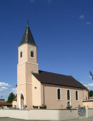

 ChalampéLocation within Alsace region
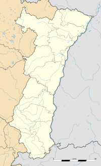 Chalampé
Administration Country France Region Alsace Department Haut-Rhin Arrondissement Mulhouse Canton Illzach Intercommunality Porte de France Rhin Sud Mayor Martine Laemlin-Delmotte
(2008–2014)Statistics Elevation 211–217 m (692–712 ft)
(avg. 215 m/705 ft)Land area1 4.77 km2 (1.84 sq mi) Population2 906 (2006) - Density 190 /km2 (490 /sq mi) INSEE/Postal code 68064/ 68490 Dialling code 0389 1 French Land Register data, which excludes lakes, ponds, glaciers > 1 km² (0.386 sq mi or 247 acres) and river estuaries. 2 Population without double counting: residents of multiple communes (e.g., students and military personnel) only counted once. Coordinates: 47°49′17″N 7°32′31″E / 47.8213888889°N 7.54194444444°E
Chalampé (German: Eichwald) is a commune in the Haut-Rhin department in Alsace in north-eastern France.
The town was founded by soldiers of Dubourg who in 1709 had beaten the Austrians under Count Claude Florimond de Mercy in the War of the Spanish Succession. It is located in an area called Eichwald (oak forest) by the otherwise German-speaking population of the Alsace, and bears its French name since 1735. Before Johann Gottfried Tulla and others straightened the Rhine in the 19th century, the river had changed its course several times, moving the border. Thus, the village was considered part of Germany occasionally.
See also
References
Categories:- Communes of Haut-Rhin
- Haut-Rhin geography stubs


Wikimedia Foundation. 2010.