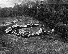
- Eneabba Stone Arrangement
-
Eneabba Stone Arrangement is the name given to a registration on the Western Australia's Register of Aboriginal Sites. [1] The arrangement is listed as being located at 29°56′43″S 115°5′46″E / 29.94528°S 115.09611°ECoordinates: 29°56′43″S 115°5′46″E / 29.94528°S 115.09611°E, about twelve kilometers (7.5 mi) east of the coastal town of Leeman, Western Australia. While the Western Australian Register of Aboriginal Sites lists it in Zone 50, Site Number S01963, it should be noted that the co-ordinates as listed were also stated as unreliable.[1]
In an effort to locate what is known as the Ring of Stones, expeditions were mounted by Rupert Gerritsen and others over a period of six years. The Eneabba Stone Arrangement came under investigation as a possible option for the Ring of Stones, but unfortunately it was not found at the registered location. In fact, the Eneabba Stone Arrangement was not locatable within the proximity of a 20 kilometre radius to its reported location. The Registrar of Aboriginal Sites was informed of this by letter on 31 October 2009, and the results of these expeditions were published in 2010. [2]
History
The first recorded European to sight the arrangement known as the Ring of Stones, as distinct from the Eneabba Stone Arrangement, was by surveyor Albert Earle Burt, who found it while engaged in a coastal survey in 1875. Burt and a companion had been raising trig points near the coast, but were forced to strike inland to obtain supplies. Unable to penetrate through an area of dense Acacia (Wattle) scrub, the men set fire to the bush. After the fire had died down, they proceeded inland, finding the arrangement in the area where the Acacia scrub had been thickest.[3]
Some time later, a Geraldton shepherd named William Stokes reported having found something which has been associated with the Ring of Stones while searching for lost sheep. He reported that he saw a line of stones running for approximately a mile through the bushlands. [3] Another man named King reported finding a line of stones pointing in the direction of the thicket although no locational information was given so the association is doubtful.[3]
Later, Burt formed the view that the arrangement was associated with the Vergulde Draeck. This view fired the imaginations of treasure seekers, as the Vergulde Draeck is known to have had on board 78,600 Dutch guilders in eight chests. In the words of Malcolm Uren,
"That treasure was buried somewhere in the locality of the Circle of Stones and he who could read aright the riddle of the Ring of Stones would be directed to a fortune."[3]Burt and a second expedition led by Constable Loxton tried to relocate the arrangement in 1931-32, but they were unsuccessful. In the late 1930s, an expedition under J. E. Hammond burned hundreds of acres of scrub and spend about a fortnight searching the area with the aid of a metal detector, but without success. Using Burt's original mudmap, recently discovered in Police archives, Gerritsen was able locate the site in October 2008, but the ring had been destroyed, probably by treasure seekers, with all the rocks put in a pile in the centre of the clearing. Late in 1938, a bushman named Gabriel Penney told Dongara Hotel publican Jack Hayes that he had come across a Ring of Stones seven years previously, and the two agreed to visit the site together. According to Hayes, "we walked for what I thought was about fifty miles but which Gabriel Penney said was seven or eight miles, and we emerged from the bush not twenty yards away from the Circle of Stones. In all my life I have never believed such a feat of bushmanship possible." Hayes took photographs and made sketches of the arrangement, then the men dug in the centre of the ring. They soon found that the soil was no more than two inches deep, beneath which was a flat surface of limestone. They found nothing of value.[3]. Subsequent research has established that this is a different feature to the Ring of Stones reported by Burt, being further inland, about 50 kilometres further north and of a different size and form.
Accounts of the discoveries by Burt, Penney and Hayes, Stokes and King were published in newspapers in Perth in the 1930s and by Uren in his 1940 Sailormen's Ghosts. Uren hosed down speculation of a connection with the Vergulde Draeck, stating "the theory has persisted because age has given it an air of verisimilitude it never rightly possessed. Far more likely is that the Circle of Stones had something to do with native rites."[3] Nonetheless, the myths surrounding the arrangement persisted. Even in the 2000s, the myth of "this elusive ring of stones" was still being reported.[4]
It is now accepted that the Ring of Stones is not the indigenous stone arrangement known as Eneabba Stone Arrangement but possibly constructed by European hands.[5]
Furthermore, while the Eneabba Stone Arrangement has been afforded listing on Western Australia's Register of Aboriginal Sites under the name Eneabba Stone Arrangement,[1] it has not been established with any certainty that such a site actually exists except on that register.[2]
References
- ^ a b c "Aboriginal Heritage Inquiry System". Department of Indigenous Affairs, Western Australia. http://www.dia.wa.gov.au/AHIS/.
- ^ a b Gerritsen, Rupert (2010). Marooned mariners and mudmaps: The search for the Ring of Stones, The Globe 64: 17 - 25.
- ^ a b c d e f Uren, Malcolm (1946). Sailormen's Ghosts (Sixth edition ed.). Melbourne: Robertson & Mullens.
- ^ Jeans, Peter D. (2007). Seafaring Lore & Legend. McGraw-Hill Professional. ISBN 0071435433. http://books.google.com/books?id=rf2uu5paRNQC. Retrieved 2008-02-13.
- ^ Gerritsen, Rupert (1994/2002). And Their Ghosts May Be Heard, South Fremantle: Fremantle Arts Centre Press.
Categories:- Indigenous Australian culture
- Australian Aboriginal culture
- Prehistoric art
- Shipwrecks of Western Australia
- Megalithic monuments
- Stone circles
- Archaeological sites in Australia
Wikimedia Foundation. 2010.

