Otterswick

Otterswick
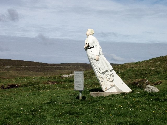
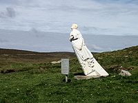
The White Wife of Queyon

Otterswick on the Isle of Yell in the Shetland Islands, on the inlet of Otters Wick. It is on the east side of the island. There is also an "Otterswick" on Sanday in the Orkney Islands.[1]

The surrounding area is a breeding ground of Red-throated Divers,[2] and as the name suggests, there are many otters in the area.

The German ship Bohus was wrecked near here in 1924.[3], and its figurehead, known as the "White Wife of Otterswick"[4] can be seen near the village. The original one, made of wood has rotted away, and it has been replaced by a fibreglass replica.[5] Despite being a German boat, the Bohus was built in Grangemouth on the Firth of Forth, and was originally known as Bertha.[3]

References

  1. ^ Hall, Adrian and Brown, John (September 2005). "Otterswick, Sanday". Edinburgh: Orkney Landscapes: <http://www.fettes.com/orkney/>. http://www.fettes.com/Orkney/otterswick.htm. Retrieved 2009-08-07. [dead link]
  2. ^ "SPA description: Otterswick and Graveland". JNCC. http://www.jncc.gov.uk/default.aspx?page=1934. Retrieved 2009-08-07. 
  3. ^ a b "White Wife of Otterswick". Shetlopedia. http://shetlopedia.com/White_Wife_of_Otterswick. Retrieved 2009-08-07. 
  4. ^ "South East Yell". Sea Kayak Shetrland. http://www.seakayakshetland.co.uk/Yell.htm. Retrieved 2009-08-07. [dead link]
  5. ^ Haswell-Smith, Hamish (2004). The Scottish Islands. Edinburgh: Canongate. ISBN 1841954543. 

Coordinates: 60°33′3″N 1°3′28″W / 60.55083°N 1.05778°W / 60.55083; -1.05778


Wikimedia Foundation. 2010.

Игры ⚽ Нужна курсовая?

Look at other dictionaries:

  • Cross and Burness —    CROSS and BURNESS, a parish, in the island of Sanda, county of Orkney; containing 983 inhabitants, of whom 515 are in Cross, and 468 in Burness. These two ancient parishes, now united, include about onehalf of the island in which they are… …   A Topographical dictionary of Scotland

  • Yell, Shetland — Infobox Scottish island | GridReference=HU492935 celtic name= norse name=Jala meaning of name=Possibly of Pictish origin or from Old Norse for barren area=21,211 ha area rank=11 highest elevation=Hill of Arisdale 210 m Population=957 population… …   Wikipedia

  • List of Special Protection Areas in Scotland — is a list of Special Protection Areas (SPAs) in Scotland.Site nameSite codeCountryArea (ha) Co ordinates StatusAbernethy ForestUK9002561S5793.46coord|57|13|22|N|03|18|10|WClassifiedAchanalt MarshesUK9001701S …   Wikipedia

  • List of Sites of Special Scientific Interest in Shetland — The following is a list of Sites of Special Scientific Interest in the Shetland Area of Search. For other areas, see List of SSSIs by Area of Search.* Aith Meadows * Balta * Breckon * Burn of Aith * Burn of Lunklet * Burn of Valayre * Catfirth *… …   Wikipedia

  • List of places in Shetland — This is a list of towns, villages and smaller settlements on the Shetland Islands, Scotland.Source: [http://www.shetlopedia.com/Shetland Settlements www.shetlopedia.com/Shetland Settlements] compactTOC NOTOC A*Aith, Aithsetter, AywickB*Baliasta,… …   Wikipedia

  • USS Auk (AM-38) — was an Lapwing class minesweeper acquired by the U.S. Navy for the task of removing mines that had been place in the water to prevent ships from passing.The first ship to be named Auk by the Navy, Minesweeper No. 38 was laid down on 20 June 1918… …   Wikipedia

  • Yell (Ecosse) — Yell (Écosse) Pour les articles homonymes, voir Yell. Yell Carte de Yell. Géographie Pays …   Wikipédia en Français

  • Yell (Écosse) — Pour les articles homonymes, voir Yell. Yell Géographie Pays …   Wikipédia en Français

  • Lady —    1) LADY, an isle, in the parish of Dundonald, county of Ayr, 5 miles (S. S. W.) from Irvine, and 5 (N. W. by N.) from Ayr. This island is situated in the Frith of Clyde, about two miles and a half from Troon, the nearest point of the main land …   A Topographical dictionary of Scotland

Share the article and excerpts

Direct link
Do a right-click on the link above
and select “Copy Link”