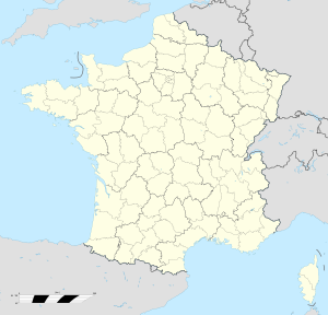
- Ouvrage Champ de Tir
-
Ouvrage Champ de Tir Part of Maginot Line, Alpine Line Southeast France Coordinates 43°53′28″N 7°27′03″E / 43.89123°N 7.45093°ECoordinates: 43°53′28″N 7°27′03″E / 43.89123°N 7.45093°E Built by CORF/MOM Construction
materialsConcrete, steel, rock excavation In use Abandoned Open to
the publicNo Controlled by France Battles/wars Italian invasion of France, Operation Dragoon Ouvrage Champ de Tir Type of work: Small artillery work (Petit ouvrage) sector
└─sub-sectorFortified Sector of the Maritime Alps
└─Sospel, Quartier BrausWork number: EO 4 Regiment: 95th BAF, 158th RAP Number of blocks: 3 Strength: 1 officer, 57 men Ouvrage Champ de Tir, also known as Champ de Tir de l'Agaisen (Agaisen firing range) is a lesser work (petit ouvrage) of the Maginot Line's Alpine extension, the Alpine Line. It is located at an altitude of 672 metres (2,205 ft), less than 1 kilometer to the northwest of Ouvrage l'Agaisen. The ouvrage consists of two entry blocks and one infantry block, sited to control the valley of the Nieya and to observe for l'Agaisen.[1]
Contents
Description
- Block 1 (entry): one machine gun embrasure.[2]
- Block 2 (infantry): one machine gun embrasure.[3]
- Block 3 (infantry): one Machine gun cloche and one twin machine gun embrasure.[4]
The ouvrage is closed to the public.
See also
References
- ^ Mary, Tome 5, p. 59
- ^ Puelinckx, Jean; Aublet, Jean-Louis & Mainguin, Sylvie (2010). "Agaisen (po du champ de tir) Bloc 1" (in French). Index de la Ligne Maginot. fortiff.be. http://www.fortiff.be/maginot/index.php?p=5905. Retrieved 26 January 2010.
- ^ Puelinckx, Jean; et al (2010). "Agaisen (po du champ de tir) Bloc 2" (in French). Index de la Ligne Maginot. fortiff.be. http://www.fortiff.be/maginot/index.php?p=5906. Retrieved 26 January 2010.
- ^ Puelinckx, Jean; et al (2010). "Agaisen (po du champ de tir) Bloc 3" (in French). Index de la Ligne Maginot. fortiff.be. http://www.fortiff.be/maginot/index.php?p=5907. Retrieved 26 January 2010.
Bibliography
- Allcorn, William. The Maginot Line 1928-45. Oxford: Osprey Publishing, 2003. ISBN 1-84176-646-1
- Kaufmann, J.E. and Kaufmann, H.W. Fortress France: The Maginot Line and French Defenses in World War II, Stackpole Books, 2006. ISBN 0-275-98345-5
- Kaufmann, J.E. , Kaufmann, H.W., Jancovič-Potočnik, A. and Lang, P. The Maginot Line: History and Guide, Pen and Sword, 2011. ISBN 978-1-84884-068-3
- Mary, Jean-Yves; Hohnadel, Alain; Sicard, Jacques. Hommes et Ouvrages de la Ligne Maginot, Tome 1. Paris, Histoire & Collections, 2001. ISBN 2-908182-88-2 (French)
- Mary, Jean-Yves; Hohnadel, Alain; Sicard, Jacques. Hommes et Ouvrages de la Ligne Maginot, Tome 4 - La fortification alpine. Paris, Histoire & Collections, 2009. ISBN 978-2-915239-46-1 (French)
- Mary, Jean-Yves; Hohnadel, Alain; Sicard, Jacques. Hommes et Ouvrages de la Ligne Maginot, Tome 5. Paris, Histoire & Collections, 2009. ISBN 978-2-35250-127-5 (French)
External links
- Agaisen (petit ouvrage du champ de tir) at fortiff.be (French)
Fortified Sector of Savoy (La Tarentaise) Fortified Sector of Savoy (La Maurienne) Fortified Sector of the Dauphiné Fortified Sector of the Maritime Alps Col de Crous • Col de la Valette • Rimplas • Fressinéa • Valdeblore • La Séréna • Col du Caire Gros • Col du Fort • Gordolon • Flaut • Baisse de Saint-Véran • Plan Caval • La Béole • Col d'Agnon • La Déa • Col de Brouis • Monte Grosso • Champ de Tir • L'Agaisen • Saint-Roch • Barbonnet • Castillon • Col des Banquettes • Saint-Agnès • Col de Garde • Mont Agel • Roquebrune • Croupe du Réservoir • Cap MartinMaginot Line Corsica 'Categories:- Fortification stubs
- Fortified Sector of the Maritime Alps
- Maginot Line
- Alpine Line
Wikimedia Foundation. 2010.

