- Clinton Group
-
Clinton Group
Stratigraphic range: Late Silurian
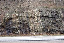
Rocks of the Clinton Group on the east face of Schuylkill GapType sedimentary Sub-units Rochester Shale, Rose Hill Formation, Keefer Formation Underlies Bloomsburg Formation Overlies Tuscarora Formation Thickness 1640 ft Lithology Primary sandstone Other shale Location Region Appalachian Mountains Country United States Extent Pennsylvania, Maryland, New York, West Virginia The Silurian Clinton Group is a mapped bedrock unit in New York, Pennsylvania, Maryland, and West Virginia. It contains the Rochester Shale, Rose Hill Formation[1] and the ridge-forming Keefer Formation.[2] Other names for the members are Reynales Limestone, Williamson Shale, Irondequoit Limestone, and Rochester Shale[2]
Contents
Description
The Clinton Group is defined as a brownish-gray to olive-gray shaly claystone, and a thinly-bedded, fine-grained sandstone, with dark red, fine-grained “iron” sandstone also present. It is approximately 1640 feet thick.[1] The Rochester Shale is a gray, thin-bedded calcareous shale and dark gray, thin- to medium-bedded lenticular limestone. The Keefer Sandstone is a white to yellowish-gray, thick-bedded protoquartzite and orthoquartzite. The Rose Hill Formation is olive-gray to drab, thin-bedded sandstone.[3] The Keefer sandstone has limestone-like properties, because it contains calcite and fossils in addition to quartz.[4]
Economic uses
In Maryland, the Rose Hill Formation contained the Cresaptown Iron Sandstone.[3]
Age
Relative age dating of the Clinton Group places it in the Lower Silurian period. It rests conformably atop the Tuscarora Formation and conformably below the Lower and Upper Silurian Lockport Group[2] and Bloomsburg Formation.[1]
References
- ^ a b c Jackson, Margaret S.; Hanley, Peter M.; and Sak, Peter B. (2007). "Preliminary Bedrock Geologic Map of the Middle Portion of the Susquehanna River Valley, Cumberland, Dauphin, And Perry Counties, Pennsylvania" (pdf). Open File Report OFBM-07-05.0. Pennsylvania Geological Survey. http://www.dcnr.state.pa.us/topogeo/openfile/midsusque.pdf. Retrieved 2008-01-26.
- ^ a b c Ryder, Robert T. et al.. "Possible Continuous-Type (Unconventional) Gas Accumulation in Lower Silurian "Clinton" Sands, Medina Group, and the Tuscarora Sandstone in the Appalachian Basin: A Progress Report of 1995 project activities". USGS. http://pubs.usgs.gov/of/1996/of96-042/sandston.htm. Retrieved 2008-01-26.
- ^ a b "Geologic Maps of Maryland:". http://www.mgs.md.gov/esic/geo/lgdalleg.html. Retrieved 2008-01-26.
- ^ "Field Trip: From tropical shorelines to glacial ice fields, with orogeny mixed in, and all on Tussey Mountain: 400 million years of history". CALL Course on Geology and Environmental Geology of the State College Area. Pennsylvania State University Department of Geosciences,. http://www.geosc.psu.edu/public/CALL/2007trips/Tussey_trip.htm. Retrieved 2008-01-26.
See also
Coordinates: 40°44′05″N 77°46′42″W / 40.73472°N 77.77833°W
Categories:- Geological groups
- Geology of Pennsylvania
- Silurian geologic formations
- Shale
- Sandstone
- Limestone
- Claystone
- Geologic formation stubs
Wikimedia Foundation. 2010.

