- Mangamuka
-
Mangamuka 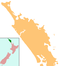
 Mangamuka
Coordinates: 35°14′20″S 173°32′40″E / 35.23889°S 173.54444°E Country New Zealand Region Northland Region District Far North District Mangamuka is a district in Northland, New Zealand, at the junction of the Mangamuka and Opurehu Rivers. State Highway 1 runs through the area, and the settlement of Mangamuka Bridge lies at the point where the highway crosses the Mangamuku River. The river runs into the upper Hokianga Harbour. Just to the north west, the highway runs through Mangamuka Gorge in the Maungataniwha Range.[1] Umawera lies to the south east.
Contents
History
Ngā Puhi chief Hongi Hika was shot in the lungs during a minor engagement on the shores of the Mangamuka River in January 1829. The wound eventually killed him.[2]
The first European surveyor on the Mangamuka River was von Sturmer. The first settlement was at Tutekehua in 1874, downstream from what later became Mangamuka Bridge. The settlers cleared the land, planted orchards, and grew grain. A fruit canning and jam making factory was established, although it no longer exists.[3]
Omahuta Kauri Sanctuary
The Mangamuka Forest survived the logging era with many giant kauri trees intact. In 1952 the Omahuta Kauri Sanctuary was set up to provide public access to the trees, with boardwalks built to both protect the tree roots and keep visitor's feet dry. The walk takes 30-45 minutes.[4][5]
Education
Mangamuka School is a coeducational contributing primary (years 1-6) school with a decile rating of 2 and a roll of 24.[6]
Coordinates: 35°14′20″S 173°32′40″E / 35.23889°S 173.54444°E
Notes
- ^ "Hokianga district". Te Ara Encyclopedia of New Zealand. http://www.teara.govt.nz/Places/Northland/NorthlandPlaces/11/en.
- ^ "HONGI HIKA". Encyclopedia of New Zealand (1966). http://www.teara.govt.nz/1966/H/HongiHika/HongiHika/en.
- ^ Olive Harris and Chris Lancaster, ed (2006). "Early History of Mangamuku River and Tutekehua District, by Jack Julian". Remember the Hokianga. pp. p 283. ISBN 978-0-473-11859-4.
- ^ "Omahuta Kauri Sanctuary, Mangamuka, Hokianga Harbour". http://www.hokianga.net.nz/hokianga/mangamuka/omahuta_kauri_sanctuary.htm.
- ^ "Omahuta Kauri Sanctuary Walk". Department of Conservation (New Zealand). http://www.doc.govt.nz/templates/trackandwalk.aspx?id=36888.
- ^ "Te Kete Ipurangi". Ministry of Education. http://www.tki.org.nz/e/schools/display_school_info.php?school_id=1037.
Categories:- Far North District
- Populated places in New Zealand

Wikimedia Foundation. 2010.