Anseba

Anseba

Infobox Eritrea zoba
Zoba = Anseba Zone (Zoba Anseba)


AdministrationType = Zoba
Capital = Keren
Administrator = Selma Hassan
Population = 457,078
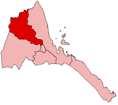
Area = 23,200

Anseba ( _ti. ኣንሰባ) is an inland region of Eritrea, in the west of the country. Its capital is Keren and it has an area of about 23,000 km². It is named after the river around which the region is situated. The river begins in the central Eritrean highland plateau, in the suburbs northwest of the capital Asmara and descends northwards into the northwestern lowlands traversing the mountains of Rora Habab and Sahel before flowing out into the Red Sea in the neighbouring country of Sudan in the vicinity of the port of Suakin. Other towns in this region include Halhal. The region borders Gash-Barka to the south, the Central region to the south-east and the Northern Red Sea region to the east and north, and the nation of Sudan to the west.

The region also includes the following districts:
* Adi Tekelezan
* Asmat
* Elabored
* Geleb
* Hagaz
* Halhal
* Habero
* Keren City
* Kerkebet
* Sela

Sources

* [http://www.geohive.com/cd/link.php?xml=er&xsl=neo1 GeoHive]


Wikimedia Foundation. 2010.

Игры ⚽ Поможем сделать НИР

Look at other dictionaries:

  • Anseba — Basisdaten Land: Eritrea Hauptort: Keren Fläche …   Deutsch Wikipedia

  • Anseba — Saltar a navegación, búsqueda Zoba Anseba Tipo de administración Zoba Administrador Mohammed Saeed …   Wikipedia Español

  • Anseba S.C. — Football club infobox clubname = Anseba S.C. fullname = Anseba Sport Club nickname = founded = ground = Olympic Stadium Asmara, Eritrea capacity = 10,000 chairman = manager = league = Eritrean Second League season = 2006/07 position = Anseba S.C …   Wikipedia

  • Anseba — Admin ASC 1 Code Orig. name Ānseba Country and Admin Code ER.01 ER …   World countries Adminstrative division ASC I-II

  • Anseba River — The Anseba River flows from the Eritrean Highlands to the plains of Sudan. With a length of 346 kilometers, the Anseba rises outside of Asmara and flows in a northwestern direction through Keren. It merges with the Barka River near the border… …   Wikipedia

  • Logo Anseba — is one of the sub regions of Gash Barka. It is located in the highlands of Eritrea where it borders with the Anseba, Maekel and Debub regions. It is at an altitude between 1600 2400 meters above sea level, with a semi arid climate. The total… …   Wikipedia

  • Logo Anseba District — Infobox Settlement name = Logo Anseba settlement type =District official name = other name = native name = nickname = motto = imagesize = image caption = flag size = image seal size = image shield = shield size = image blank emblem = blank emblem …   Wikipedia

  • Adi Ali Bakit, Anseba — Infobox Settlement official name = Adi Ali Bakit native name = imagesize = image caption = image map caption = pushpin pushpin label position =bottom pushpin mapsize = 300 pushpin map caption =Location in Eritrea subdivision type = Country… …   Wikipedia

  • ER-AN — Anseba Basisdaten Land: Eritrea Hauptort: Keren Fläche …   Deutsch Wikipedia

  • Keren District — Keren   District   Country  Eritrea Region Anseba …   Wikipedia

Share the article and excerpts

Direct link
Do a right-click on the link above
and select “Copy Link”