Dunton Bassett

Dunton Bassett
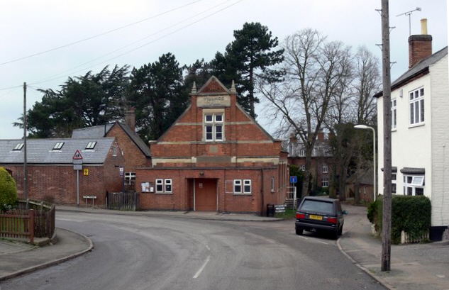
Dunton Bassett village hall

Dunton Bassett is a small village in the Harborough District of Leicestershire. It lies between Leicester and Lutterworth, and close to Broughton Astley, Ashby Magna & Leire. It had a population of 795 at the 2001 UK census.

The village has two pubs (the Dunton Bassett Arms and the Merri Monk), one village shop / post office and one used car lots.

The village hall was donated to the village by Orson Wright, a successful builder who had been born in the village.

The Great Central main railway line, the last main line to be built from the north of England to London, was opened on 15 March 1899 and ran just to the east of Dunton Bassett, separating it from the village of Ashby Magna, and a station was provided bearing that settlement's name although it was much the smaller village of the two. Dunton Bassett gave its name to a short (92 yard) tunnel just south of the station. The line closed on 5 May 1969. In its latter years it had been joined by the M1 motorway which parallelled it on the east side.

External links

Media related to Dunton Bassett at Wikimedia Commons

Coordinates: 52°30′37″N 1°11′45″W / 52.51028°N 1.19583°W / 52.51028; -1.19583


Wikimedia Foundation. 2010.

Игры ⚽ Поможем написать реферат

Look at other dictionaries:

  • Dunton — is the name of more than one place. In the United Kingdom: Dunton, Bedfordshire Dunton, Buckinghamshire Dunton, Norfolk Dunton Bassett, Leicestershire Dunton Green, Kent Dunton Wayletts, Essex This disambiguation page lists article …   Wikipedia

  • Earl Shilton — Infobox UK place official name= Earl Shilton country = England os grid reference= SP472980 latitude= 52.57777 longitude= 1.30491 map type= Leicestershire civil parish= population = shire district= Hinckley and Bosworth shire county=… …   Wikipedia

  • Harborough — This is about the district of Harborough; there is also the Harborough constituency. Infobox UK district name = Harborough District status = District region = East Midlands admincounty = Leicestershire area = Ranked 79th 592.70 km² adminhq =… …   Wikipedia

  • List of places in Leicestershire — Location map+|Leicestershire caption = Some of the larger settlements of Leicestershire. float = right width = 350 places = Location map |Leicestershire label = Melton Mowbray long = 0.886 lat = 52.7661 background = white Location map… …   Wikipedia

  • List of civil parishes in Leicestershire — Blaby= *Aston Flamville 1 *Blaby 1 *Town of Braunstone 1 *Cosby 1 *Countesthorpe 1 *Croft 1 *Elmesthorpe 1 *Enderby 1 *Glenfield (Glenfields) 1 *Glen Parva 1 *Huncote 1 *Kilby 1 *Kirby Muxloe 1 *Leicester Forest East 1 *Leicester Forest West 1… …   Wikipedia

  • Ashby Magna — infobox UK place country = England static static image caption= latitude= 52.50 longitude= 01.17 official name =Ashby Magna population = shire district= shire county= Leicestershire metropolitan borough= metropolitan county = region=East Midlands …   Wikipedia

  • Lutterworth Rural District — The rural district of Lutterworth in Leicestershire, England existed from 1894 to 1974. It contained the following civil parishes :*Arnesby *Ashby Magna *Ashby Parva *Bittesby *Bitteswell *Broughton Astley *Bruntingthorpe *Catthorpe *Claybrooke… …   Wikipedia

  • Almey — This interesting and unusual surname is of Anglo Saxon origin, and is either a topographical name from residence by a stretch of wet land where elms grew, deriving from the Olde English pre 7th Century elm , elm, with the Old Scandinavian ey… …   Surnames reference

  • Marsworth — Coordinates: 51°49′21″N 0°39′58″W / 51.8225°N 0.6661°W / 51.8225; 0.6661 …   Wikipedia

  • South Wigston — infobox UK place country= England latitude= 52.5802 longitude= 1.13288 official name= South Wigston population= shire district= Oadby and Wigston shire county= Leicestershire region= East Midlands constituency westminster= Harborough post town=… …   Wikipedia

Share the article and excerpts

Direct link
Do a right-click on the link above
and select “Copy Link”