- Dukla
-
This article is about a town in Poland. For other uses, see Dukla (disambiguation).
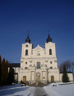
Dukla Church of the Bernardyni Fathers in Dukla 
Coat of armsCoordinates: 49°34′N 21°41′E / 49.567°N 21.683°E Country  Poland
Voivodeship  Subcarpathian
County Krosno Gmina Dukla Area - Total 5.48 km2 (2.1 sq mi) Population (2006) - Total 2,136 - Density 389.8/km2 (1,009.5/sq mi) Postal code 38-450 Website http://www.dukla.pl Dukla [ˈdukla]; Ukrainian and Russian: Дукля, Duklya] is a town and an eponymous municipality in southeastern Poland, in the Subcarpathian Voivodship. The town is populated by 2,127 people (02.06.2009).[1] while the total population of the commune (gmina) containing the town and the villages surrounding it is 16,640.[1] The total area of the commune is 333,04 km².
The Dukla mountain pass is located in the Carpathians, a few kilometers south of Dukla, on the border with Slovakia and was a scene of a major battle in 1944.
The city of Krosno is located to the north of Dukla.
Hiking trails
- European walking route E8
- Prešov - Miháľov - Kurimka - Dukla - Iwonicz-Zdrój – Rymanów-Zdrój - Puławy – Tokarnia (778 m) – Kamień (717 m) – Komańcza - Cisna - Ustrzyki Górne - Tarnica - Wołosate.
References
- Notes
- ^ a b "Population. Size and structure by territorial division". © 1995-2009 Central Statistical Office 00-925 Warsaw, Al. Niepodległości 208. 2009-06-02. http://www.stat.gov.pl/cps/rde/xbcr/gus/PUBL_P_population_size_structure_31_12_2008.pdf. Retrieved 2009-06-22.
External links
Coordinates: 49°34′N 21°41′E / 49.567°N 21.683°E
Town and seat Dukla
Villages Barwinek • Cergowa • Chyrowa • Głojsce • Iwla • Jasionka • Łęki Dukielskie • Lipowica • Mszana • Myszkowskie • Nadole • Nowa Wieś • Olchowiec • Ropianka • Równe • Smereczne • Teodorówka • Trzciana • Tylawa • Wietrzno • Wilsznia • Zawadka Rymanowska • Zboiska • ZyndranowaCategories:- Cities and towns in Podkarpackie Voivodeship
- Krosno County
- Shtetls
- Krosno County geography stubs
- European walking route E8
Wikimedia Foundation. 2010.


